
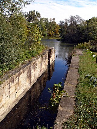
The Erie Canal is a historic canal in upstate New York that runs east–west between the Hudson River and Lake Erie. Completed in 1825, the canal was the first navigable waterway connecting the Atlantic Ocean to the Great Lakes, vastly reducing the costs of transporting people and goods across the Appalachians. The Erie Canal accelerated the settlement of the Great Lakes region, the westward expansion of the United States, and the economic ascendancy of New York state. It has been called "The Nation's First Superhighway".
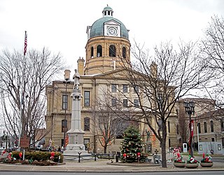
Tuscarawas County is a county located in the northeastern part of the U.S. state of Ohio. As of the 2020 census, the population was 93,263. Its county seat is New Philadelphia. Its name is a Delaware Indian word variously translated as "old town" or "open mouth". Tuscarawas County comprises the New Philadelphia–Dover, OH Micropolitan Statistical Area, which is also included in the Cleveland–Akron–Canton, OH Combined Statistical Area.

Put-in-Bay is a resort village located on South Bass Island in Put-in-Bay Township, Ottawa County, Ohio, United States, 85 miles (137 km) west of Cleveland and 35 miles (56 km) east of Toledo. The population was 154 at the 2020 census.
Milan is a village in Erie and Huron counties in the U.S. state of Ohio. The population was 1,371 at the 2020 census. It is best known as the birthplace and childhood home of Thomas Edison.

Tonawanda is a city in Erie County, New York, United States. The population was 15,129 at the 2020 census. It is at the northern edge of Erie County, south across the Erie Canal from North Tonawanda, east of Grand Island, and north of Buffalo. It is part of the Buffalo-Niagara Falls metropolitan area.

The Schuylkill River is a river in eastern Pennsylvania. It flows for 135 miles (217 km) from Pottsville southeast to Philadelphia, the nation's sixth-largest city, where it joins the Delaware River as one of its largest tributaries.

The Ohio Rhineland is a German cultural region of Ohio. It was named by Rhinelanders and other Germans who settled the area in the mid-19th century. They named the canal "the Rhine" in reference to the river Rhine in Germany, and the newly settled area north of the canal as "Over the Rhine".
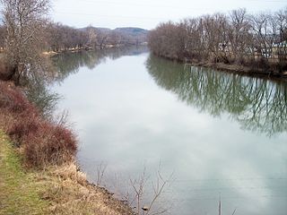
The Tuscarawas River is a principal tributary of the Muskingum River, 129.9 miles (209 km) long, in northeastern Ohio in the United States. Via the Muskingum and Ohio rivers, it is part of the watershed of the Mississippi River, draining an area of 2,590 square miles (6,700 km2) on glaciated and unglaciated portions of the Allegheny Plateau.
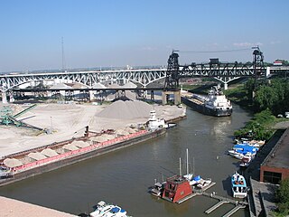
The Flats is a mixed-use industrial, recreational, entertainment, and residential area of the Cuyahoga Valley neighborhood of Cleveland, Ohio, U.S. The name reflects its low-lying topography on the banks of the Cuyahoga River.

The Ohio and Erie Canal was a canal constructed during the 1820s and early 1830s in Ohio. It connected Akron with the Cuyahoga River near its outlet on Lake Erie in Cleveland, and a few years later, with the Ohio River near Portsmouth. It also had connections to other canal systems in Pennsylvania.

The Warren County Canal was a branch of the Miami and Erie Canal in southwestern Ohio about 20 miles (32 km) in length that connected the Warren County seat of Lebanon to the main canal at Middletown in the mid-19th century. Lebanon was at the crossroads of two major roads, the highway from Cincinnati to Columbus and the road from Chillicothe to the College Township (Oxford), but Lebanon businessmen and civic leaders wanted better transportation facilities and successfully lobbied for their own canal, part of the canal fever of the first third of the 19th century. The Warren County Canal was never successful, operating less than a decade before the state abandoned it.

Buffalo is the county seat of Erie County, and the second most populous city in the U.S. state of New York, after New York City. Originating around 1789 as a small trading community inhabited by the Neutral Nation near the mouth of Buffalo Creek, the city, then a town, grew quickly after the opening of the Erie Canal in 1825, with the city at its western terminus. Its position at the eastern end of Lake Erie strengthened the economy, based on grain milling and steel production along the southern shores and in nearby Lackawanna.
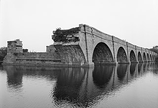
Schoharie Crossing State Historic Site, also known as Erie Canal National Historic Landmark, is a historic district that includes the ruins of the Erie Canal aqueduct over Schoharie Creek, and a 3.5-mile (5.6 km) long part of the Erie Canal, in the towns of Glen and Florida within Montgomery County, New York. It was the first part of the old canal to be designated a National Historic Landmark, prior to the designation of the entire New York State Barge Canal as an NHL in 2017.

Buckeye Lake is a reservoir in Fairfield, Licking, and Perry counties in the U.S. state of Ohio. The lake was created in the 19th century as the "Licking Summit Reservoir", an important part of the Ohio and Erie Canal project. With the demise of the canal system in the early 20th century, usage of the lake shifted to recreation.
The Walhonding Canal was a canal in Coshocton County, Ohio that was used as a feeder canal for the Ohio and Erie Canal. A small canal, at only 25 miles (40.2 km) long, it was wholly contained within Coshocton County, following the Mohican River from Cavallo south to the confluence with the Kokosing River, which together with the Mohican forms the Walhonding River. The canal followed the Walhonding River southeast toward Coshocton where it met the Ohio and Erie Canal in Roscoe Village.

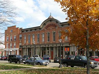
The Johnson-Humrickhouse Museum is a general interest museum within historic Roscoe Village, a restored Ohio & Erie Canal town in Coshocton, OH. It has four permanent themed exhibits within five galleries, including a Native American Gallery, Historic Ohio, Asian, and 19th and 20th Century Decorative Arts. There are more than 17,000 items in its collections.

Canalside, formerly known as Canal Side and also referred to as Erie Canal Harbor, is a mixed-use recreational and entertainment district in downtown Buffalo, New York. It is the recreation of the western terminus of the Erie Canal, which was destroyed in the early 20th century. Canalside is situated on the Buffalo River, in an area that was historically home to the Seneca people.
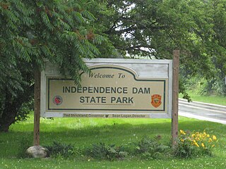
Independence Dam State Park is a 591-acre (239 ha) public recreation area located on the banks of the Maumee River three miles east of Defiance in Defiance County, Ohio, United States. The state park features ruins of the Miami and Erie Canal. Recreational features include boating, fishing, hiking, picnicking, and primitive camping.
The Wheeling and Lake Erie Railway was a Class I railroad mostly within the U.S. state of Ohio. It was leased to the New York, Chicago and St. Louis Railroad in 1949, and merged into the Norfolk and Western Railway in 1988. A new regional railroad reused the Wheeling and Lake Erie Railway name in 1990 when it acquired most of the former W&LE from the N&W.

The Boston Mills Historic District is a historic district in the Cuyahoga Valley National Park in Northeast Ohio in the United States. With the opening of the Ohio and Erie Canal in 1827, people began to settle in this vicinity. By 1842, there was a water-powered mill, a large warehouse, a boat-yard, two stores and a hotel, and the population was around 300. A number of houses and other buildings dating back to that period remain.


