Related Research Articles

The Loop is Chicago's central business district and one of the city's 77 municipally recognized community areas. Located at the center of downtown Chicago on the shores of Lake Michigan, it is the second-largest business district in North America after Midtown Manhattan. The headquarters and regional offices of several global and national businesses, retail establishments, restaurants, hotels, and theaters–as well as many of Chicago's most famous attractions–are located in the Loop. The neighborhood also hosts Chicago's City Hall, the seat of Cook County, offices of other levels of government, and several foreign consulates. The intersection of State Street and Madison Street in the Loop is the origin point for the address system on Chicago's street grid.

Michigan Avenue is a north-south street in Chicago that runs at 100 east on the Chicago grid. The northern end of the street is at DuSable Lake Shore Drive on the shore of Lake Michigan in the Gold Coast Historic District. The street's southern terminus is at Sibley Boulevard in the southern suburb of Dolton, but like many other Chicago streets, it exists in several disjointed segments.

Streeterville is a neighborhood in the Near North Side community area of Chicago, Illinois, United States, north of the Chicago River. It is bounded by the river on the south, the Magnificent Mile portion of Michigan Avenue on the west, and Lake Michigan on the north and east, according to most sources, although the city of Chicago recognizes only a small portion of this region as Streeterville. Thus, it can be described as the Magnificent Mile plus all land east of it. The tourist attraction of Navy Pier and Ohio Street Beach extend out into the lake from southern Streeterville. To the north, the East Lake Shore Drive District, where the Drive curves around the shoreline, may be considered an extension of the Gold Coast. The majority of the land in this neighborhood is reclaimed sandbar.

Jackson Park is a 551.5-acre (223.2 ha) urban park on the shore of Lake Michigan on the South Side of Chicago. Straddling the Hyde Park, Woodlawn, and South Shore neighborhoods, the park was designed in 1871 by Frederick Law Olmsted and Calvert Vaux and remodeled in 1893 to serve as the site of the World's Columbian Exposition. It is one of the largest and most historically significant parks in the city, and many of the park's features are mementos of the fair—including the Garden of the Phoenix, the Statue of TheRepublic, and the Museum of Science and Industry.
South Shore is one of 77 defined community areas of Chicago, Illinois, United States. Located on the city's South Side, the area is named for its location along the city's southern lakefront. Although South Shore has seen a greater than 40% decrease in residents since Chicago's population peaked in the 1950s, the area remains one of the most densely populated neighborhoods on the South Side. The community benefits from its location along the waterfront, its accessibility to Lake Shore Drive, and its proximity to major institutions and attractions such as the University of Chicago, the Museum of Science and Industry, and Jackson Park.

Parks in Chicago include open spaces and facilities, developed and managed by the Chicago Park District. The City of Chicago devotes 8.5% of its total land acreage to parkland, which ranked it 13th among high-density population cities in the United States in 2012. Since the 1830s, the official motto of Chicago has been Urbs in horto, Latin for "City in a garden" for its commitment to parkland. In addition to serving residents, a number of these parks also double as tourist destinations, most notably Lincoln Park, Chicago's largest park, visited by over 20 million people each year, is one of the most visited parks in the United States. Notable architects, artists and landscape architects have contributed to the 570 parks, including Daniel Burnham, Frederick Law Olmsted, Jens Jensen, Dwight Perkins, Frank Gehry, and Lorado Taft.

Kenwood, one of Chicago's 77 community areas, is on the shore of Lake Michigan on the South Side of the city. Its boundaries are 43rd Street, 51st Street, Cottage Grove Avenue, and the lake. Kenwood was originally part of Hyde Park Township, which was annexed to the city of Chicago in 1889. Kenwood was once one of Chicago's most affluent neighborhoods, and it still has some of the largest single-family homes in the city. It contains two Chicago Landmark districts, Kenwood and North Kenwood. A large part of the southern half of the community area is in the Hyde Park-Kenwood Historic District. In recent years, Kenwood has received national attention as the home of former U.S. President Barack Obama.

Chatham is one of the 77 community areas of Chicago, Illinois, on the city's South Side. It includes the neighborhoods of Chatham-Avalon, Chatham Club, Chesterfield, East Chatham, West Chatham and the northern portion of West Chesterfield. Its residents are predominantly African American, and it is home to former Senator Roland Burris. Housing many city employees and other officials, Chatham has been a central area for Chicago's middle-class African Americans since the late 1950s.

South Chicago, formerly known as Ainsworth, is one of the 77 community areas of Chicago, Illinois.

Promontory Point is a man-made peninsula jutting into Lake Michigan. It is located in Chicago's Burnham Park. The Point was constructed from landfill and by the late 1930s was protected by a seawall or revetment. The revetment was designed and constructed by Chicago Park District engineers and consists of limestone blocks arranged in a series of four steps leading to a promenade.

Stony Island Avenue is a major street on South Side of the city of Chicago, designated 1600 East in Chicago's street numbering system. It runs from 56th Street south to the Calumet River. Stony Island Avenue continues sporadically south of the Calumet in the southern suburbs, running alongside the Bishop Ford Freeway, sometimes as a frontage road. It terminates at County Line Road on the border of Will and Kankakee Counties.
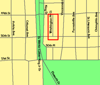
The Washington Park Court District is a Grand Boulevard community area neighborhood on the South Side of Chicago, Illinois. It was designated a Chicago Landmark on October 2, 1991. Despite its name, it is not located within either the Washington Park community area or the Washington Park park, but is one block north of both. The district was named for the Park.

The Printing House Row District is a National Historic Landmark District encompassing four architecturally important buildings on South Dearborn Street, between Jackson Boulevard and Ida B. Wells Drive, in the Loop community area of Chicago, Illinois. It was listed on the National Register of Historic Places as South Dearborn Street – Printing House Row Historic District and listed as a National Historic Landmark as South Dearborn Street – Printing House Row North Historic District on January 7, 1976. The district includes the Monadnock Building, the Manhattan Building, the Fisher Building, and the Old Colony Building.

The East Lake Shore Drive District is a historic district in the Near North Side community area of Chicago, Illinois. It includes eight buildings at 140 E. Walton, 179-229 E. Lake Shore Drive, and 999 N. Lake Shore Drive designed by Marshall and Fox and Fugard & Knapp and the opposing park. It was designated a Chicago Landmark district on April 18, 1985. These buildings include seven luxury high rise apartment buildings and the Drake Hotel. Note that neither of the buildings on either end of the district actually has an East Lake Shore Drive address. This district is located within the Streeterville neighborhood and overlaps with the Gold Coast.

The Kenwood District is a historic district in the officially designated Kenwood community area of Chicago, Illinois bounded by E. 47th and E. 51st Streets, S. Blackstone and S. Drexel Avenues. It was designated a Chicago Landmark on June 29, 1979. The official community areas were defined in the early 20th century and the current meaning of the Hyde Park neighborhood includes the area between 47th Street and 51st Street as a part of Hyde Park, although this area is officially the south half of the official Kenwood neighborhood. The region is part of the Hyde Park-Kenwood Historic District.

The Historic Michigan Boulevard District is a historic district in the Loop community area of Chicago in Cook County, Illinois, United States encompassing Michigan Avenue between 11th or Roosevelt Road, depending on the source, and Randolph Streets and named after the nearby Lake Michigan. It was designated a Chicago Landmark on February 27, 2002. The district includes numerous significant buildings on Michigan Avenue facing Grant Park. This section of Michigan Avenue includes the eastern terminus of U.S. Route 66. The district is one of the world's best known one-sided streets rivalling Fifth Avenue in New York City and Edinburgh's Princes Street. It lies immediately south of the Michigan–Wacker Historic District and east of the Loop Retail Historic District.

The Wicker Park District is a historic district in the West Town community area of Chicago, Illinois. It is the neighborhood bounded by Bell Avenue, Caton Street, Leavitt Street, Potomac Avenue and Chicago 'L' tracks. It was designated a Chicago Landmark on April 12, 1991.
The South Side is one of the three major sections of the city of Chicago, Illinois, United States. Geographically, it is the largest of the three sections of the city, with the other two being the North and West Sides. It radiates and lies south of the city's downtown area, the Chicago Loop.

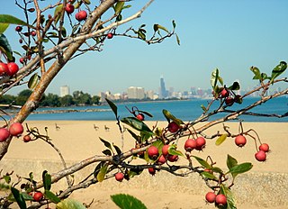
Indian Village is the small southeast corner of Kenwood, a community area on the South Side of Chicago, Illinois, United States. It is bounded by Lake Shore Drive to the east, Burnham Park to the north, 51st Street to the south, Harold Washington Park to the southeast, and the Illinois Central Railroad tracks used by the South Shore and Metra Electric Lines to the west. Many of the buildings in the neighborhood are named after American Indian tribes including the National Register of Historic Places (NRHP)-designated Narragansett; the Powhatan Apartments, a Chicago Landmark; the Chippewa; and the Algonquin Apartment buildings.
References
- ↑ "Jackson Park Highlands District". City of Chicago Department of Planning and Development, Landmarks Division. 2003. Archived from the original on 2007-06-07. Retrieved 2007-06-26.
- ↑ McLenahan, William (October 25, 1989). "Designation of Jackson Park Highlands District as Chicago Landmark" (PDF). Chicago City Council Journal of Proceedings. pp. 5929–5934. Retrieved November 29, 2019.
41°46′12″N87°34′44″W / 41.770°N 87.579°W
| Authority control databases: Geographic |
|---|