Related Research Articles
Burnham is a village in Cook County, Illinois, United States. The population was 4,046 at the 2020 census. The ZIP code is 60633.

Markham is a city and a south suburb of Chicago in Cook County, Illinois, United States. The population was 11,661 at the 2020 census.

South Holland is a village and south suburb of Chicago in Cook County, Illinois, United States, within Thornton Township. The population was 21,465 at the 2020 census.
The Calumet Region is the geographic area drained by the Grand Calumet River and the Little Calumet River of northeastern Illinois and northwestern Indiana in the United States. It is part of the Great Lakes Basin, which eventually reaches the Atlantic Ocean. It is a sub-region of the greater Northwest Indiana region and the even larger Great Lakes region.

Illinois's 2nd congressional district is a congressional district in the U.S. state of Illinois. Based in the south suburbs of Chicago, the district includes southern Cook county, eastern Will county, and Kankakee county, as well as the city of Chicago's far southeast side.
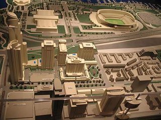
Central Station is a residential development project in the South Loop section of Chicago, Illinois. Originally planned as a 69 acres (28 ha) development, it was later expanded to 72 acres (29 ha), and is now 80 acres (32 ha). Being planned by the city government, it encompasses the former rail yards and air space rights east of Michigan Avenue between Roosevelt Road and 18th Street.

Stony Island Avenue is a major street on South Side of the city of Chicago, designated 1600 East in Chicago's street numbering system. It runs from 56th Street south to the Calumet River. Stony Island Avenue continues sporadically south of the Calumet in the southern suburbs, running alongside the Bishop Ford Freeway, sometimes as a frontage road. It terminates at County Line Road on the border of Will and Kankakee Counties.

The Black Metropolis–Bronzeville District is a historic African American district in the Bronzeville neighborhood of the Douglas community area on the South Side of Chicago, Illinois.

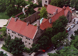
The Prairie Avenue District is a historic district in the Near South Side community area of Chicago, Illinois. It includes the 1800 and 1900 blocks of South Prairie Avenue and the 1800 block of South Indiana, and 211-217 East Cullerton. It was the site of the Battle of Fort Dearborn and became the city's most fashionable residential district after the Great Chicago Fire. It was designated a Chicago Landmark on December 27, 1979. The district was added to the National Register of Historic Places on November 15, 1972. The John J. Glessner House, designed and built by Henry Hobson Richardson in 1885–1886 at 1800 S. Prairie Avenue, has been restored as a historic house museum, and is open for public tours. In 2006, the Prairie District Neighborhood Alliance, a non-profit organization was formed to provide representation for thousands of South Loop residents, including the Prairie Avenue District, Central Station, Museum Park, Motor Row, and the South Michigan Avenue Corridor, as well as other areas of the Near South Side.

The East Lake Shore Drive District is a historic district in the Near North Side community area of Chicago, Illinois. It includes eight buildings at 140 E. Walton, 179-229 E. Lake Shore Drive, and 999 N. Lake Shore Drive designed by Marshall and Fox and Fugard & Knapp and the opposing park. It was designated a Chicago Landmark district on April 18, 1985. These buildings include seven luxury high rise apartment buildings and the Drake Hotel. Note that neither of the buildings on either end of the district actually has an East Lake Shore Drive address. This district is located within the Streeterville neighborhood and overlaps with the Gold Coast.

The Kenwood District is a historic district in the officially designated Kenwood community area of Chicago, Illinois bounded by E. 47th and E. 51st Streets, S. Blackstone and S. Drexel Avenues. It was designated a Chicago Landmark on June 29, 1979. The official community areas were defined in the early 20th century and the current meaning of the Hyde Park neighborhood includes the area between 47th Street and 51st Street as a part of Hyde Park, although this area is officially the south half of the official Kenwood neighborhood. The region is part of the Hyde Park-Kenwood Historic District.
The Jackson Park Highlands District is a historic district in the South Shore community area of Chicago, Illinois, United States. The district was built in 1905 by various architects. It was designated a Chicago Landmark on October 25, 1989.
The Longwood Drive District is a historic district in Chicago, Illinois. The houses along Longwood Drive in the Beverly neighborhood were built beginning in 1873 by various architects. Longwood was named for a long copse of trees that ran along the lee side of the hill where the rest of Beverly is located. The area was designated a Chicago Landmark on November 13, 1981. The Longwood Drive has a mixture of different styles of architecture, such as Italianate, Carpenter Gothic, Queen Anne, Shingle, Prairie School, and Renaissance Revival.
Old Edgebrook is a historic district and neighborhood in the Forest Glen community area of Chicago, Illinois, United States.
95th Street is a major east–west highway on Chicago's South Side, and in the southwest suburbs, is designated as 9500 South in Chicago's address system. 95th Street is 11 miles (18 km) south of Madison Street.
Prairie Avenue is a north–south street on the South Side of Chicago, which historically extended from 16th Street in the Near South Side to the city's southern limits and beyond. The street has a rich history from its origins as a major trail for horseback riders and carriages. During the last three decades of the 19th century, a six-block section of the street served as the residence of many of Chicago's elite families and an additional four-block section was also known for grand homes. The upper six-block section includes part of the historic Prairie Avenue District, which was declared a Chicago Landmark and added to the National Register of Historic Places.

Pill Hill is a neighborhood in the Calumet Heights community area on the South Side of Chicago, Illinois, United States.

Generally, the Chicago Harbor comprises the public rivers, canals, and lakes within the territorial limits of the City of Chicago and all connecting slips, basins, piers, breakwaters, and permanent structures therein for a distance of three miles from the shore between the extended north and south lines of the city. The greater Chicago Harbor includes portions of the Chicago River, the Calumet River, the Ogden Canal, the Chicago Sanitary and Ship Canal, Lake Calumet, and Lake Michigan.
Kensington is a neighborhood in the Far South Side of Chicago. Founded as the town of Calumet Junction in 1852, it began as a small community of rail-workers servicing the junction of the Illinois Central and Michigan Central railroads. It was nicknamed "Bumtown" by neighbors, though the origin is unclear. When the Pullman Sleeping Car Company established itself nearby, Kensington swelled with workers that could not or would not live in the Pullman company town. The commercial district around Kensington station boomed as Pullman residents escaped the company run stores: the saloons along Front Avenue found particular success in serving the dry town's denizens. The 1894 Pullman strike was headquartered in a Kensington clubhouse. As the Far South Side developed and immigrants came seeking work, Italians moved into Kensington. They were soon the majority, and the neighborhood remained a vibrant Italian enclave until the 1970s. Today, Kensington is a Hispanic enclave centered around a smaller commercial district, and the Front Avenue saloons are gone.
References
- ↑ "Calumet/Giles Prairie District". City of Chicago Department of Planning and Development, Landmarks Division. 2003. Archived from the original on June 7, 2007. Retrieved June 26, 2007.