Related Research Articles

Walter Burley Griffin was an American architect and landscape architect. He designed Canberra, Australia's capital city, the New South Wales towns of Griffith and Leeton, and the Sydney suburb of Castlecrag.

Marion Mahony Griffin was an American architect and artist. She was one of the first licensed female architects in the world, and is considered an original member of the Prairie School. Her work in the United States developed and expanded the American Prairie School, and her work in India and Australia reflected Prairie School ideals of indigenous landscape and materials in newly formed democracies. The scholar Debora Wood stated that Griffin "did the drawings people think of when they think of Frank Lloyd Wright ." According to architecture critic, Reyner Banham, Griffin was "America’s first woman architect who needed no apology in a world of men."

Prairie School is a late 19th and early 20th-century architectural style, most common in the Midwestern United States. The style is usually marked by horizontal lines, flat or hipped roofs with broad overhanging eaves, windows grouped in horizontal bands, integration with the landscape, solid construction, craftsmanship, and discipline in the use of ornament. Horizontal lines were thought to evoke and relate to the wide, flat, treeless expanses of America's native prairie landscape.
The McCormick Row House District is a group of houses located in the Lincoln Park community area in Chicago, Illinois, United States. It sits between the east and west parts of DePaul University's Lincoln Park Campus and is independent from the establishment. The houses were built between 1884 and 1889 and used by the McCormick Theological Seminary to gain rental income. They were designed in the Queen Anne style by A. M. F. Colton and Son architects and joined the list of Chicago Landmarks on May 4, 1971. The McCormick Row House District also lies within the boundaries of the Sheffield Historic District.

The Chicago Avenue Pumping Station is a historic district contributing property in the Old Chicago Water Tower District landmark district. It is located on Michigan Avenue along the Magnificent Mile shopping district in the Near North Side community area of Chicago, Illinois. It is on the east side of Michigan Avenue opposite the Chicago Water Tower.

The Arlington and Roslyn Place District is a historic district in Chicago, Illinois, United States. The district was built between 1894 and 1910 by various architects. It was designated a Chicago Landmark on November 15, 1989.

The Armitage-Halsted District is a historic district in the Lincoln Park community area of Chicago, Illinois, United States. The district was built between 1870 and 1930 by various architects. It was designated a Chicago Landmark on February 5, 2003.
The Burling Row House District is a historic district in Chicago, Illinois, United States. The district was built in the post-Chicago Fire year of 1875 by Edward J. Burling. It was designated a Chicago Landmark on November 15, 2000.
The Calumet/Giles Prairie District is a historic district in the South Side, Chicago community area of Chicago, Illinois, United States. The district was built between 1870 and 1910 by various architects. It was designated a Chicago Landmark on July 13, 1988.
The Five Houses on Avers District is a historic district in Chicago, Illinois, United States. The district was built between 1892 and 1894 by Frederick B. Townsend. It was designated a Chicago Landmark on March 2, 1994.

The Hawthorne Place District is a historic district in Chicago, Illinois, United States. The district was built in the 1890s by various architects including the McConnell brothers, Burnham & Root, and Pond & Pond. It was designated a Chicago Landmark on March 26, 1996.

The Jewelers Row District is a historic district in the Loop community area of Chicago, Illinois in the United States. Running along Wabash Avenue, primarily between East Washington Street and East Monroe Street, the buildings in the district were built between 1872 and 1941 and were designed by many architects, including Graham, Anderson, Probst & White, John Mills Van Osdel, Adler & Sullivan, Alfred Alschuler, D. H. Burnham & Co., and Holabird & Roche in a variety of styles, including Italianate, Chicago School, and Art Deco. The buildings are variously loft buildings used for small manufacturers, mercantile buildings, office buildings and early skyscrapers.

The Mid-North District or Midtown-North is a historic district in the Lincoln Park community area of Chicago, Illinois. The district was built from 1865 to 1900 by various architects. It is bounded by Fullerton Avenue to the north, Armitage Avenue to the south, Lincoln Avenue to the west and Clark Street to the east. It was designated a Chicago Landmark on August 31, 1977.
The Oakland District is a historic district in the Oakland community area of Chicago, Illinois, United States. The district was built between 1872 and 1905 by Cicero Hine and other various architects. It was designated a Chicago Landmark on March 25, 1992.
Old Edgebrook is a historic district and neighborhood in the Forest Glen community area of Chicago, Illinois, United States.

The Seven Houses on Lake Shore Drive District is a historic district in Chicago, Illinois, United States. The district was built between 1889 and 1917 by various architects including Benjamin Marshall, Holabird & Roche, Howard Van Doren Shaw, and McKim, Mead & White. It was designated a Chicago Landmark on June 28, 1989.

The Gauler Twin Houses are two specular Prairie style houses located at 5917 and 5921 North Magnolia Avenue in Chicago, Illinois, United States. The houses were built in 1908 by Walter Burley Griffin for John Gauler, a land speculator. They were added to the National Register of Historic Places on June 17, 1977 and designated a Chicago Landmark on June 28, 2000.

The Ryerson & Burnham Libraries are the art and architecture research collection of the Art Institute of Chicago. The libraries cover all periods with extensive holdings in the areas of 18th-, 19th- and 20th-century architecture and 19th-century painting, prints, drawings, and decorative arts. A variety of materials important to scholarly research includes architects' diaries, correspondence, job files, photographs, sketchbooks, scrapbooks, articles, transcripts, and personal papers.

Washington Block is a Chicago Landmark building located in the Loop community area of Chicago, Illinois, United States. Designed by Frederick and Edward Baumann, it was built between 1873 and 1874 in the aftermath of the Great Chicago Fire of 1871. It was designated a Chicago Landmark on January 14, 1997. When completed, Washington Block was one of the tallest buildings in the city of Chicago and is described as a rare example of the "isolated pier foundation" which contributed to the foundation of knowledge that has made Chicago the birthplace of the skyscraper. The building has limestone facades and originally included an exterior staircase that led to a second-floor corner entrance. The lobby has a curving hardwood staircase. Today the first floor is occupied by a 7-Eleven and the second floor occupied by Carter Legal Group PC. The building, which is located at the corner of North Wells Street and West Washington Street is five stories tall.
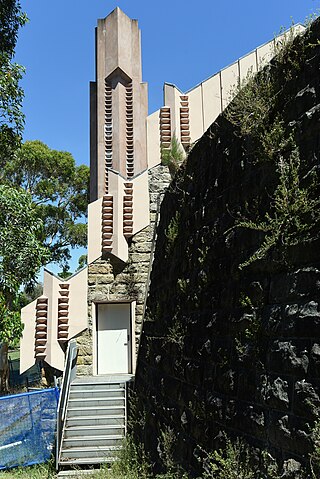
The Walter Burley Griffin Incinerator is a heritage-listed former incinerator and now art gallery, artists studios and public recreation area at 2 Small Street, Willoughby, City of Willoughby, Sydney, New South Wales, Australia. It was designed in partnership between Walter Burley Griffin and Eric Nicholls and built from 1933 to 1934 by Reverberatory Incinerator and Engineering Company and Nisson Leonard-Kanevsky. It is also known as Willoughby Municipal Incinerator. The property is owned by the Willoughby City Council. It was added to the New South Wales State Heritage Register on 2 April 1999.
References
- ↑ "Walter Burley Griffin Place District". City of Chicago Department of Planning and Development, Landmarks Division. 2003. Retrieved 2007-06-26.
41°42′14″N87°39′53″W / 41.7039°N 87.6646°W
| | This Chicago geographical article is a stub. You can help Wikipedia by expanding it. |