
The Ukrainian Village District is a landmark-designated district of residential buildings within the West Town community area of Chicago, Illinois. It was designated a Chicago Landmark in 2002, with area extensions in 2005 and 2007. [1] [2]
The Ukrainian Village District is a landmark-designated district of residential buildings within the West Town community area of Chicago, Illinois. It was designated a Chicago Landmark in 2002, with area extensions in 2005 and 2007. [1] [2]

The Ukrainian Village District was designated on December 4, 2002, and comprised portions of Haddon Avenue, Thomas Street, and Cortez Street between Damen and Leavitt Avenues, including portions of Damen, Hoyne and Leavitt Avenues. The district encompasses the oldest part of the Ukrainian Village neighborhood, which was developed beginning in the 1880s and lasting into the 1920s. In 1886, near the corner of Haddon Street and Damen Avenue, a group of distinctive brick workers cottages were begun by William D. Kerfoot (the first real estate developer to reestablish his business after the Great Chicago Fire of 1871). [1] [3]
The Walton Street Extension was designated on July 27, 2005 as a four-block stretch of Walton Street between Damen and Western Avenues. It is representative of the second phase of Ukrainian Village development, from 1890 to 1905. It contains an uninterrupted collection of solidly built workers cottages, single-family homes, and two- and three-flat residential buildings. This extension was not contiguous with the original district. [3]
A second Ukrainian Village District Extension was designated on April 11, 2007 with two distinct areas. The northerly part includes portions of Thomas Street, Cortez Street, and Augusta Boulevard between Leavitt Avenue and Oakley Boulevard, as well as Cortez from Oakley to Western, and Oakley between Thomas and Augusta. This area was divided into residential lots starting in 1905, and was built up with housing from 1910 to 1914. The southerly part includes Iowa Street from Hoyne to Western, Rice Street from Leavitt to Oakley, and Oakley from Walton to Rice. It was subdivided between 1908 and 1911, and built up with flats from 1910 to 1917. [3]
With the 2007 extension, the original district and its two extensions were made contiguous. They are collectively known as the Ukrainian Village District. Notably, although the congregation of the Saint Nicholas Ukrainian Catholic Cathedral at 2238 West Rice Street consented to the proposed designation, the congregation of Saint Volodymyr Ukrainian Orthodox Cathedral at 2252–2258 West Cortez Street did not; as a result the church building at the northeast corner of Cortez and Oakley, constructed ca. 1911 as the Evangelical Lutheran St. Peters Congregational Church, was exempted from the district. [2] [3]

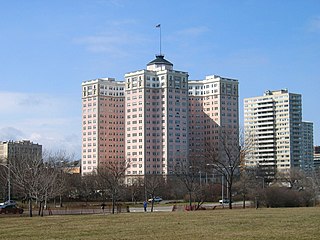
Riverside is a suburban village in Cook County, Illinois, United States. The population of the village was 9,298 at the 2020 census. It is a suburb of Chicago, located roughly 9 miles (14 km) west of downtown Chicago and 2 miles (3 km) outside city limits. A significant portion of the village is in the Riverside Landscape Architecture District, designated a National Historic Landmark in 1970.

Michigan Avenue is a north-south street in Chicago that runs at 100 east on the Chicago grid. The northern end of the street is at DuSable Lake Shore Drive on the shore of Lake Michigan in the Gold Coast Historic District. The street's southern terminus is at Sibley Boulevard in the southern suburb of Dolton, but like many other Chicago streets, it exists in several disjointed segments.

Streeterville is a neighborhood in the Near North Side community area of Chicago, Illinois, United States, north of the Chicago River. It is bounded by the river on the south, the Magnificent Mile portion of Michigan Avenue on the west, and Lake Michigan on the north and east, according to most sources, although the city of Chicago recognizes only a small portion of this region as Streeterville. Thus, it can be described as the Magnificent Mile plus all land east of it. The tourist attraction of Navy Pier and Ohio Street Beach extend out into the lake from southern Streeterville. To the north, the East Lake Shore Drive District, where the Drive curves around the shoreline, may be considered an extension of the Gold Coast. The majority of the land in this neighborhood is reclaimed sandbar.

Logan Square is an official community area, historical neighborhood, and public square on the northwest side of the City of Chicago. The Logan Square community area is one of the 77 city-designated community areas established for planning purposes. The Logan Square neighborhood, located within the Logan Square community area, is centered on the public square that serves as its namesake, located at the three-way intersection of Milwaukee Avenue, Logan Boulevard and Kedzie Boulevard.

West Town, northwest of the Loop on Chicago's West Side, is one of the city's officially designated community areas. Much of this area was historically part of Polish Downtown, along Western Avenue, which was then the city's western boundary. West Town was a collection of several distinct neighborhoods and the most populous community area until it was surpassed by Near West Side in the 1960s. The boundaries of the community area are the Chicago River to the east, the Union Pacific railroad tracks to the south, the former railroad tracks on Bloomingdale Avenue to the North, and an irregular western border to the west that includes the grand city park called Humboldt Park. Humboldt Park is also the name of the community area to West Town's west, Logan Square is to the north, Near North Side to the east, and Near West Side to the south. The collection of neighborhoods in West Town along with the neighborhoods of Bucktown and the eastern portion of Logan Square have been referred to by some media as the "Near Northwest Side".
The Bryn Mawr Historic District is on the lakefront of the Edgewater neighborhood of far-north Chicago, Illinois. It extends along Bryn Mawr Avenue between Broadway and Sheridan Road. Its most prominent features are the Belle Shore Apartment Hotel, Bryn Mawr Apartment Hotel, Edgewater Beach Apartments, Edgewater Presbyterian Church, Manor House, and the northernmost area of Lincoln Park.

Oak Street is a short street in Chicago's Gold Coast neighborhood, adjacent to North Michigan Avenue. Because the street houses the highest concentration of luxury brands, "Oak Street" also designates the surrounding area including Rush Street and Walton Street as Chicago's upscale retail district.
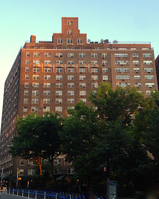
The West Village is a neighborhood in the western section of the larger Greenwich Village neighborhood of Lower Manhattan, New York City. The West Village is bounded by the Hudson River to the west and 14th Street to the north. The eastern boundary is variously cited as Greenwich Avenue, Seventh Avenue, or Sixth Avenue, while the southern boundary is either Houston Street or Christopher Street.

Wicker Park is a neighborhood in the West Town community area of the West Side of Chicago, Illinois, west of the Kennedy Expressway, east of Humboldt Park, and south of the Bloomingdale Trail, known for its hipster culture, art community, nightlife, and food scene.

Ukrainian Village is a Chicago neighborhood located on the near west side of Chicago. Its boundaries are Division Street to the north, Grand Avenue to the south, Western Avenue to the west, and Damen Avenue to the east. It is one of the neighborhoods in the West Town community area, and has one of the largest concentrations of Ukrainians in the United States, as the commercial and spiritual hub for nearly 70,000 Ukrainians in the greater Chicago region.
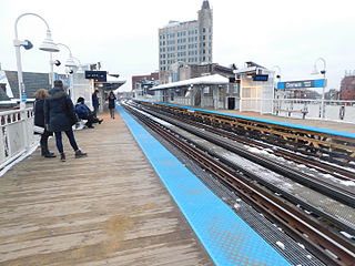
Damen is a rapid transit station on the Chicago "L", currently serving the O'Hare branch of its Blue Line. Opened on May 6, 1895, as Robey, it is the oldest station on the Blue Line. The station serves the popular Bucktown and Wicker Park neighborhoods, and is consistently in the top 40 highest-ridership "L" stations. It has two wooden side platforms and a brick station house at street level. The west platform, serving southbound trains, contains a tower that has never been used but is a relic of the station's past. The station is served by three bus routes on Damen, Milwaukee, and North Avenues, which are each descended from streetcar lines on those streets in the early 20th century. The Blue Line has owl service; while the surrounding streetcar lines also had owl service in the early 20th century, the modern bus services do not.

Washington Square, also known as Washington Square Park, is a park in Chicago, Illinois. A registered historic landmark that is better known by its nickname Bughouse Square, it was the most celebrated open air free-speech center in the country as well as a popular Chicago tourist attraction. It is located across Walton Street from Newberry Library at 901 N. Clark Street in the Near North Side community area of Chicago, Illinois, United States. It is Chicago's oldest existing small park. It is one of four Chicago Park District parks named after persons surnamed Washington. It was added to the National Register of Historic Places on May 20, 1991.

North Milwaukee Avenue is a street in the city of Chicago and the northern suburbs.

The Wicker Park District is a historic district in the West Town community area of Chicago, Illinois. It is the neighborhood bounded by Bell Avenue, Caton Street, Leavitt Street, Potomac Avenue and Chicago 'L' tracks. It was designated a Chicago Landmark on April 12, 1991.

Cortez Hill is a neighborhood in the northeast part of downtown San Diego, California.

The Iglehart House is an Italianate style house in the Morgan Park neighborhood of Chicago, Illinois, United States, and one of the city's oldest surviving buildings.

The South Village is a largely residential area that is part of the larger Greenwich Village in Lower Manhattan, New York City, directly below Washington Square Park. Known for its immigrant heritage and bohemian history, the architecture of the South Village is primarily tenement-style apartment buildings, indicative of the area's history as an enclave for Italian-American immigrants and working-class residents of New York.
The Humboldt Park branch was a rapid transit line which was part of the Chicago "L" system from 1895 to 1952. The branch served the West Town and the Humboldt Park neighborhoods of Chicago and consisted of six elevated stations. It opened on July 29, 1895, and closed on May 4, 1952.
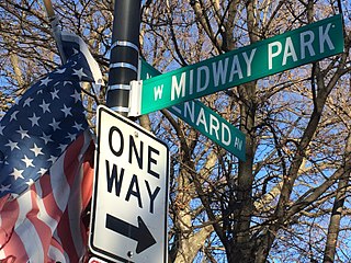
Midway Park is a sub-neighborhood of Austin in Chicago, Illinois. This Chicago landmark district lies both north and south of Lake Avenue. The northerly section is bounded by West Lake Street, West Ohio Street, North Waller Avenue and North Austin Street. The southerly portion runs north from West End Avenue to Corcoran Place and west from Parkside Avenue to Menard Avenue.