Washington Park Court District

Last updated

Washington Park Court
S Washington Park Ct Chicago.svg
20090101 Washington Park Court District Map.png
Maintained by Department of Streets & Sanitation
Location Chicago
North endEast 49th Street (one-way east)
Major
junctions
East 50th Street (hosts additional contributing properties. [1] )
South endEast 50th Street (one-way west)
Washington Park Court from the south (November 1, 2009) 20090111 Washington Park Court from 50th St..JPG
Washington Park Court from the south (November 1, 2009)

The Washington Park Court District is a Grand Boulevard community area neighborhood on the South Side of Chicago, Illinois. It was designated a Chicago Landmark on October 2, 1991. [2] Despite its name, it is not located within either the Washington Park community area or the Washington Park park, but is one block north of both. The district was named for the Park. [3]

Contents

The district includes row houses built between 1895 and 1905, with addresses of 49004959 South Washington Park Court and 417439 East 50th Street. [2] Many of the houses share architectural features. [4] The neighborhood was part of the early twentieth century segregationist racial covenant wave that swept Chicago following the Great Migration. [5] The community area has continued to be almost exclusively African American since the 1930s. [6]

Architecture

Washington Park Court District
20090111 Washington Park Court from 49th St..JPG
20090111 50th St in Washington Park Court District.JPG
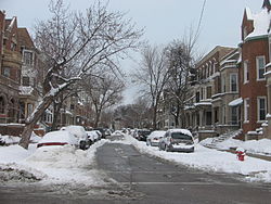
Top: Washington Park Court from north; Bottom: 50th St in Washington Park Court District

Washington Park Court, which runs one-way northbound from East 50th Street to East 49th Street, is a one-city block-long street located at 432 east in the Chicago street numbering system. Officially, it runs from 4900 south to 5060 south in the numbering system. [3] The street and several adjacent homes at one end are recognized as a distinct district within the city, according to the City of Chicago Department of Planning and Development. [2] In May 1990, the district was one of ten that were under consideration for Chicago Landmark status, [7] and it was designated a Chicago Landmark on October 2, 1991. [2] The district was named for the Park, [3] which was designed by landscape architect Frederick Law Olmsted. [8]

The T. G. Dickinson Real Estate Company, which created the subdivision in 1892, mandated 10-foot (3.0 m) setbacks for all properties and originally sold lots in small groups of two or three. [4] Between 1895 and 1905, the tone of the district became clear with the development of its row houses. [2] [4] In 1990, the district contained forty-nine row houses that span a wide variety of architectural styles including Classical Revival and Romanesque. [7] As of 2004, the district contained fifty-one properties. [4] The street hosts residential designs of architect Henry Newhouse and of developers Andrew and John Dubach. [2] At least twenty-five of the lots were developed by the Dubaches and at least twelve of the properties were designed by Newhouse. [4] Their architectural contributions set the tone for the block, which uses mostly brick and limestone houses that share porch and cornice lines. [4] Most houses have mansards or recessed roofs with bay fronts. [4]

Demographic change

Between 1900 and 1934 the African American population in Chicago grew from 30,000 to 236,000. [9] The population was initially diluted in scattered places, but during this time, due to the change in the demographics of Chicago, it became concentrated in two large strips of land. [9] The racial concentration was enforced by violence for few decades, until restrictive covenants became the preferred way to enforce segregation. [9] Although they were previously rare, racially restrictive covenants among property owners that outlawed the purchase, lease, or occupation of their properties by African Americans became common in Chicago in the 1920s following the Great Migration, [10] especially after the 1926 United States Supreme Court upheld racially restrictive covenants in Corrigan v. Buckley (271 U.S. 323 (1926)). [9] [10]

During the first half of the 20th century, The Black Belt was the term for the African-American neighborhood from 22nd Street to 31st Street along State Street on Chicago's South Side. [11] South Side local businessmen and the University of Chicago became alarmed at the prospect of poorer blacks moving from the Black Belt due to a combination of racial succession and economic decline. [12] Because 85% of Chicago was covenanted, most black neighborhoods were bounded by covenanted areas. [9] The Washington Park Court Improvement Association changed its focus from neighborhood improvement projects, such as planting shrubs and cleaning streets, to upholding segregationist policies. [5] [13] When necessary, the organization resorted to violence to pursue its segregationist purpose, and between 1917 and 1921, bombs were used to discourage encroachment into majority white neighborhoods. The bombs were used at the residences of African Americans as well as the properties of real estate agents and bankers. [5]

Eventually the term Black Belt included the region from 39th Street to 95th Street between the Dan Ryan Expressway and Lake Michigan. [11] Since the 1930 United States Census, the Grand Boulevard community area has been over 90% African American. In both the 1960 and 1990 Census, the community area was over 99% African American. As of the 2000 Census, the area was 98.2% African American and 0.8% Hispanic. [6]

Notes

  1. "Washington Park Court District Map". City of Chicago Department of Planning and Development, Landmarks Division. 2003. Retrieved January 2, 2009.
  2. 1 2 3 4 5 6 "Washington Park Court District". City of Chicago Department of Planning and Development, Landmarks Division. 2003. Retrieved March 30, 2007.
  3. 1 2 3 Hayner, Don and Tom McNamee, Streetwise Chicago, "Washington Park Court", p. 130, Loyola University Press, 1988, ISBN   0-8294-0597-6
  4. 1 2 3 4 5 6 7 Sinkevitch, Alice, ed. (2004). "Oakland/Kenwood: Washington Park Court: S. Washington Park Ct. from 49th to 50th Sts.". AIA Guide to Chicago (2nd ed.). Harcourt, Inc. p. 415. ISBN   0-15-602908-1 . Retrieved January 4, 2008.
  5. 1 2 3 Washington, Sylvia Hood (2005). "Planning and Environmental Inequality". Packing Them In: An Archaeology of Environmental Racism in Chicago, 18651954 . Lexington Books. p.  140. ISBN   0-7391-1029-2 . Retrieved January 3, 2009. Washington Park Court.
  6. 1 2 Best, Wallace (2005). "Grand Boulevard". The Electronic Encyclopedia of Chicago. Chicago Historical Society . Retrieved February 14, 2009.
  7. 1 2 Busk, Celeste (May 11, 1990). "Ten city sites are targeted for landmark status". Chicago Sun-Times . Newsbank . Retrieved January 2, 2009.
  8. Bachin, Robin (2005). "Washington Park (Park)". The Encyclopedia of Chicago. Chicago Historical Society . Retrieved February 14, 2009.
  9. 1 2 3 4 5 Kamp, Allen R. (1986–1987). "The History Behind Hansberry v. Lee" (PDF). UC Davis Law Review. 20. University of California, Davis: 481–500. Archived from the original (PDF) on June 12, 2010. Retrieved January 2, 2009.
  10. 1 2 Hirsch, Arnold R. (2005). "Restrictive Covenants". The Electronic Encyclopedia of Chicago. Chicago Historical Society . Retrieved December 31, 2008.
  11. 1 2 Best, Wallace (2005). "Black Belt". The Electronic Encyclopedia of Chicago. Chicago Historical Society . Retrieved February 14, 2009.
  12. Seligman, Amanda (2005). "Woodlawn". The Electronic Encyclopedia of Chicago. Chicago Historical Society . Retrieved December 31, 2008.
  13. Myrdal, Gunnar and Sissela Bok (1996). An American Dilemma: The Negro Problem and Modern Democracy, Vol. 2. Transaction Publishers. ISBN   978-1-56000-857-6 . Retrieved January 4, 2008.

41°41′30″N87°36′37″W / 41.691598°N 87.610302°W / 41.691598; -87.610302

Related Research Articles

<span class="mw-page-title-main">Hyde Park, Chicago</span> Community area of Chicago

Hyde Park is a neighborhood on the South Side of Chicago, Illinois, located on and near the shore of Lake Michigan 7 miles (11 km) south of the Loop. It is one of the city's 77 municipally recognized community areas.

<span class="mw-page-title-main">Washington Park (community area), Chicago</span> Community area in Chicago

Washington Park is a community area on the South Side of Chicago which includes the 372 acre (1.5 km2) park of the same name, stretching east-west from Cottage Grove Avenue to the Dan Ryan Expressway, and north-south from 51st Street to 63rd. It is home to the DuSable Museum of African American History. The park was the proposed site of the Olympic Stadium and the Olympic Aquatics Center in Chicago's bid to host the 2016 Summer Olympics.

<span class="mw-page-title-main">South Shore, Chicago</span> Community area in Chicago

South Shore is one of 77 defined community areas of Chicago, Illinois, United States. Located on the city's South Side, the area is named for its location along the city's southern lakefront. Although South Shore has seen a greater than 40% decrease in residents since Chicago's population peaked in the 1950s, the area remains one of the most densely populated neighborhoods on the South Side. The community benefits from its location along the waterfront, its accessibility to Lake Shore Drive, and its proximity to major institutions and attractions such as the University of Chicago, the Museum of Science and Industry, and Jackson Park.

<span class="mw-page-title-main">Central District, Seattle</span> Seattle Neighborhood in King, Washington, United States

The Central Area, commonly called the Central District or The CD, is a mostly residential district in Seattle located east of downtown and First Hill ; west of Madrona, Leschi and Mt. Baker; south of Capitol Hill, and north of Rainier Valley. Historically, the Central District has been one of Seattle's most racially and ethnically diverse neighborhoods, and was once the center of Seattle's black community and a major hub of African-American businesses.

<span class="mw-page-title-main">Oakland, Chicago</span> Community area in Chicago

Oakland, located on the South Side of Chicago, Illinois, USA, is one of 77 officially designated Chicago community areas. Bordered by 35th and 43rd Streets, Cottage Grove Avenue and Lake Shore Drive, The Oakland area was constructed between 1872 and 1905. Some of Chicago's great old homes may be seen on Drexel Boulevard. The late 19th-century Monument Baptist Church on Oakwood Blvd. is modeled after Boston's Trinity Church. Oakwood/41st Street Beach in Burnham Park is at 4100 S. Lake Shore Drive. With an area of only 0.6 sq mi Oakland is the smallest community area by area in Chicago.

<span class="mw-page-title-main">Grand Boulevard, Chicago</span> Community area in Chicago

Grand Boulevard on the South Side of Chicago, Illinois, is one of the city's Community Areas. The boulevard from which it takes its name is now Martin Luther King Jr. Drive. The area is bounded by 39th to the north, 51st Street to the south, Cottage Grove Avenue to the east, and the Chicago, Rock Island & Pacific Railroad tracks to the west.

<span class="mw-page-title-main">West Englewood, Chicago</span> Community area in Chicago

West Englewood, one of the 77 community areas, is on the southwest side of Chicago, Illinois. At one time it was known as South Lynne. The boundaries of West Englewood are Garfield Blvd to the north, Racine Ave to the east, the CSX and Norfolk Southern railroad tracks to the west, and the Belt Railway of Chicago to the south. Though it is a separate community area, much of the history and culture of the neighborhood is linked directly to the Englewood neighborhood.

A covenant, in its most general sense and historical sense, is a solemn promise to engage in or refrain from a specified action. Under historical English common law, a covenant was distinguished from an ordinary contract by the presence of a seal. Because the presence of a seal indicated an unusual solemnity in the promises made in a covenant, the common law would enforce a covenant even in the absence of consideration. In United States contract law, an implied covenant of good faith is presumed.

<span class="mw-page-title-main">History of African Americans in Chicago</span> Ethnic group

The history of African Americans in Chicago or Black Chicagoans dates back to Jean Baptiste Point du Sable's trading activities in the 1780s. Du Sable, the city's founder, was Haitian of African and French descent. Fugitive slaves and freedmen established the city's first black community in the 1840s. By the late 19th century, the first black person had been elected to office.

<span class="mw-page-title-main">Paul Cornell (lawyer)</span> American lawyer; Investor

Paul Cornell was an American lawyer and Chicago real estate speculator who founded the Hyde Park Township that included most of what are now known as the south and far southeast sides of Chicago in Cook County, Illinois, United States. He turned the south side Lake Michigan lakefront area, especially the Hyde Park community area and neighboring Kenwood and Woodlawn neighborhoods, into a resort community that had its heyday from the 1850s through the early 20th century. He was also an urban planner who paved the way for and preserved many of the parks that are now in the Chicago Park District. Additionally, he was a successful entrepreneur with interests in manufacturing, cemeteries, and hotels.

<span class="mw-page-title-main">Washington Park Subdivision</span> Historic subdivision in Chicago, Illinois

The Washington Park Subdivision is the name of the historic 3-city block by 4-city block subdivision in the northwest corner of the Woodlawn community area, on the South Side of Chicago in Illinois that stands in the place of the original Washington Park Race Track. The area evolved as a redevelopment of the land previously occupied by the racetrack. It was originally an exclusively white neighborhood that included residential housing, amusement parks, and beer gardens.

The neighborhoods of Omaha are a diverse collection of community areas and specific enclaves. They are spread throughout the Omaha metro area, and are all on the Nebraska side of the Missouri River.

<span class="mw-page-title-main">South Side, Chicago</span> Area of the city of Chicago, Illinois, US

The South Side is one of the three major sections of the city of Chicago, Illinois, United States. Geographically, it is the largest of the three sections of the city, with the other two being the North and West Sides. It radiates and lies south of the city's downtown area, the Chicago Loop.

<span class="mw-page-title-main">Coldstream-Homestead-Montebello, Baltimore</span> Neighborhood in Baltimore, Maryland

The Coldstream-Homestead-Montebello community, often abbreviated to C-H-M, is a neighborhood in northeastern Baltimore, Maryland. A portion of the neighborhood has been listed on the National Register of Historic Places as the Coldstream Homestead Montebello Historic District, recognized for the development of a more suburban style of rowhouses.

<span class="mw-page-title-main">Broadway–Flushing, Queens</span> Neighborhood in New York City

Broadway–Flushing is a historic district and residential subsection of Flushing, Queens, New York City. The neighborhood comprises approximately 2,300 homes. It is located between 155th and 170th Streets to the west and east respectively, and is bounded on the north by Bayside and 29th Avenues, and on the south by Northern Boulevard and Crocheron Avenue. Broadway–Flushing is listed on the National Register of Historic Places.

<span class="mw-page-title-main">Strivers' Section Historic District</span> Historic district in Washington, D.C., United States

The Strivers' Section Historic District is a historic district located in the Dupont Circle neighborhood of Washington, D.C. Strivers' Section was historically an enclave of upper-middle-class African Americans, often community leaders, in the late 19th and early 20th centuries. It takes its name from a turn-of-the-20th-century writer who described the district as "the Striver's section, a community of Negro aristocracy." The name echoes that of Strivers' Row in Harlem, a New York City historic neighborhood of black professionals. The district is roughly bounded by Swann Street and the Dupont Circle Historic District on the south, Florida Avenue and the Washington Heights Historic District on the north and west, and the Sixteenth Street Historic District on the east.

<span class="mw-page-title-main">Prairie Avenue</span> Thoroughfare in Chicago, United States

Prairie Avenue is a north–south street on the South Side of Chicago, which historically extended from 16th Street in the Near South Side to the city's southern limits and beyond. The street has a rich history from its origins as a major trail for horseback riders and carriages. During the last three decades of the 19th century, a six-block section of the street served as the residence of many of Chicago's elite families and an additional four-block section was also known for grand homes. The upper six-block section includes part of the historic Prairie Avenue District, which was declared a Chicago Landmark and added to the National Register of Historic Places.

Corrigan v. Buckley, 271 U.S. 323 (1926), was a US Supreme Court case in 1926 that ruled that the racially-restrictive covenant of multiple residents on S Street NW, between 18th Street and New Hampshire Avenue, in Washington, DC, was a legally-binding document that made the selling of a house to a black family a void contract. This ruling set the precedent upholding racially restrictive covenants in Washington; soon after this ruling, racially restrictive covenants flourished around the nation. Subsequently, in Shelley v. Kraemer (1948) the court reconsidered such covenants and found that racially restrictive covenants are unenforceable.

<span class="mw-page-title-main">West Adams Heights, Los Angeles</span> Neighborhood of Los Angeles in California, United States of America

West Adams Heights is a neighborhood in Central Los Angeles, California. It contains three Los Angeles Historic-Cultural Monuments.