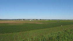
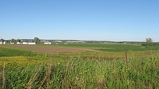
Kaskaskia is a village in Randolph County, Illinois. Having been inhabited by indigenous peoples, it was settled by France as part of the Illinois Country. It was named for the Kaskaskia people. Its population peaked at about 7,000 in the 18th century, when it was a regional center. During the American Revolutionary War, the town, which by then had become an administrative center for the British Province of Quebec, was taken by the Virginia militia during the Illinois campaign. It was designated as the county seat of Illinois County, Virginia, after which it became part of the Northwest Territory in 1787. Kaskaskia was later named as the capital of the United States' Illinois Territory, created on February 3, 1809. In 1818, when Illinois became the 21st U.S. state, the town briefly served as the state's first capital until 1819, when the capital was moved to more centrally located Vandalia.

Cahokia was a village in St. Clair County, Illinois, United States. It was located east of the Mississippi River in the Greater St. Louis metropolitan area. As of the 2010 census, 15,241 people lived in the village, a decline from 16,391 in 2000. On May 6, 2021, the village ceased to exist, being incorporated into the new city of Cahokia Heights.
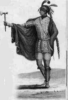
The Kaskaskia were one of the indigenous peoples of the Northeastern Woodlands. They were one of about a dozen cognate tribes that made up the Illiniwek Confederation, also called the Illinois Confederation. Their longstanding homeland was in the Great Lakes region. Their first contact with Europeans reportedly occurred near present-day Green Bay, Wisconsin, in 1667 at a Jesuit mission station.

The Illinois Country —sometimes referred to as Upper Louisiana —was a vast region of New France claimed in the 1600s in what is now the Midwestern United States. While those names generally referred to the entire Upper Mississippi River watershed, French colonial settlement was concentrated along the Mississippi and Illinois Rivers in what is now the U.S. states of Illinois and Missouri, with outposts on the Wabash River in Indiana. Explored in 1673 from Green Bay to the Arkansas River by the Canadien expedition of Louis Jolliet and Jacques Marquette, the area was claimed by France. It was settled primarily from the Pays d'en Haut in the context of the fur trade, and in the establishment of missions by French Catholic religious orders. Over time, the fur trade took some French to the far reaches of the Rocky Mountains, especially along the branches of the broad Missouri River valley. The French name, Pays des Ilinois, means "Land of the Illinois [plural]" and is a reference to the Illinois Confederation, a group of related Algonquian native peoples.

Starved Rock State Park is a state park in the U.S. state of Illinois, characterized by the many canyons within its 2,630 acres (1,064 ha). Located just southeast of the village of Utica, in Deer Park Township, LaSalle County, Illinois, along the south bank of the Illinois River, the park hosts over two million visitors annually, the most for any Illinois state park.

Fort de Chartres was a French fortification first built in 1720 on the east bank of the Mississippi River in present-day Illinois. It was used as the administrative center for the province, which was part of New France. Due generally to river floods, the fort was rebuilt twice, the last time in limestone in the 1750s in the era of French colonial control over Louisiana and the Illinois Country.

The American Bottom is the flood plain of the Mississippi River in the Metro-East region of Southern Illinois, extending from Alton, Illinois, south to the Kaskaskia River. It is also sometimes called "American Bottoms". The area is about 175 square miles (450 km2), mostly protected from flooding in the 21st century by a levee and drainage canal system. Immediately across the river from St. Louis, Missouri, are industrial and urban areas, but nearby marshland, swamps, and the Horseshoe Lake are reminders of the Bottoms' riparian nature.

Fort Massac is a French colonial and early National-era fort on the Ohio River in Massac County, Illinois.
The Illinois Historic Preservation Division, formerly Illinois Historic Preservation Agency, is a governmental agency of the U.S. state of Illinois, and is a division of the Illinois Department of Natural Resources. It is tasked with the duty of maintaining State-owned historic sites, and maximizing their educational and recreational value to visitors or on-line users. In addition, it manages the process for applications within the state for additions to the National Register of Historic Places.

The Grand Village of the Illinois, also called Old Kaskaskia Village, is a site significant for being the best documented historic Native American village in the Illinois River valley. It was a large agricultural and trading village of Native Americans of the Illinois confederacy, located on the north bank of the Illinois River near the present town of Utica, Illinois. French explorers Louis Joliet and Father Jacques Marquette came across it in 1673. The Kaskaskia, a tribe of the Illiniwek people lived in the village. It grew rapidly after a French mission and fur trading post were established there in 1675, to a population of about 6,000 people in about 460 houses. Around 1691 the Kaskaskia and other Illiniwek moved further south, abandoning the site due to pressure from an Iroquois invasion from the northeast.
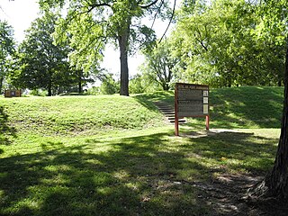
Fort Kaskaskia State Historic Site is a 200-acre (0.8 km²) park near Chester, Illinois, on a blufftop overlooking the Mississippi River. It commemorates the vanished frontier town of Old Kaskaskia and the support it gave to George Rogers Clark in the American Revolution.

The Cahokia Courthouse State Historic Site is a reconstructed French-Canadian structure built about 1740 at what is now 107 Elm Street, Cahokia Heights, Illinois. At various times it has served as a house and as a courthouse. It is currently interpreted to resemble its appearance about 1800 as a frontier courthouse of the Northwest Territory. The courthouse was listed on the National Register of Historic Places on November 9, 1972.

Felix St. Vrain, born Felix August Antoine St. Vrain, was an American United States Indian agent who was killed by Native Americans during the Black Hawk War. St. Vrain died along with three companions while on a mission to deliver dispatches from Dixon's Ferry to Fort Armstrong, both in Illinois. The incident has become known as the St. Vrain massacre.

The Crailo State Historic Site is a historic, fortified brick manor house in Rensselaer, New York which was built in 1707. The word Crailo is derived from kraaien bos and refers to Kiliaen van Rensselaer's estate in Huizen, Holland, which is also named "Crailo". Fort Crailo is listed on the National Register of Historic Places.

The Pierre Menard House, located in Ellis Grove, Illinois, U.S.A., was the home of Pierre Menard, a trader who became the first lieutenant governor of Illinois from 1818 to 1822.

The Peterstown House is a historic building located in Waterloo, Illinois. The saltbox building was constructed in the mid-1830s; an addition was placed on its north side around the 1860s. Emory Peter Rogers, for whom the house and surrounding neighborhood were named, was the first owner of the building. The building served as an inn and stagecoach stop along the Kaskaskia-Cahokia Trail, which was the first road in Illinois. The stagecoach route connected the French settlements at Kaskaskia and Cahokia. The Peterstown House is the only intact inn which still stands along the trail; while another building in Waterloo once served as an inn on the trail, it has been extensively remodeled. In the late nineteenth century, the Peterstown House became a local social hall.

The Ste. Genevieve National Historical Park, established in 2020, consists of part or the whole of the area of the Ste. Genevieve Historic District, which is a historic district encompassing much of the built environment of Ste. Genevieve, Missouri, United States. The city was in the late 18th century the capital of Spanish Louisiana, and, at its original location a few miles south, capital of French Louisiana as well. A large area of the city, including fields along the Mississippi River, is a National Historic Landmark District designated in 1960, for its historically French architecture and land-use patterns, while a smaller area, encompassing the parts of the city historically important between about 1790 and 1950, was named separately to the National Register of Historic Places in 2002.

The Creole House is a historic residence in the village of Prairie du Rocher, an old French settlement in present-day Randolph County, Illinois, United States. Built at the end of the eighteenth century and later expanded, the Creole House is the last survivor in Illinois of its type of vernacular architecture, and it forms an important part of the built environment of a portion of the Upper Mississippi Valley that possesses an unparalleled connection to the French settlement period.
The Kolmer Site is an archaeological site in the far southwest of the U.S. state of Illinois. Located near Kaskaskia and Prairie du Rocher in western Randolph County, it lies at the site of an early historic Indian village from the French period. Because it occupies a critical chronological and cultural position, it has been given national recognition as a historic site.