
The Hopewell tradition, also called the Hopewell culture and Hopewellian exchange, describes a network of precontact Native American cultures that flourished in settlements along rivers in the northeastern and midwestern Eastern Woodlands from 100 BCE to 500 CE, in the Middle Woodland period. The Hopewell tradition was not a single culture or society but a widely dispersed set of populations connected by a common network of trade routes.


The Angono - Binangonan Petroglyphs are petroglyphs carved into a rock wall in Binangonan, Rizal, Philippines. It consists of 127 human and animal figures engraved on the rockwall probably carved during the late Neolithic, or before 2000 BC. They are the oldest known work of art in the Philippines. These inscriptions clearly show stylized human figures, frogs and lizards, along with other designs that may have depicted other interesting figures but erosion may have caused it to become indistinguishable. The engravings are mostly symbolic representations and are associated with healing and sympathetic magic.

The Grand Village of the Illinois, also called Old Kaskaskia Village, is a site significant for being the best documented historic Native American village in the Illinois River valley. It was a large agricultural and trading village of Native Americans of the Illinois confederacy, located on the north bank of the Illinois River near the present town of Utica, Illinois. French explorers Louis Joliet and Father Jacques Marquette came across it in 1673. The Kaskaskia, a tribe of the Illiniwek people lived in the village. It grew rapidly after a French mission and fur trading post were established there in 1675, to a population of about 6,000 people in about 460 houses. Around 1691 the Kaskaskia and other Illiniwek moved further south, abandoning the site due to pressure from an Iroquois invasion from the northeast.

Sanilac Petroglyphs Historic State Park is a state park in the U.S. state of Michigan. The park, also known as ezhibiigadek asin consists of 240 acres (97 ha) in Greenleaf Township, Sanilac County, in Michigan's Thumb. It contains the largest collection of Native American petroglyphs in Michigan. The carvings were created in the pre-Columbian era and represent aspects of Native American spirituality. An interpretive hiking trail within the park passes along the nearby Cass River.

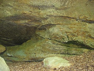
The Modoc Rock Shelter is a rock shelter or overhang located beneath the sandstone bluffs that form the eastern border of the Mississippi River floodplain at which Native American peoples lived for thousands of years. This site is significant for its archaeological evidence of thousands of years of human habitation during the Archaic period in the Eastern United States. It is located on the northeastern side of County Road 7 southeast of Prairie du Rocher in Randolph County, Illinois, United States. It was declared a National Historic Landmark in 1961.

The Greaser Petroglyph Site is located on land managed by the Bureau of Land Management in eastern Lake County, Oregon. The designs were scraped into a basalt boulder by Native Americans perhaps 12,000 years ago. No one knows the meaning of the designs. Because of its unique archaeological and cultural significance, the Greaser Petroglyph Site was listed on the National Register of Historic Places in 1974.

The Barnesville Petroglyph petroglyph site in the eastern part of the U.S. state of Ohio. Located approximately 3 miles (4.8 km) southwest of the village of Barnesville in Belmont County, the petroglyphs have been known both by archaeologists and the general public since the 1850s or earlier. Although the site was significantly damaged during the twentieth century, it is still a significant archaeological site, and has been named a historic site.

Indian God Rock is a large boulder in the northwestern part of the U.S. state of Pennsylvania. Located near the unincorporated community of Brandon, it lies along the Allegheny River in Venango County's Rockland Township. It is significant for the large petroglyph on one of its sides. Because of the petroglyph, the rock has been an explorers' landmark, a tourist attraction, and an object of scholarly investigation.

The Francis Farm Petroglyphs are a group of petroglyphs in the southwestern part of the U.S. state of Pennsylvania. Located on a boulder in Jefferson Township in the northwestern portion of Fayette County, it has been known to archaeologists since at least the middle of the nineteenth century. Despite damage in the 1930s, it remains an important archaeological site, and accordingly, it has been designated a historic site.

The Sugar Grove Petroglyphs are a group of petroglyphs in the southwestern part of the U.S. state of Pennsylvania. Located on an outcrop of sandstone in Monongahela Township near the eastern edge of Greene County, the petroglyphs have been known since at least the 1930s. Due to their value as an archaeological site, the petroglyphs have been named a historic site.

Judaculla Rock is a curvilinear-shaped outcrop of soapstone known for its ancient carvings and petroglyphs. The archaeological site is located on a 0.85-acre rectangular-shaped property, now owned by Jackson County. It is approximately 60 meters east of Caney Fork Creek, a major branch of the northwestward-trending Tuckasegee River in the mountains of Western North Carolina.

The Picture Rock Pass Petroglyphs Site is in northern Lake County, Oregon, United States. The site is located near the summit of Picture Rock Pass on land administered by the Bureau of Land Management. The designs were scraped into a basalt boulder by ancient Native Americans, probably between 7,500 and 12,000 years ago. No one knows the meaning of the petroglyph designs. Because of its unique archaeological and cultural significance, the Picture Rock Pass Petroglyph Site was listed on the National Register of Historic Places in 1975.

The Deer Valley Petroglyph Preserve, formerly known as the Deer Valley Rock Art Center, is a 47-acre nature preserve featuring over 1500 Hohokam, Patayan, and Archaic petroglyphs visible on 500 basalt boulders in the Deer Valley area of Phoenix, Arizona. In 1980, the US Army Corps of Engineers contracted Simon J. Bruder to conduct an archaeological investigation prior to the construction of the Adobe Dam at the Hedgpeth Hills. The petroglyphs are between 500 and 5,000 years old. The site was listed on the National Register of Historic Places in 1984, and it was also listed with the Phoenix Points of Pride. The preserve and museum are operated by the ASU College of Liberal Arts and Sciences's School of Human Evolution and Social Change.

The Piney Creek Site is a prehistoric rock art site located on the north side of Piney Creek in Piney Creek Ravine State Natural Area in Randolph County, Illinois. The site consists of a sandstone outcropping with over 150 petroglyph and pictograph designs, the most at a single known site in Illinois. The designs are divided into four distinct groups; three of these are on the center and ends of the rock shelter's wall, while the fourth is on a joint block of sandstone within the shelter. Most of the designs were created during the Late Woodland and Mississippian periods, which spanned from 450 to 1550 A.D.; a number of the figures were added after 1550. A 1 metre tall spear-holding anthropomorph in the western group is the largest individual petroglyph in Illinois. In addition to anthropomorphs, other common designs at the site include zoomorphs, quadrupeds which probably represent deer, and symbols; the quadrupeds and anthropomorphs are frequently depicted in motion. The rock shelter was likely used as a religious site by prehistoric inhabitants, and several of the designs appear to have mystical or spiritual significance; for instance, the winged anthropomorphs likely represent shamans.

The Piney Creek South Site is a prehistoric rock art site located on the south side of Piney Creek in Piney Creek Ravine State Natural Area in Randolph County, Illinois. The site consists of two groups of petroglyphs drawn on a sandstone rockshelter. The petroglyphs most likely date from the Late Woodland period, which lasted from 450 to 900 A.D. The larger petroglyph group contains ten designs: four anthropomorphs, a quadruped resembling a deer, three crosses, and two pits. The four designs in the smaller group include two anthropomorphs, a group of pits extending from an anthropomorph's head, and a pecked area. Several of the anthropomorphs appear to have wings, two are carrying shields or rattles, one appears to have a beak, and one may have a crude penis. The site likely had spiritual significance, and the anthropomorphs may represent shamans, who were frequently depicted with wings in Native American art.
The Piney Creek West Site is a prehistoric rock art site located north of Piney Creek in Piney Creek Ravine State Natural Area in Randolph County, Illinois. The site consists of four petroglyphs painted on the inside of a rock shelter and a pictograph painted on the outside. The interior petroglyphs include an abstract shape, two curved lines, and a serpentine line with a pit at one end; two of the petroglyphs are filled in with ochre pigment, representing the only intact example of this painting technique in Illinois. The pictograph, which has deteriorated badly, depicts a human left hand; nearby flecks of paint from an unrecognizably faded figure likely indicate the site of the right hand. The paintings were likely added during the Late Woodland period, which lasted from 450 to 900 A.D. The serpentine figure inside the shelter suggests that the site had spiritual significance, as it resembles other prehistoric rock art depicting shamanic trance states.

The Tegtmeyer Site is a prehistoric rock art site located north of Piney Creek in Piney Creek Ravine State Natural Area in Randolph County, Illinois. The site consists of two petroglyphs painted on a sandstone rock shelter. One petroglyph depicts a winged anthropomorph in flight, while the other depicts a winged zoomorph which may also be flying. Based on their similarity to other sites from the period, the petroglyphs at the site most likely date from the Mississippian period. The petroglyphs resemble some of the figures painted at the nearby Piney Creek Site; given that the Tegtmeyer Site was unsuitable for inhabitation, it was most likely used for additional paintings which could not fit at the Piney Creek Site.

Tainter Cave, also known as Tombstone Cave, is a dry sandstone cave in Crawford County, Wisconsin, in which prehistoric Native Americans carved petroglyphs and drew pictographs, including birds, men, deer, and abstract designs. With over 100 pictographs, the cave holds more than any other known site in Wisconsin. It is also notable as the first archaeological site recorded in the dark zone of a cave in the Upper Midwest.
The Carcajou Point site is located in Jefferson County, Wisconsin, on Lake Koshkonong. It is a multi-component site with prehistoric Upper Mississippian Oneota and Historic components.
