Westervelt, Illinois | |
|---|---|
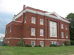 Westervelt Christian Church | |
 Westervelt, Illinois | |
| Coordinates: 39°28′45″N88°51′40″W / 39.47917°N 88.86111°W [1] | |
| Country | United States |
| State | Illinois |
| County | Shelby |
| Township | Ridge |
| Area | |
• Total | 0.09 sq mi (0.22 km2) |
| • Land | 0.09 sq mi (0.22 km2) |
| • Water | 0.00 sq mi (0.00 km2) |
| Elevation | 650 ft (200 m) |
| Population (2020) | |
• Total | 131 |
| • Density | 1,523.26/sq mi (591.04/km2) |
| Time zone | UTC-6 (Central (CST)) |
| • Summer (DST) | UTC-5 (CDT) |
| ZIP Code | 62565 |
| Area code | 217 |
| GNIS feature ID | 2628563 [1] |
Westervelt is a census-designated place in Shelby County, Illinois, United States. [1] Its population was 131 as of the 2020 census. [3]
