
The Financial District of Lower Manhattan, also known as FiDi, is a neighborhood located on the southern tip of Manhattan island in New York City. It is bounded by the West Side Highway on the west, Chambers Street and City Hall Park on the north, Brooklyn Bridge on the northeast, the East River to the southeast, and South Ferry and the Battery on the south.

Federal Hill is a neighborhood in Baltimore, Maryland, United States that lies just to the south of the city's central business district. Many of the structures are included in the Federal Hill Historic District, listed on the National Register of Historic Places in 1970. Other structures are included in the Federal Hill South Historic District, listed in 2003.

Chatham is one of the 77 community areas of the city of Chicago, Illinois. It is located on the city's South Side. It includes the neighborhoods of Chatham-Avalon, Chatham Club, Chesterfield, East Chatham, West Chatham and the northern portion of West Chesterfield. Its residents are predominantly African American, and it is home to former Senator Roland Burris. Housing many city employees and other officials, Chatham has been a central area for Chicago's middle-class African Americans since the late 1950s.

Canton is a historic waterfront neighborhood in Baltimore, Maryland, United States. The neighborhood is along Baltimore's outer harbor in the southeastern section of the city, roughly two miles east of Baltimore's downtown district and next to or near the neighborhoods of Patterson Park, Fell's Point, Highlandtown, and Brewers Hill.

The Grand Concourse is a 5.2-mile-long (8.4 km) thoroughfare in the borough of the Bronx in New York City. Grand Concourse runs through several neighborhoods, including Bedford Park, Concourse, Highbridge, Fordham, Mott Haven, Norwood and Tremont. For most of its length, the Concourse is 180 feet (55 m) wide, though portions of the Concourse are narrower.

Olney is a neighborhood in North Philadelphia, Pennsylvania, United States. It is roughly bounded by Roosevelt Boulevard to the south, Tacony Creek to the east, Godfrey Avenue to the north, and the railroad right-of-way west of Seventh Street to the west.

West Oak Lane is a neighborhood in the Northwestern Philadelphia. The neighborhood was developed primarily between the early 1920s and late 1930s, with the areas near to Cedarbrook constructed after World War II. At the northeast corner of Limekiln Pike and Washington Lane was the site of the Cedar Park Inn, a historic tavern built in the early 19th century, which was torn down sometime after 1931 as the neighborhood was being fully developed.
Logan is a neighborhood in the upper North Philadelphia section of the city of Philadelphia, in the U.S. state of Pennsylvania. The majority of the neighborhood falls within the 19141 zip code, but some of it falls within 19140. The neighborhood is sometimes confused with the Olney neighborhood of Philadelphia. Olney Avenue extends from both the Olney and Logan neighborhoods of the city. The Olney Transportation Center is located in Logan.
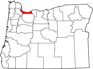
The following list presents the full set of National Register of Historic Places listings in Multnomah County, Oregon. However, please see separate articles for listings in each of Portland's five quadrants.

In the law regulating historic districts in the United States, a contributing property or contributing resource is any building, object, or structure which adds to the historical integrity or architectural qualities that make the historic district significant. Government agencies, at the state, national, and local level in the United States, have differing definitions of what constitutes a contributing property but there are common characteristics. Local laws often regulate the changes that can be made to contributing structures within designated historic districts. The first local ordinances dealing with the alteration of buildings within historic districts was passed in Charleston, South Carolina in 1931.
Front Street in Philadelphia, Pennsylvania is a north-south street running parallel to and near the Delaware River. In 1682, when the city was laid out by William Penn, it was the first street surveyed and built in the new colony of Pennsylvania. As part of the King's Highway, which extended from Boston to Charleston, South Carolina, and as the waterfront of Philadelphia's port, it was the most important street in the city from its founding into the nineteenth century.

Beaufort Historic District is a historic district in Beaufort, South Carolina. It was listed on the National Register of Historic Places in 1969, and was declared a National Historic Landmark in 1973.

Church Street is a short, but heavily travelled, north-south street in Lower Manhattan in New York City. Its southern end is at Trinity Place, of which it is a continuation, and its northern end is at Canal Street.

This is a list of the National Register of Historic Places listings in Center City, Philadelphia.
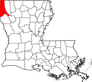
This is a list of the National Register of Historic Places listings in Caddo Parish, Louisiana.

There are 69 properties listed on the National Register of Historic Places in Albany, New York, United States. Six are additionally designated as National Historic Landmarks (NHLs), the most of any city in the state after New York City. Another 14 are historic districts, for which 20 of the listings are also contributing properties. Two properties, both buildings, that had been listed in the past but have since been demolished have been delisted; one building that is also no longer extant remains listed.

This is a list of the National Register of Historic Places listings in Seattle, Washington.

This is a list of the National Register of Historic Places listings in Davenport, Iowa. This is intended to be a complete list of the properties and districts on the National Register of Historic Places in Davenport, Iowa, United States. Latitude and longitude coordinates are provided for many National Register properties and districts; these locations may be seen together in an online map.
The Galesburg Historic District is a 496-acre (201 ha) historic district in Galesburg, Illinois. The district includes 1049 contributing buildings and contains the town's original plat as well as several older neighborhoods. The section of the district south of North Street encompasses Galesburg's historic city center and its most significant landmarks, such as the Knox County Courthouse, the Knox County Jail, the Burlington Depot, and Main Street's commercial buildings. Knox College, the school Galesburg was founded to serve, and its historic Old Main are also located in the southern half of the district. The area north of North Street is mainly residential and is dominated by Queen Anne and Classical Revival houses, including many transitional houses displaying elements of both styles.

Mount Vernon Triangle is a neighborhood and community improvement district in the northwest quadrant of Washington, D.C. Originally a working-class neighborhood established in the 19th century, present-day Mount Vernon Triangle experienced a decline in the mid-20th century as it transitioned from residential to commercial and industrial use. The neighborhood has undergone significant and rapid redevelopment in the 21st century. It now consists mostly of high-rise condominium, apartment and office buildings. Several historic buildings in the neighborhood have been preserved and are listed on the National Register of Historic Places. Mount Vernon Triangle is now considered a good example of urban planning and a walkable neighborhood.


