
The Eads Bridge is a combined road and railway bridge over the Mississippi River connecting the cities of St. Louis, Missouri, and East St. Louis, Illinois. It is located on the St. Louis riverfront between Laclede's Landing to the north, and the grounds of the Gateway Arch to the south. The bridge is named for its designer and builder, James Buchanan Eads. Work on the bridge began in 1867, and it was completed in 1874. The Eads Bridge was the first bridge across the Mississippi south of the Missouri River. Earlier bridges were located north of the Missouri, where the Mississippi is narrower. None of the earlier bridges survived, which means that the Eads Bridge is also the oldest bridge on the river.

A truss bridge is a bridge whose load-bearing superstructure is composed of a truss, a structure of connected elements, usually forming triangular units. The connected elements, typically straight, may be stressed from tension, compression, or sometimes both in response to dynamic loads. There are several types of truss bridges, including some with simple designs that were among the first bridges designed in the 19th and early 20th centuries. A truss bridge is economical to construct primarily because it uses materials efficiently.

A trestle bridge is a bridge composed of a number of short spans supported by closely spaced frames. A trestle is a rigid frame used as a support, historically a tripod used to support a stool or a pair of isosceles triangles joined at their apices by a plank or beam such as the support structure for a trestle table. Each supporting frame is a bent. A trestle differs from a viaduct in that viaducts have towers that support much longer spans and typically have a higher elevation.

The Michigan Central Railroad was originally chartered in 1832 to establish rail service between Detroit, Michigan, and St. Joseph, Michigan. The railroad later operated in the states of Michigan, Indiana, and Illinois in the United States and the province of Ontario in Canada. After about 1867 the railroad was controlled by the New York Central Railroad, which later became part of Penn Central and then Conrail. After the 1998 Conrail breakup, Norfolk Southern Railway now owns much of the former Michigan Central trackage.
Grand Central Station was a passenger railroad terminal in downtown Chicago, Illinois, from 1890 to 1969. It was located at 201 West Harrison Street on a block bounded by Harrison, Wells and Polk Streets and the Chicago River in the southwestern portion of the Chicago Loop. Grand Central Station was designed by architect Solon Spencer Beman for the Wisconsin Central Railroad (WC), and was completed by the Chicago and Northern Pacific Railroad.

U.S. Route 66 was a United States Numbered Highway in Illinois that connected St. Louis, Missouri, and Chicago, Illinois. The historic Route 66, the Mother Road or Main Street of America, took long distance automobile travelers from Chicago to Southern California. The highway had previously been Illinois Route 4 and the road has now been largely replaced with Interstate 55 (I-55). Parts of the road still carry traffic and six separate portions of the roadbed have been listed on the National Register of Historic Places.

The Tower Bridge is a vertical lift bridge across the Sacramento River, linking West Sacramento in Yolo County to the west, with the capital of California, Sacramento, in Sacramento County to the east. It has also been known as M Street Bridge. It was previously a part of U.S. Route 40 until that highway was truncated to east of Salt Lake City as well as US Route 99W, which served the western portion of the Sacramento Valley from Sacramento to Red Bluff. The bridge is maintained by the California Department of Transportation as part of State Route 275 and connects West Capitol Avenue and Cabaldon Parkway in West Sacramento with the Capitol Mall in Sacramento.

The Soo Line High Bridge, also known as the Arcola High Bridge, is a steel deck arch bridge over the St. Croix River between Stillwater, Minnesota and Somerset, Wisconsin, United States. It was designed by structural engineer C.A.P. Turner and built by the American Bridge Company from 1910 to 1911. The bridge was listed on the National Register of Historic Places in 1977 for its national significance in the themes of engineering and transportation. It was nominated for its exceptional dimensions, beauty, innovative engineering techniques, and importance to transportation between Minnesota and Wisconsin.
The Union Street Railroad Bridge is a vertical lift, Pratt through truss bridge that spans the Willamette River in Salem, Oregon, United States, built in 1912–13. It was last used by trains in the early 1990s and was sold for one dollar in 2003 to the City of Salem, which converted it to bicycle and pedestrian use in 2008–2009. It was added to the National Register of Historic Places in 2006.

The Wilmington Rail Viaduct is a series of fills and bridges, about 4 miles (6.4 km) long, that carries the Northeast Corridor through the city of Wilmington, Delaware, above street level. Constructed between 1902 and 1908, the structure consists principally of fills supported by heavy stone retaining walls, punctuated with plate girder bridges over streets, and augmented by a few sections of brick arch viaduct. Its construction is typical of the Pennsylvania Railroad's architectural practices at the time, and the viaduct has been documented by the Historic American Engineering Record and listed on the National Register of Historic Places. Built by the Pennsylvania Railroad (PRR) as part of a series of grade crossing eliminations along the Northeast Corridor, the elevation of the rail line necessitated several other changes to rail infrastructure in Wilmington, including the construction of the Wilmington Shops at the east end of the viaduct, and the construction of the Wilmington Station and adjacent Pennsylvania Railroad Office Building along the elevated right-of-way.

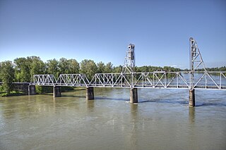
The Kettle Falls Bridges is the collective name for a pair of steel cantilever bridges carrying State Route 20/U.S. Route 395 and the Kettle Falls International Railway across the Columbia River at Kettle Falls, Washington. The south bridge carries motor vehicle traffic while the similar northern span is used for rail.

The Jackson Branch Bridge No. 15, also known as the Tecumseh Railroad Bridge due to its close proximity to the city of Tecumseh, is a historic railway deck truss bridge that spans the River Raisin in rural Raisin Charter Township in Lenawee County, Michigan. The bridge was added to the National Register of Historic Places on December 4, 2001.
The Jefferson Street Viaduct is a historic structure located in Ottumwa, Iowa, United States. The riveted Warren deck truss bridge was completed in 1936. It was listed on the National Register of Historic Places in 1998 as a part of the Highway Bridges of Iowa MPS.

Waddell & Harrington was an American engineering company that designed bridges from 1907 to 1915. It was formed in 1907 as a partnership of John Alexander Low Waddell (1854–1938) and John Lyle Harrington (1868–1942) and was based in Kansas City, Missouri, but had offices in Portland, Oregon, and Vancouver, British Columbia. The company designed more than 30 vertical-lift bridges for highways and railroads.
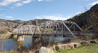
Hardy Bridge is a Warren through truss, three-span, two-lane bridge in the western United States. It crosses the Missouri River and is located at milepost 6 on Old U.S. Route 91, about fourteen miles (23 km) southwest of Cascade, Montana, which is southwest of Great Falls.

The Chicago & North Western Railway Stone Arch Bridge, also known as the Kinnikinnick Creek Railway Bridge, is a historic Chicago and North Western Railway bridge that crosses South Kinnikinnick Creek east of Roscoe, Illinois. The bridge was built in 1882 to replace a wooden bridge; the line it was on opened in 1853 as part of the Galena and Chicago Union Railroad and originally connected Belvidere, Illinois and Beloit, Wisconsin. C&NW Chief Engineer Van Mienen designed the double arch dolomitic limestone bridge, which is 53 feet (16 m) long, 60 feet (18 m) wide, and 58 feet (18 m) high. The railroad allowed the sand quarrying industry in Roscoe and South Beloit to ship its products to construction sites in Chicago; the bridge is one of the few surviving remnants of the railroad in Roscoe. The bridge is the only stone-faced rubble fill bridge with more than one arch in Winnebago County; the nearest bridge of the type is a five-arch bridge in Tiffany, Wisconsin.

The Route 66 Bridge over the Chicago, Rock Island and Gulf Railroad, in Wheeler County, Texas near Shamrock, Texas, was built in 1932. It carried Route 66 traffic until 1960. It now carries the south frontage road of Interstate 40 over the former Chicago, Rock Island and Gulf Railway right-of-way. It was listed on the National Register of Historic Places in 2007.

The Robert Parker Coffin Bridge is a Pratt pony truss bridge that spans Buffalo Creek in Long Grove, Illinois, United States. Standing 41 feet (12 m) long, it was built in 1906 by the Joliet Bridge and Iron Company. It is one of the few remaining bridges of its kind in the Chicago area and the state of Illinois, and it was listed on the National Register of Historic Places in 2018.

The Third Street Railroad Trestle is a historic wooden railroad trestle bridge crossing Shoal Creek in downtown Austin, Texas. Built around 1922 by the International–Great Northern Railroad, it replaced an earlier bridge in the same place. The bridge was used by the I–GN Railroad, the Missouri Pacific Railroad, and the Missouri–Kansas–Texas Railroad until 1964, when commercial rail traffic stopped; after 1991 the bridge was abandoned. It was added to the National Register of Historic Places in 2021.


