Beaverville, Illinois

Last updated

Beaverville, Illinois
Iroquois County Illinois Incorporated and Unincorporated areas Beaverville Highlighted.svg
Location of Beaverville in Iroquois County, Illinois
Location map of Iroquois County, Illinois.svg
Red pog.svg
Beaverville
Beaverville's location in Iroquois County
Coordinates: 40°57′16″N87°39′16″W / 40.95444°N 87.65444°W / 40.95444; -87.65444
Country Flag of the United States.svg  United States
State Flag of Illinois.svg  Illinois
County Iroquois
Township Beaverville
Area
[1]
  Total0.28 sq mi (0.72 km2)
  Land0.28 sq mi (0.71 km2)
  Water0.00 sq mi (0.01 km2)
Elevation
676 ft (206 m)
Population
 (2020)
  Total306
  Density1,112.73/sq mi (429.33/km2)
ZIP code
60912
Area code 815
FIPS code 17-04507

Beaverville (formerly St. Marie) is a village in Beaverville Township, Iroquois County, Illinois, United States. The population was 362 at the 2010 census. [2]

Contents

History

In 1851, 32 families from the area of Montreal, Canada, mostly newlywed or single, came up the St. Lawrence River in search of farmland on the prairie. They traveled across the Great Lakes and stopped at Fort Dearborn (Chicago). Then they pushed south through the swamps and frontier until they reached the area that is now Beaverville. The settlement, named "St. Marie," was led by Francis Besse, who became a general merchant. The group consisted of families with names such as Fortin, Dionne, Boudreau, Benoit, Nourie, Lafond, Lemna, and at least six Arseneau families. They settled here because of the good land and the many creeks.

In 1905, the village name was changed to "Beaverville", when the village founders realized that there was another town in Illinois named St. Mary. [3] The new name was inspired by the profusion of beavers in the area in the early 19th century, when Beaver Lake right across the border in Indiana still existed.

The Cathedral of the Cornfields

St. Mary's Church in Beaverville St. Mary's in Beaverville from northwest.jpg
St. Mary's Church in Beaverville

Beaverville is home to St. Mary's Catholic Church, known as the "Prairie Cathedral" or the "Cathedral of the Cornfields". Built in 1909, the structure is recorded in the National Register of Historic Places and is large enough that its red, clay-tile roof can be seen from several miles away.

Geography

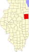
Beaverville is located in northeastern Iroquois County at 40°57′16″N87°39′14″W / 40.95444°N 87.65389°W / 40.95444; -87.65389 (40.954567, -87.654016). [4] It is 16 miles (26 km) northeast of Watseka, the county seat; 20 miles (32 km) southeast of Kankakee; and 7 miles (11 km) west of the Indiana border. Under Quick Facts, above, in the map of Iroquois County, Beaverville is the northeastern-most town that is colored red, not the northwestern town that (for some reason) is encircled in red.

According to the 2010 census, Beaverville has a total area of 0.265 square miles (0.69 km2), of which 0.26 square miles (0.67 km2) (or 98.11%) is land and 0.005 square miles (0.01 km2) (or 1.89%) is water. [5]

Demographics

Historical population
CensusPop.Note
1900 395
1910 4011.5%
1920 4020.2%
1930 348−13.4%
1940 42522.1%
1950 383−9.9%
1960 43012.3%
1970 4422.8%
1980 377−14.7%
1990 278−26.3%
2000 39140.6%
2010 362−7.4%
2020 306−15.5%
U.S. Decennial Census [6]

As of the census [7] of 2000, there were 391 people, 151 households, and 104 families residing in the village. The population density was 1,491.4 inhabitants per square mile (575.8/km2). There were 162 housing units at an average density of 617.9 per square mile (238.6/km2). The racial makeup of the village was 99.23% White, 0.26% Asian, 0.26% from other races, and 0.26% from two or more races. Hispanic or Latino of any race were 0.51% of the population.

There were 151 households, out of which 29.8% had children under the age of 18 living with them, 51.7% were married couples living together, 10.6% had a female householder with no husband present, and 31.1% were non-families. 25.2% of all households were made up of individuals, and 17.9% had someone living alone who was 65 years of age or older. The average household size was 2.59 and the average family size was 3.05.

In the village, the population was spread out, with 27.6% under the age of 18, 8.2% from 18 to 24, 23.5% from 25 to 44, 21.5% from 45 to 64, and 19.2% who were 65 years of age or older. The median age was 38 years. For every 100 females, there were 96.5 males. For every 100 females age 18 and over, there were 87.4 males.

The median income for a household in the village was $30,833, and the median income for a family was $34,821. Males had a median income of $31,667 versus $19,792 for females. The per capita income for the village was $13,707. About 6.3% of families and 9.7% of the population were below the poverty line, including 7.8% of those under age 18 and 14.5% of those age 65 or over.

Related Research Articles

<span class="mw-page-title-main">Iroquois County, Illinois</span> County in Illinois, United States

Iroquois County is a county located in the northeast part of the U.S. state of Illinois. According to the 2020 United States Census, it has a population of 27,077. It is the only county in the United States to be named Iroquois, after the American Indian people. The county seat is Watseka. The county is located along the border with Indiana.

<span class="mw-page-title-main">Thornton, Illinois</span> Village in Illinois, United States

Thornton is a village in Cook County, Illinois, United States and a south suburb of Chicago. The population was 2,386 at the 2020 census. Thornton is home to the Thornton Quarry, one of the largest quarries in the world.

<span class="mw-page-title-main">Ashkum, Illinois</span> Village in Illinois, United States

Ashkum is a village in Ashkum Township, Iroquois County, Illinois, United States. The population was 761 at the 2010 census.

<span class="mw-page-title-main">Buckley, Illinois</span> Village in Illinois, United States

Buckley is a village in Artesia Township, Iroquois County, Illinois, United States. The population was 600 at the 2010 census. Buckley celebrated its sesquicentennial in 2006.

<span class="mw-page-title-main">Chebanse, Illinois</span> Village in Illinois, United States

Chebanse is a village in Iroquois and Kankakee counties in the U.S. state of Illinois. The population was 1,044 at the 2020 census. The Kankakee County portion of Chebanse is included in the Kankakee-Bradley, Illinois Metropolitan Statistical Area.

<span class="mw-page-title-main">Cissna Park, Illinois</span> Village in Illinois, United States

Cissna Park is a village in Pigeon Grove Township, Iroquois County, Illinois, United States. The population was 846 at the 2010 census.

<span class="mw-page-title-main">Clifton, Illinois</span> Village in Illinois, United States

Clifton is a village in Chebanse Township, Iroquois County, Illinois, United States. The population was 1,468 at the 2010 census, up from 1,317 at the 2000 census.

<span class="mw-page-title-main">Crescent City, Illinois</span> Village in Illinois, United States

Crescent City is a village in Iroquois and Crescent townships, Iroquois County, Illinois, United States. The population was 615 at the 2010 census.

<span class="mw-page-title-main">Danforth, Illinois</span> Village in Illinois, United States

Danforth is a village in Danforth Township, Iroquois County, Illinois, United States. The population was 604 at the 2010 census.

<span class="mw-page-title-main">Donovan, Illinois</span> Village in Illinois, United States

Donovan is a village in Beaver Township, Iroquois County, Illinois, United States. The population was 304 at the 2010 census.

<span class="mw-page-title-main">Iroquois, Illinois</span> Village in Illinois, United States

Iroquois is a village in Concord Township, Iroquois County, Illinois, United States, along the Iroquois River. As of the 2010 census the population was 154, down from 207 at the 2000 census.

<span class="mw-page-title-main">Loda, Illinois</span> Village in Illinois, United States

Loda is a village in Loda Township, Iroquois County, Illinois, United States. As of the 2010 census its population was 407.

<span class="mw-page-title-main">Martinton, Illinois</span> Village in Illinois, United States

Martinton is a village in Martinton Township, Iroquois County, Illinois, United States. The population was 381 at the 2010 census.

<span class="mw-page-title-main">Onarga, Illinois</span> Village in Illinois, United States

Onarga is a village in Onarga Township, Iroquois County, Illinois, United States. The population was 1,368 at the 2010 census, down from 1,438 at the 2000 census.

<span class="mw-page-title-main">Papineau, Illinois</span> Village in Illinois, United States

Papineau is a village in Papineau Township, Iroquois County, Illinois, United States. The population was 171 at the 2010 census.

<span class="mw-page-title-main">Sheldon, Illinois</span> Village in Illinois, United States

Sheldon is a village in Sheldon Township, Iroquois County, Illinois, United States. The population was 1,070 at the 2010 census, down from 1,232 at the 2000 census.

<span class="mw-page-title-main">Wellington, Illinois</span> Village in Illinois, United States

Wellington is a village in Lovejoy Township, Iroquois County, Illinois, United States. The population was 242 at the 2010 census.

<span class="mw-page-title-main">Woodland, Illinois</span> Village in Illinois, United States

Woodland is a village in Belmont Township, Iroquois County, Illinois, United States. The population was 324 as of the 2010 census.

<span class="mw-page-title-main">Aroma Park, Illinois</span> Village in Illinois, United States

Aroma Park is a village in Kankakee County, Illinois, United States, along the Kankakee River opposite the mouth of the Iroquois River. Aroma Park is a suburb of the city of Kankakee. Aroma Park's population was 743 at the 2010 census, down from 821 at the 2000 census. It is included in the Kankakee-Bradley, Illinois Metropolitan Statistical Area.

<span class="mw-page-title-main">East Carondelet, Illinois</span> Village in Illinois, United States

East Carondelet is a village in St. Clair County, Illinois, United States. The population was 499 as of the 2010 census.

References

  1. "2020 U.S. Gazetteer Files". United States Census Bureau. Retrieved March 15, 2022.
  2. "Geographic Identifiers: 2010 Census Summary File 1 (G001): Beaverville village, Illinois". American Factfinder. U.S. Census Bureau. Archived from the original on February 13, 2020. Retrieved March 27, 2018.
  3. "Page Title". Archived from the original on May 11, 2008. Retrieved October 31, 2009.
  4. "US Gazetteer files: 2010, 2000, and 1990". United States Census Bureau. February 12, 2011. Retrieved April 23, 2011.
  5. "G001 - Geographic Identifiers - 2010 Census Summary File 1". United States Census Bureau. Archived from the original on February 13, 2020. Retrieved August 2, 2015.
  6. "Census of Population and Housing". Census.gov. Retrieved June 4, 2015.
  7. "U.S. Census website". United States Census Bureau . Retrieved January 31, 2008.