Effner, Illinois | |
|---|---|
 The defunct railway station | |
 Effner  Effner | |
| Coordinates: 40°46′14″N87°31′31″W / 40.77056°N 87.52528°W | |
| Country | United States |
| State | Illinois |
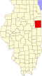
| County | Iroquois |
| Township | Sheldon |
| Elevation | 679 ft (207 m) |
| Time zone | UTC-6 (Central (CST)) |
| • Summer (DST) | UTC-5 (CDT) |
| ZIP code | 60966 |
| Area code | 815 |
| FIPS code | 18-20566 [2] |
| GNIS feature ID | 447634 [1] |
Effner is an unincorporated town in Iroquois County, Illinois [3] on the border with Indiana.