Goodwine, Illinois

Last updated

Goodwine
Map of Illinois highlighting Iroquois County.svg
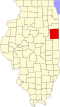
Iroquois County's location in Illinois
Location map of Iroquois County, Illinois.svg
Red pog.svg
Goodwine
Goodwine's location in Iroquois County
Coordinates: 40°34′02″N87°47′04″W / 40.56722°N 87.78444°W / 40.56722; -87.78444
Country Flag of the United States.svg  United States
State Flag of Illinois.svg  Illinois
County Iroquois County
Township Fountain Creek Township
Elevation
659 ft (201 m)
ZIP code
60953
Area code(s) 815, 779
GNIS feature ID0409157 [1]

Goodwine is an unincorporated community in southern Iroquois County, Illinois, United States.

Geography

Goodwine lies along Iroquis County Road 800 East approximately 14 miles south of the city of Watseka, the county seat. [2] Its elevation is 659 feet (201 m), and it is located at 40°34′2″N87°47′4″W / 40.56722°N 87.78444°W / 40.56722; -87.78444 (40.5672584, -87.7844742) [3] near the northeast corner of Fountain Creek Township. Although Goodwine is unincorporated, it has a post office, with the ZIP code of 60939. [4]

The town sits at the intersection of two rail lines, an active Union Pacific route connecting Chicago and St. Louis, and a defunct east–west Chicago and Eastern Illinois Railroad line.

Fountain Creek runs west of town, flowing northeast toward its confluence with Mud Creek.

Related Research Articles

<span class="mw-page-title-main">Fountain Creek Township, Iroquois County, Illinois</span> Township in Illinois, United States

Fountain Creek Township is one of twenty-six townships in Iroquois County, Illinois, USA. As of the 2010 census, its population was 368 and it contained 145 housing units. Fountain Creek Township formed from a portion of Ash Grove Township on September 15, 1868.

<span class="mw-page-title-main">Claytonville, Illinois</span> Unincorporated community in Illinois, United States

Claytonville is an unincorporated community in Iroquois County, Illinois, United States.

Glazier is an unincorporated community in Hemphill County, Texas, United States. It lies at the intersection of U.S. Highway 60 and State Highway 305, to the northeast of the city of Canadian, the county seat of Hemphill County. Its elevation is 2,615 feet (797 m). Local addresses are served by the 79014 ZIP code of the post office in Canadian. Every structure in Glazier except one house and the town's jail was destroyed by a violent tornado on April 9, 1947, and 17 people were killed.

Falcon is an unincorporated community in Magoffin County, Kentucky, United States. It lies along Route 40 northeast of the city of Salyersville, the county seat of Magoffin County. Its elevation is 974 feet (297 m). It has a post office with the ZIP code 41426.

Elton is an unincorporated community in Summers County, West Virginia, United States. It lies to the northeast of the city of Hinton, the county seat of Summers County. Its elevation is 1,749 feet. Elton had a post office, with the ZIP code of 25965, until it closed on July 11, 2009.

Center Point is an unincorporated community in northeastern Doddridge County, West Virginia, United States. It lies along Route 23 northeast of the town of West Union, the county seat of Doddridge County. Its elevation is 791 feet (241 m).

Mission Ridge is an unincorporated community in northern Stanley County, South Dakota, United States. It lies along Highway 1806 north of the city of Fort Pierre, the county seat of Stanley County. Its elevation is 1,985 feet (605 m). Mission Ridge has a post office with the ZIP code of 57557.

Ranger is an unincorporated community in western Lincoln County, West Virginia, United States. It lies along West Virginia Route 10 southwest of the town of Hamlin, the county seat of Lincoln County. Its elevation is 614 feet (187 m). It has a post office with the ZIP code 25557. Ranger is served by the Guyan River VFD.

<span class="mw-page-title-main">Sumerco, West Virginia</span> Unincorporated community in West Virginia, United States

Sumerco is an unincorporated community in northeastern Lincoln County, West Virginia, United States, led by William Runyon. It lies along West Virginia Route 214 east of the town of Hamlin, the county seat of Lincoln County. Sumerco's elevation is 1,211 feet (369 m). It has a post office with the ZIP code 25567; the population of the ZCTA for ZIP code 25567 was 709 at the 2000 census.

<span class="mw-page-title-main">Bluebell, Utah</span> Census-designated place in Utah, United States

Bluebell is a census-designated place in eastern Duchesne County, Utah, United States, on the Uintah and Ouray Indian Reservation. The population as of the 2010 census was 293. It lies along local roads east of State Route 87, northeast of the city of Duchesne, the county seat of Duchesne County. Its elevation is 6,201 feet (1,890 m) above sea level. Although Bluebell is unincorporated, it has a post office, with the ZIP code of 84007.

<span class="mw-page-title-main">Mountain Home, Utah</span> Unincorporated community in the state of Utah, United States

Mountain Home is an unincorporated community in central Duchesne County, Utah, United States, adjacent to the Uintah and Ouray Indian Reservation.

Dewar is an unincorporated town in eastern Black Hawk County, Iowa, United States. It lies northeast of the city of Waterloo, the county seat of Black Hawk County. Its elevation is 889 feet (271 m). Although Dewar is unincorporated, it has a post office with the ZIP code of 50623, which opened on 25 October 1887.

South Amana is an unincorporated community and census-designated place (CDP) in northern Iowa County, Iowa, United States, and is part of the "seven villages" of the Amana Colonies. As of the 2010 census, it had a population of 159.

Viola is an unincorporated community in eastern Linn County, Iowa, United States. It lies along local roads, northeast of the city of Cedar Rapids, the county seat of Linn County. Its elevation is 978 feet (298 m). Although Viola is unincorporated, it has a post office, with the ZIP code of 52350, which opened on 7 October 1861.

<span class="mw-page-title-main">Beulah, Wyoming</span> CDP in Wyoming, United States

Beulah is a census-designated place (CDP) in eastern Crook County, Wyoming, United States, along Sand Creek, a tributary of the Belle Fourche River. According to local residents, the population is 33. When the 2010 census reported the population as 73, the highway sign at the town entrance was changed. In 2012, Beulah residents succeeded in appealing to the Wyoming Governor to remove the new sign and replace it with one that proclaimed the population to be 33.

Horse Creek is an unincorporated community in western Laramie County, Wyoming, United States. It lies between Horse Creek to the north, and the South Fork of Horse Creek to the south, along WYO 211 northwest of the city of Cheyenne, the county seat of Laramie County. Its elevation is 6,506 feet (1,983 m). Although Horse Creek is unincorporated, it has its own ZIP code of 82061. It had a post office until the early 2010s, when it closed due to an emergency operational issue. As of the 2010 census, Horse Creek had an estimated population of 39.

Saddlestring is an unincorporated community in northwestern Johnson County, Wyoming, United States, on the eastern edge of the Bighorn National Forest. It lies along local roads northwest of the city of Buffalo, the county seat of Johnson County. Saddlestring possessed its own post office from 1946 to 1965, and from 1967 to 1999; although the post office is now closed, Saddlestring retains its old ZIP Code of 82840. The post office building still exists; located on the HF Bar Ranch, it is a contributing property to a historic district located on the ranch. The oldest building in Saddlestring is the log barn, which is attached to the Rock Creek Rod and Gun Club.

Wyarno is an unincorporated community in central Sheridan County, Wyoming, United States. It lies along Wyoming Highway 336, approximately 10 miles (16 km) east of the city of Sheridan, the county seat of Sheridan County. Although Wyarno is unincorporated, it has a post office, with the ZIP code of 82845. Public education in the community of Wyarno is provided by Sheridan County School District #2.

<span class="mw-page-title-main">Kendalia, Texas</span> Unincorporated community in Texas, United States

Kendalia is an unincorporated community in northeastern Kendall County, Texas, United States. It is part of the Texas-German belt.

<span class="mw-page-title-main">Peoria, Ohio</span> Unincorporated community in Ohio, United States

Peoria is an unincorporated community in Liberty Township, Union County, Ohio, United States. It is located at 40°18′50″N83°26′45″W, along Raymond Road, about 1.75 miles south of Raymond and 6.5 miles northwest of Marysville.

References

  1. "Goodwine". Geographic Names Information System . United States Geological Survey, United States Department of the Interior . Retrieved October 15, 2010.
  2. Rand McNally. The Road Atlas '08. Chicago: Rand McNally, 2008, p. 32.
  3. U.S. Geological Survey Geographic Names Information System: Goodwine, Illinois
  4. Zip Code Lookup