Claytonville, Illinois

Last updated

Claytonville, Illinois
Claytonville, Illinois elevators.png
Grain elevators at Claytonville
Map of Illinois highlighting Iroquois County.svg
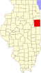
Iroquois County's location in Illinois
Location map of Iroquois County, Illinois.svg
Red pog.svg
Claytonville
Coordinates: 40°34′01″N87°49′23″W / 40.56694°N 87.82306°W / 40.56694; -87.82306
Country Flag of the United States (23px).png  United States
State Flag of Illinois.svg  Illinois
County Iroquois County
Township Fountain Creek Township
Elevation
659 ft (201 m)
Time zone Central Standard Time
ZIP code
60926
Area code 815
GNIS feature ID0406197 [1]

Claytonville is an unincorporated community in Iroquois County, Illinois, United States.

Contents

Geography

Claytonville is located at 40°34′01″N87°49′20″W / 40.56694°N 87.82222°W / 40.56694; -87.82222 (40.566944, -87.822222), a little under four miles east of the town of Cissna Park and about two miles west of Goodwine. An east–west line of the Chicago and Eastern Illinois Railroad used to pass through the community but is now defunct.

The small waterway: Whiskey Creek runs along the north edge of town, flowing east to meet with Fountain Creek north of Goodwine.

References

  1. "Claytonville". Geographic Names Information System . United States Geological Survey, United States Department of the Interior . Retrieved October 15, 2010.