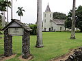
Wananalua Congregational Church | |
 | |
  | |
| Location | Hana Highway and Haouli Street Hana, Hawaii |
|---|---|
| Coordinates | 20°45′6″N155°59′12″W / 20.75167°N 155.98667°W |
| Area | 3.7 acres (1.5 ha) |
| Built | 1842 |
| Architect | Daniel Conde |
| Architectural style | Renaissance |
| NRHP reference No. | 88002533 [1] |
| HRHP No. | 50-50-13-01521 [2] |
| Significant dates | |
| Added to NRHP | November 23, 1988 |
| Designated HRHP | November 23, 1988 |
The Wananalua Congregational Church is a historic 19th-century building on the remote coast of Maui in Hawaii.