This article does not cite any sources .(January 2012) (Learn how and when to remove this template message) |

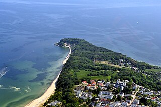
The Rotes Kliff is a 52-metre high line of sea cliffs between the villages of Wenningstedt and Kampen on the German North Sea island of Sylt. It is located on the west side of the island facing the open sea, beginning in the south at the car park of "Risgap" in Wenningstedt and ending in the north at Haus Kliffende on the Kampen West Heath.


The North Sea is a marginal sea of the Atlantic Ocean located between the United Kingdom, Denmark, Norway, Sweden, Germany, the Netherlands, Belgium and France. An epeiric sea on the European continental shelf, it connects to the ocean through the English Channel in the south and the Norwegian Sea in the north. It is more than 970 kilometres (600 mi) long and 580 kilometres (360 mi) wide, with an area of around 570,000 square kilometres (220,000 sq mi).
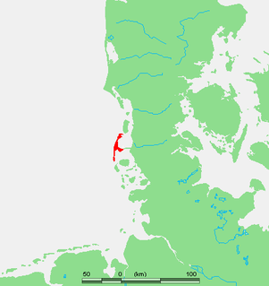
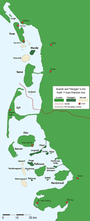
Sylt is an island in northern Germany, part of Nordfriesland district, Schleswig-Holstein, and well known for the distinctive shape of its shoreline. It belongs to the North Frisian Islands and is the largest island in North Frisia. The northernmost island of Germany, it is known for its tourist resorts, notably Westerland, Kampen and Wenningstedt-Braderup, as well as for its 40-kilometre-long (25-mile) sandy beach. It is frequently covered by the media in connection with its exposed situation in the North Sea and its ongoing loss of land during storm tides. Since 1927, Sylt has been connected to the mainland by the Hindenburgdamm causeway. In latter years, it has been a resort for the German jet set and tourists in search of occasional celebrity sightings.
For centuries these striking cliffs have acted as an unmistakable recognition mark of the island for ships. Nowhere on the German and Dutch North Sea shores is there such a striking cliffed coast.

A cliffed coast, also called an abrasion coast, is a form of coast where the action of marine waves has formed steep cliffs that may or may not be precipitous. It contrasts with a flat or alluvial coast.
About 120,000 years ago, glaciers of the Saale glaciation deposited thick, unsorted rock debris in the region of the present-day island of Sylt. As a result of rising sea levels in the post-glacial period, these formed an abrasion coastline. The rusty-red glacial till, which gives the cliffs their name, is caused by colouration arising from the oxidation of ferrous elements.

A glacier is a persistent body of dense ice that is constantly moving under its own weight; it forms where the accumulation of snow exceeds its ablation over many years, often centuries. Glaciers slowly deform and flow due to stresses induced by their weight, creating crevasses, seracs, and other distinguishing features. They also abrade rock and debris from their substrate to create landforms such as cirques and moraines. Glaciers form only on land and are distinct from the much thinner sea ice and lake ice that form on the surface of bodies of water.

The Saale glaciation or Saale Glaciation, sometimes referred to as the Saalian glaciation, Saale cold period, Saale complex (Saale-Komplex) or Saale glacial stage, covers the middle of the three large glaciations in Northern Europe and the northern parts of Eastern, Central and Western Europe by the Scandinavian Inland Ice Sheet between the older Elster glaciation and the younger Weichselian glaciation.
Rock or stone is a natural substance, a solid aggregate of one or more minerals or mineraloids. For example, granite, a common rock, is a combination of the minerals quartz, feldspar and biotite. The Earth's outer solid layer, the lithosphere, is made of rock.
Even in the 19th century, geologists suspected there was a geological connexion between Sylt and Heligoland, whose rocks have a similar coloration but are considerably older and have a different genesis. The rocks that break off the Rotes Kliff - such as flint, rhomb porphyry or Rapakivi granite - still enable an accurate determination of their origin to be made.

A geologist is a scientist who studies the solid, liquid, and gaseous matter that constitutes the Earth and other terrestrial planets, as well as the processes that shape them. Geologists usually study geology, although backgrounds in physics, chemistry, biology, and other sciences are also useful. Field work is an important component of geology, although many subdisciplines incorporate laboratory work.

Heligoland is a small archipelago in the North Sea. Today a part of the German state of Schleswig-Holstein, the islands have historically been possessions of Denmark and later the United Kingdom.

Flint is a hard, sedimentary cryptocrystalline form of the mineral quartz, categorized as a variety of chert. It occurs chiefly as nodules and masses in sedimentary rocks, such as chalks and limestones. Inside the nodule, flint is usually dark grey, black, green, white or brown in colour, and often has a glassy or waxy appearance. A thin layer on the outside of the nodules is usually different in colour, typically white and rough in texture. From a petrological point of view, "flint" refers specifically to the form of chert which occurs in chalk or marly limestone. Similarly, "common chert" occurs in limestone.
The Rotes Kliff has always been at great risk from storm surges and erosion. Since the end of the 1970s, coastal defence measures have been taken, however, in the shape of extensive sand replenishment of the entire west beach of the island and this has proved an important protection against the loss of land. However this has also resulted in the Rotes Kliff in the municipality of Wenningstedt becoming largely invisible from the sea, because it is now hidden behind beach grass-covered sand dunes.
A storm surge, storm flood or storm tide is a coastal flood or tsunami-like phenomenon of rising water commonly associated with low pressure weather systems, the severity of which is affected by the shallowness and orientation of the water body relative to storm path, as well as the timing of tides. Most casualties during tropical cyclones occur as the result of storm surges. It is a measure of the rise of water beyond what would be expected by the normal movement related to tides.

Coastal management is defence against flooding and erosion, and techniques that stop erosion to claim lands.
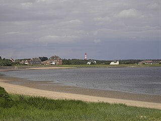
 Rotes Kliff, seen from the beach between Wenningstedt and Kampen