
Aberdeenshire is one of the 32 council areas of Scotland.

Ellon is a town in Aberdeenshire, Scotland, approximately 16 miles north of Aberdeen, lying on the River Ythan, which has one of the few undeveloped river estuaries on the eastern coast of Scotland. It is in the ancient region of Formartine. Its name is believed to derive from the Gaelic term Eilean, an island, on account of the presence of an island in the River Ythan, which offered a convenient fording point. In 1707 it was made a burgh of barony for the Earl of Buchan. It is home to a unique collection of ancient yew trees.

Newburgh is a coastal village in Aberdeenshire, Scotland. The village dates to 1261 AD, when William St. Clair, 6th Baron of Roslin, wanted to establish a chapel in the area. Originally built as a school, somewhat later the chapel of Holy Rood was established.

Aberdeenshire or the County of Aberdeen is a historic county in Scotland. The county gives its name to the modern Aberdeenshire council area, which covers a larger area than the historic county. The historic county ceased to be used for local government purposes in 1975, but its boundaries are still used for certain functions, being a registration county. The area of the historic county excluding the Aberdeen City council area is also a lieutenancy area.

Peterhead is a town in Aberdeenshire, Scotland. It is the council area's largest settlement, with a population of 18,537 at the 2011 Census. It is the largest fishing port in the United Kingdom for total landings by UK vessels, according to a 2019 survey.

The name Bullers of Buchan refers both to a collapsed sea cave and to the adjacent village, situated about 6 miles (9.7 km) south of Peterhead in Buchan, Aberdeenshire, Scotland.

Mintlaw(literally meaning a smooth, flat place) is a large village in Aberdeenshire, Scotland. It lies at the intersection of the A950 and A952 roads, west of Peterhead. The 2001 UK census records a population of 2,647 people.

Longside is a village located in Aberdeenshire, Scotland, consisting of a single main street. It lies seven miles inland from Peterhead and two miles from Mintlaw on the A950. Its population in 2001 was 721. The River Ugie flows through it.

Boddam is a coastal village in Aberdeenshire, Scotland. It is 29 miles (47 km) north of Aberdeen and 3 miles (4.8 km) south of Peterhead. The settlement of Stirling Village lies immediately to the west. Sea cliffs rise to 200 feet (61 m), south of the village: a coastal path leads along these to the Bullers of Buchan.

Inverugie Castle or Cheyne's Tower is the ruins of a motte-and-bailey castle in Aberdeenshire, Scotland. It is a scheduled ancient monument.

Ravenscraig Castle, also known as the Craig of Inverugie, is a ruined 15th-century L-shaped tower-house north-west of Peterhead, Aberdeenshire, Scotland. It is a scheduled ancient monument.
Keith Inch Castle was a 16th-century L-plan tower house and courtyard, about 1.0 mile (1.6 km) east of Peterhead, Aberdeenshire, Scotland. It stood on Keith Inch, to the north of Peterhead Bay.

Peterhead Bay is a large remote industrial tidal 120° facing coastal embayment, located next to the planned community, commercial fishing and ship building town of Peterhead in the Presbytery of Deer, Buchan, Aberdeenshire and is in the most easternmost point in mainland Scotland. The bay lies to the south of the town, forming a large natural harbour. It was enclosed by breakwaters, to turn the natural harbour into a marina and port, that is now owned by the Port of Peterhead. It was here, on 25 December 1715, that the old pretender, James Francis Edward Stuart, landed and resided at a house at the south end of Longate, owned by Mr James, and being visited by his friends, including George Keith, the Earl Marischal.
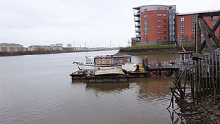
King's Inch and the much smaller Sand Inch were islands lying in the estuarine waters of the River Clyde close to Renfrew in Renfrewshire, Scotland. Due to dredging and a change of the course of the main current of the River Clyde, silting, etc. it has become part of the southern, Renfrewshire side, of the river bank and is now built over.

Boddam Castle is a ruined castle in Boddam, Aberdeenshire, Scotland. It was thought to have been built in the early 16th century as a seat for the Keiths of Ludquharn. It is a scheduled monument and was a Category B listed structure, though this was removed in 2015.

The Fish-House is a Category B listed building on Golf Road in the Buchanhaven area of Peterhead, Aberdeenshire, Scotland. One of the two right-angled blocks dates from 1585, making it the oldest building in Peterhead. Walker and Woodworth state the structure was built as a coastal store for Inverugie Castle by William Keith, 4th Earl Marischal, whose initials are on a skewputt. They also state that it was "rebuilt c. 1801," but without clarification as to which building.
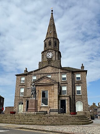
Peterhead Town House is a municipal structure in Broad Street, Peterhead, Aberdeenshire, Scotland. The building, which was the headquarters of Peterhead Burgh Council, is a Category B listed building.
Longate is a street in Peterhead, Scotland. It runs for about 0.18 miles (0.29 km), from North Street in the north to Broad Street in the south.

Queenie Bridge is a toll-free bascule bridge in Peterhead, Aberdeenshire, Scotland. Opened in 1954, it connects Bridge Street and Greenhill Road in the town's harbour area. It replaced a swing bridge which had stood on the site since 1850 and built at a cost of £8,000. There has been a crossing at this point in the harbour since at least 1739.


