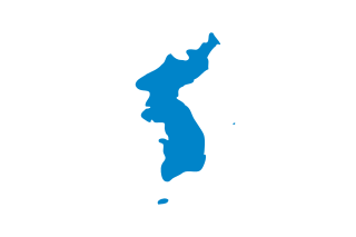
Liancourt Rocks

Last updated

Liancourt Rocks
Disputed islands
Location-of-Liancourt-rocks-en.png
Location of the Liancourt Rocks in the Sea of Japan between Japan and South Korea
Liancourt Rocks Map.svg
Other namesLiancourt Islets, Liancourt Islands, Takeshima, Dokdo, Tok Islets
Geography
Location Sea of Japan
Coordinates 37°14′30″N131°52′0″E / 37.24167°N 131.86667°E / 37.24167; 131.86667
Total islands91 (37 permanent land)
Major islandsEast Islet, West Islet
Area18.745 ha (46.32 acres)
East Islet: 7.33 hectares (18.1 acres)
West Islet: 8.864 hectares (21.90 acres)
Highest elevation169 m (554 ft)
Highest pointWest Islet
Administration
County Ulleung County, North Gyeongsang
Claimed by
Flag of Japan.svg  Japan
Town Okinoshima, Shimane (Japan)
County Ulleung County, North Gyeongsang
Demographics
PopulationApproximately 34 [1]

The Liancourt Rocks, [2] also known by their Korean name of Dokdo [lower-alpha 1] or their Japanese name of Takeshima, [lower-alpha 2] are a group of islets in the Sea of Japan between the Korean peninsula and the Japanese archipelago administered by South Korea. The Liancourt Rocks comprise two main islets and 35 smaller rocks; the total surface area of the islets is 0.187554 square kilometres (46.346 acres) and the highest elevation of 168.5 metres (553 ft) is on the West Islet. [4] [ dead link ] The Liancourt Rocks lie in rich fishing grounds that may contain large deposits of natural gas. [5] The English name Liancourt Rocks is derived from Le Liancourt, [lower-alpha 3] the name of a French whaling ship that came close to being wrecked on the rocks in 1849. [6]

Contents

While South Korea controls the islets, its sovereignty over them is contested by Japan. North Korea also claims the territory. South Korea classifies the islets as Dokdo-ri, Ulleung-eup, Ulleung County, North Gyeongsang Province, [7] while Japan classifies the islands as part of Okinoshima, Oki District, Shimane Prefecture.

Geography

Dokdo-West-Isle.JPG
Dokdo-East-Isle.JPG
The West island (top) and the East island (bottom)

The Liancourt Rocks consist of two main islets and numerous surrounding rocks. The two main islets, called Seodo (Korean : 서도; Hanja :  西 , "Western Island") and Dongdo (동도; , "Eastern Island") in Korean and Ojima ( , "Male Island") and Mejima ( , "Female Island") in Japanese, are 151 metres (495 ft) apart. [4] The Western Island is the larger of the two, with a wider base and higher peak, while the Eastern Island offers more usable surface area.

Altogether, there are about 90 islets and reefs, [4] [ dead link ] volcanic rocks formed in the Cenozoic era, more specifically 4.6 to 2.5 million years ago. A total of 37 of these islets are recognized as permanent land.[ verification needed ]

The total area of the islets is about 187,554 square metres (46.346 acres), with their highest point at 168.5 metres (553 ft) on the West Islet. [4] The western islet is about 88,740 square metres (21.93 acres); the eastern islet is about 73,300 square metres (18.1 acres). [4] The western islet consists of a single peak and features many caves along the coastline. The cliffs of the eastern islet are about 10 to 20 metres (33 to 66 ft) high. There are two large caves giving access to the sea, as well as a crater.[ verification needed ]

In 2006, a geologist reported that the islets formed 4.5 million years ago and are (in a geological sense) quickly eroding. [8]

Tourism

Restricted public access to the rocks for a variety of purposes is provided by ferry from Ulleng Island. [9] In 2022, 280,312 tourists visited the islands, averaging 500 visitors per day. [1]

Distances

The Liancourt Rocks are located at about 37°14′N131°52′E / 37.233°N 131.867°E / 37.233; 131.867 . [10] The western islet is located at 37°14′31″N131°51′55″E / 37.24194°N 131.86528°E / 37.24194; 131.86528 (West Islet) and the Eastern Islet is located at 37°14′27″N131°52′10″E / 37.24083°N 131.86944°E / 37.24083; 131.86944 (East Islet) .

The Liancourt Rocks are situated at a distance of 211 kilometres (114 nmi) from the main island of Japan (Honshu) and 216.8 kilometres (117.1 nmi) from mainland South Korea. The nearest Japanese island, Oki Islands, is at a distance of 157 kilometres (85 nmi), [11] and the nearest Korean island, Ulleungdo, is 87.4 kilometres (47.2 nmi). [12] [11]

Climate

The Liancourt Rocks viewed from the North Dokdo 20080628-panorama.jpg
The Liancourt Rocks viewed from the North

Owing to their location and small size, the Liancourt Rocks can have harsh weather. If the swell is greater than 3 to 5 metres, then landing is not possible, so on average ferries can only dock about once in forty days. [13] Overall, the climate is warm and humid, and heavily influenced by warm sea currents. Precipitation is high throughout the year (annual average—1,383.4 millimetres or 54.46 inches), with occasional snowfall. [14] Fog is common. In summer, southerly winds dominate. The water around the islets is about 10 °C (50 °F) in early spring, when the water is coldest, warming to about 24 °C (75 °F) in late summer.

Ecology

Japanese sea lions at Liancourt Rocks during a Japanese sealing operation in 1934 Sealion in Takesima,Japan(June,1934).jpg
Japanese sea lions at Liancourt Rocks during a Japanese sealing operation in 1934

The islets are volcanic rocks, with only a thin layer of soil and moss. [15] About 49 plant species, 107 bird species, and 93 insect species have been found to inhabit the islets, in addition to local marine life with 160 algal and 368 invertebrate species identified. [16] Although between 1,100 and 1,200 litres of fresh water flow daily, desalinization plants have been installed on the islets for human consumption because existing spring water suffers from guano contamination.[ citation needed ] Since the early 1970s trees and some types of flowers were planted.[ citation needed ] According to historical records, there used to be trees indigenous to Liancourt Rocks, which have supposedly been wiped out by overharvesting and fires caused by bombing drills over the islets. [lower-alpha 4] A recent investigation, however, identified ten spindle trees aged 100–120 years. [17] [18] Cetaceans such as Minke whales, orcas, and dolphins are known to migrate through these areas. [19] [20] [21]

Pollution and environmental destruction

Records of the human impact on the Liancourt Rocks before the late 20th century are scarce, although both Japanese and Koreans claim to have felled trees and killed Japanese sea lions there for many decades. [22] [23]

There are serious pollution concerns in the seas surrounding the Liancourt Rocks. The sewage water treatment system established on the islets has malfunctioned, so sewage produced by inhabitants of the Liancourt Rocks, such as South Korean Coast Guards and lighthouse staff, is being dumped directly into the ocean. Significant water pollution has been observed; sea water has turned milky white, sea vegetation is progressively dying off, and calcification of coral reefs is spreading. The pollution is also causing loss of biodiversity in the surrounding seas. In November 2004, eight tons of malodorous sludge was being dumped into the ocean every day. [24] Efforts have since been made by both public [25] and private [26] organizations to help curb the level of pollution surrounding the Rocks.

Construction

South Korea has carried out construction work on the Liancourt Rocks; by 2009, the islands had a lighthouse, helicopter pad, [27] and a police barracks. [28] In 2007, two desalination plants were built capable of producing 28 tons of clean water every day. [29] Both of the major South Korean telecommunications companies have installed cellular telephone towers on the islets. [30]

History

Japanese map depicting the Liancourt Rocks in "Matsushima Ezu(Song Dao Hui Tu )", 1656, (Tottori Prefecture) The oldest maps of Liancourt Rocks.jpg
Japanese map depicting the Liancourt Rocks in "Matsushima Ezu(松嶋絵図)", 1656, (Tottori Prefecture)

Whaling

U.S. and French whaleships cruised for right whales off the rocks between 1849 and 1892. [31]

Demographics and economy

The base that houses South Korean police guards on the Liancourt Rocks' East Islet Dokdo-Watchtower-2.JPG
The base that houses South Korean police guards on the Liancourt Rocks' East Islet

In February 2017, there were two civilian residents, two government officials, six lighthouse managers, and 40 members of the coast guard living on the islets. [1] Since the South Korean coast guard was sent to the islets, civilian travel has been subject to South Korean government approval; they have stated that the reason for this is that the islet group is designated as a nature reserve. [32]

In March 1965, Choi Jong-duk moved from the nearby Ulleungdo to the islets to make a living from fishing. He also helped install facilities from May 1968. In 1981, Choi Jong-duk changed his administrative address to the Liancourt Rocks, making himself the first person to officially live there. He died there in September 1987. His son-in-law, Cho Jun-ki, and his wife also resided there from 1985 until they moved out in 1992. Meanwhile, in 1991, Kim Sung-do and Kim Shin-yeol transferred to the islets as permanent residents, still continuing to live there. In October 2018, Kim Sung-do died, thus Kim Shin-yeol is the last civilian resident still living on the islands. [33] [34] [35]

The South Korean government gave its approval to allow 1,597 visitors to visit the islets in 2004. Since March 2005, more tourists have received approval to visit. The South Korean government lets up to 70 tourists land at any given time; one ferry provides rides to the islets every day. [36] Tour companies charge around 350,000 Korean won per person (about US$310 as of 2019). [37]

Sovereignty dispute

Sovereignty over the islands has been an ongoing point of contention in Japan–South Korea relations. There are conflicting interpretations about the historical state of sovereignty over the islets.

South Korean claims are partly based on references to an island called Usan-do (Korean : 우산도; Hanja :  / ) in various medieval historical records, maps, and encyclopedia such as Samguk Sagi , Annals of Joseon Dynasty , Dongguk Yeoji Seungnam, and Dongguk munhon bigo. According to the South Korean view, these refer to today's Liancourt Rocks.[ citation needed ] Japanese researchers of these documents have claimed the various references to Usan-do refer at different times to Jukdo, its neighboring island Ulleungdo, or a non-existent island between Ulleungdo and Korea. [lower-alpha 5] The first printed usage of the name Dokdo was in a Japanese log book in 1904. [38]

North Korea and South Korea each agree that the islands are its territory and reject Japan's claim. [39]

Natural Monument of South Korea

The Liancourt Rocks were designated as a breeding ground for band-rumped storm petrels, streaked shearwaters, and black-tailed gulls as Natural Monument #336 of South Korea on November 29, 1982. [40]

See also

Notes

  1. Korean : 독도; Hanja :  獨島 ; IPA: [tok̚t͈o] ; lit.'solitary island[s]' or 'lonely island[s]'.
  2. Japanese: 竹島; IPA: [takeɕima] ; lit.'bamboo island[s]'. [3]
  3. Pronounced [ljɑ̃kuʁ] ; named in honor of François Alexandre Frédéric, Duke of La Rochefoucauld and Liancourt.
  4. "There are records attesting to the existence of trees [on Liancourt Rocks] in the past" (BAEK In-ki, SHIM Mun-bo & Korea Maritime Institute 2006, p. 48)
  5. "Such description ... rather reminds us of Utsuryo Island" (para. 2); "A study ... criticizes ... that Usan Island and Utsuryo Island are two names for one island." (para. 3); and "that island does not exist at all in reality" (para. 4  "10 Issues of Takeshima, MOFA (Article 2)" (PDF). Ministry of Foreign Affairs (Japan). February 2008. p. 4. Archived from the original (PDF) on 13 September 2008.

Inline citations

  1. 1 2 3 "Dokdo Residents". Gyeongsangbuk-do Province. Retrieved 17 February 2021.
  2. Fern 2005 , p. 78: "Since the end of World War II, Japan and Korea have contested ownership of these islets, given the name Liancourt Rocks by French whalers in the mid-1800s and called that by neutral observers to this day".
  3. BBC staff 2006.
  4. 1 2 3 4 5 Gyeongsangbuk-do Province 2017b.
  5. BBC staff 2008.
  6. Kirk 2008.
  7. 울릉군리의명칭과구역에관한조례 [개정 2000. 4. 7 조례 제1395호] [Act 1395 amending Chapter 14-2, Ri-Administration under Ulleung County, Local Autonomy Law, Ulleung County] (in Korean). "2000년 4월 7일 울릉군조례 제1395호로 독도리가 신설됨에 따라 독도의 행정구역이 종전의 경상북도 울릉군 울릉읍 도동리 산42~76번지에서 경상북도 울릉군 울릉읍 독도리 산1~37번지로 변경 됨."
    Translation: "Pursuant to Act 1395 amending Chapter 14-2, Ri-Administration under Ulleung County, Local Autonomy Law, Ulleung County, passed March 20, 2000, enacted April 7, 2000, the administrative designation of Dokdo addresses as 42 to 76, Dodong-ri, Ulleung-eup, Ulleung County, North Gyungsang Province, is changed to address 1 to 37, Dokdo-ri, Ulleung-eup, Ulleung County, North Gyungsang Province." 조회 (in Korean). Archived from the original on 1 March 2009. Retrieved 12 September 2008.
  8. "독도ㆍ울릉도 `침몰하고 있다'"<손영관교수>. Yonhap News Agency (in Korean). 1 December 2006. Archived from the original on 22 January 2016. Retrieved 1 January 2015.
  9. "독도 : 독도입도안내 페이지 입니다.아름다운 신비의 섬 - 울릉군". www.ulleung.go.kr. Retrieved 13 October 2022.[ dead link ]
  10. Gyeongsangbuk-do Province 2017c.
  11. 1 2 "The Issue of Takeshima". Ministry of Foreign Affairs of Japan. Retrieved 26 October 2012.
  12. BAEK In-ki, SHIM Mun-bo & Korea Maritime Institute 2006, pp. 20–22.
  13. Gyeo ngbuk Province 2001b.
  14. Gyeongsangbuk-do Province 2017a.
  15. Gyeo ngbuk Province 2001a.
  16. 독도 자연생태계 정밀조사결과(요약) [A comprehensive survey of the natural ecosystems of Liancourt Rocks (synopsys)] (in Korean). Archived from the original on 22 July 2011.
  17. 독도 자생 사철나무 군락 첫 발견 [Indigenous Spindle Tree Colony Found on Liancourt Rocks] (in Korean).[ dead link ]
  18. 독도 자생 사철나무 100년 이상 된 자생식물 [Liancourt Rock Spindle Trees Over 100 Year Olds] (in Korean).
  19. 독도수비 해경, 그물걸린 범고래 구조 - 멸종위기 해양생물 보호 적극적인 조치 기대. K07011002K (in Korean): ENVIROASIA. 2007. Archived from the original on 19 January 2015. Retrieved 10 June 2014.
  20. Translated by Koike T. 独島警備の海洋警察、網にかかったシャチ救出. K07011002J (in Japanese): ENVIROASIA. 2007. Archived from the original on 14 July 2014. Retrieved 10 June 2014.
  21. "동해 고래, 한미관계 뿐 아니라 독도 역사와도 연결". 2017. Retrieved 21 August 2017.
  22. 국민일보 (Gookmin Daily). "독도‘실효적 지배’새 근거 (New Evidence of effective control), 1890년 이전부터 독도서 강치잡이 (Sea lion hunting before 1890) [26 July 2006"]
  23. Japan: Outline of Takeshima Issue
  24. 독도 오수정화시설이 동해바다 오염 주범?. Imaeil (in Korean). 28 September 2007.
  25. 독도 바다쓰레기 청소 6월2일부터 석달간 [Three-Month Cleanup for Dokdo's Marine Garbage Starts from June 2] (in Korean).
  26. 나무 심고 오물 줍고…아름다운 ‘독도 사랑’ (in Korean). 5 July 2010.
  27. Vladivostok News report Archived 23 August 2009 at the Wayback Machine
  28. Choe 2008.
  29. KOIS staff 2007a.
  30. KOIS staff 2007.
  31. Cambria, of New Bedford, Apr. 29, 1849, Nicholson Whaling Collection; Cape Horn Pigeon, of New Bedford, Apr. 19, 1892, Kendall Whaling Museum.
  32. On 13 December 1997 the "Special Act on the Preservation of Ecosystem in Island Areas Including Dokdo Island" was enacted by the South Korean parliament. The title of the Natural Monument No. 336, the Dokdo Seaweed Habitat, was changed to the Dokdo National Nature Reserve in December 1999. "Dokdo in History: Chronology". The National Assembly of the Republic of Korea.
  33. Lee Tae-hee (13 February 2019). "Widow to remain sole Dokdo resident, authorities confirm". The Korea Herald .
  34. McKirdy, Euan; Jeong, Sophie (15 February 2019). "Widow, 81, sole resident of remote island disputed by South Korea and Japan". CNN.
  35. 竹島人口は7万人 4年で倍増 日本人17人も住民登録している!?. KoreaWorldTimes (in Japanese). 16 August 2021. Retrieved 6 October 2021.
  36. Ha 2008.
  37. "Life in Dokdo". Cyber Dokdo of Korea. Archived from the original on 11 January 2013.
  38. ""Logbooks of the Japanese Warship Niitaka September 25th 1904"". Dokdo Takeshima The Historical Facts of the Dispute. 1 September 2008.
  39. Agency, United States Central Intelligence; Office, Government Publications (2016). The World Factbook 2016-17. Government Printing Office. p. 406. ISBN   9780160933271.
  40. "문화재(천연기념물)보호구역지정". 2 December 1982.

Related Research Articles

<span class="mw-page-title-main">Korean Unification Flag</span> Flag designed to represent all of Korea

The Korean Unification Flag is a flag designed to represent all of Korea when North and South Korea participate as one team in various sporting events.

<span class="mw-page-title-main">Oki Islands</span> Archipelago in the Sea of Japan

The Oki Islands is an archipelago in the Sea of Japan, the islands of which are administratively part of Oki District, Shimane Prefecture, Japan. The islands have a total area of 346.1 square kilometres (133.6 sq mi). Only four of the around 180 islands are permanently inhabited. Much of the archipelago is within the borders of Daisen-Oki National Park. Due to their geological heritage, the Oki Islands were designated a UNESCO Global Geopark in September 2013.

<span class="mw-page-title-main">Ulleung County</span> County in North Gyeongsang, South Korea

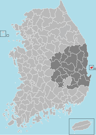
Ulleung County is a county in North Gyeongsang Province, South Korea.

<span class="mw-page-title-main">Ulleungdo</span> South Korean island

Ulleungdo is a South Korean island 120 kilometres east of the Korean Peninsula in the Sea of Japan, formerly known as Dagelet Island or Argonaut Island in Europe. Volcanic in origin, the rocky steep-sided island is the top of a large stratovolcano which rises from the seafloor, reaching a maximum elevation of 984 metres (3,228 ft) at Seonginbong Peak. The island is 9.5 kilometres (6 mi) in length and ten kilometres (6 mi) in width; it has an area of 72.86 km2 (28.13 sq mi). It has a population of 10,426 inhabitants.

<span class="mw-page-title-main">Usan</span> State in East Asia (512–930)

Usan-guk, or the State of Usan, occupied Ulleung-do and the adjacent islands during the Korean Three Kingdoms period. According to the Samguk Sagi, it was conquered by the Silla general Kim Isabu in 512. He is said to have used wooden lions or tigers to intimidate the residents into surrendering. It has been written that the alias of Usan-guk is Ulleung-do. Usan-guk rarely entered into historical records, but appears to have continued a largely autonomous existence until its loss of independence to Goryeo in 930.
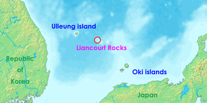
<span class="mw-page-title-main">Tsushima Basin</span> Oceanic Basin in the Sea of Japan

The Tsushima Basin or Ulleung Basin is an oceanic basin located where the Sea of Japan meets the Korea Strait. It lies immediately south of Ulleung-do and Liancourt Rocks, in the eastern end of the South Korean EEZ and the western end of the Japanese EEZ.

<span class="mw-page-title-main">Rusk documents</span> 1951 US diplomatic papers on Japan

The Rusk documents are the official diplomatic correspondence sent by Dean Rusk, the United States Assistant Secretary of State for Far Eastern Affairs, to Yang You-chan, the South Korean ambassador to the U.S. on August 10, 1951.

<span class="mw-page-title-main">Jukdo (island)</span> South Korean island in the Sea of Japan

Jukdo is a small island adjacent to Ulleungdo, South Korea, in the Sea of Japan. It is also known as Jukseodo in Korea and Japan. It lies 2 km (1 mi) east of Ulleungdo, and is the largest island in the group apart from Ulleungdo itself. In 2004, one family of three members was living on the island.

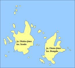
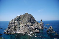
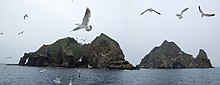
Takeshima (竹島) is the Japanese name for the Liancourt Rocks.

Usan-do is a historical name for an island in the Sea of Japan described in Korean records. It was part of the ancient state of Usan-guk, but its exact identity is disputed. It may refer to:

<span class="mw-page-title-main">An Yong-bok</span> Korean fisherman related to a Korea–Japan dispute

An Yong-bok was a Korean fisherman in 17th century of Joseon Dynasty famous for his travels to Japan. His activities were instrumental in determining fishery rights in the waters of Ulleungdo and the Liancourt Rocks, two islands in the East Sea.

<span class="mw-page-title-main">Liancourt Rocks dispute</span> Territorial dispute over islands between South Korea and Japan

The Liancourt Rocks dispute, also called the Dokdo dispute is a territorial dispute between South Korea and Japan regarding sovereignty over the Liancourt Rocks, a group of small islets in the Sea of Japan. The rocks also go by the names Dokdo and Takeshima. North Korea also claims sovereignty of the islands, but has not pursued its claim to the same extent as the other parties.

ROKS <i>Dokdo</i> Dokdo-class amphibious assault ship

ROKS Dokdo (LPH-6111) is the lead ship of the Dokdo-class amphibious assault ship of the Republic of Korea Navy, launched on 12 July 2005 at the shipyard of Hanjin Heavy Industries & Constructions Co. in Busan. ROKS Dokdo was the flagship of the Fifth Component Flotilla of the Korean Navy until the launch of ROKS Marado in 2018. Previously, this title was held by the 9,000-ton at-sea Underway Replenishment (UNREP) support vessel ROKS Cheonji.

<span class="mw-page-title-main">Postage stamps and postal history of South Korea</span>

This is a survey of the postage stamps and postal history of South Korea.

Dokdo Museum is the name used for two museums in Korea that relate to the Liancourt Rocks, known as Dokdo in Korean. One of the museums is located on Ulleungdo and the other, which opened later, is in Seoul.

<span class="mw-page-title-main">Daehanjiji</span>

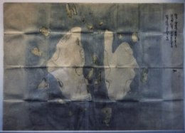
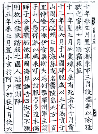
Daehanjiji is an elementary school geography text about the Korean Empire by Hyeon Chae. Hyeon Chae wrote the book in 1899, translating and compiling Japanese and Korean sources. It was published by Gwangmun-sa, Seoul.

<span class="mw-page-title-main">Territorial disputes of Japan</span>

Japan is currently engaged in several territorial disputes with nearby countries, including Russia, South Korea, North Korea, the People's Republic of China, and the Republic of China (Taiwan).
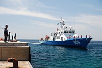
Dokdo Volunteer Garrison was a South Korean paramilitary outpost on the islands of Liancourt Rocks, which are called Dokdo in Korean. South Korea and Japan each claim sovereignty over them. South Korea maintained the garrison from 1953 to 1956.

In Japan, Takeshima Day (竹島の日) is celebrated on February 22 every year since 2005. Public events related to Takeshima are held on this day, and the day is also used to demonstrate Japan's sovereignty over the Liancourt Rocks.

References

South Korea

Japan

37°14′30″N131°52′00″E / 37.24167°N 131.86667°E / 37.24167; 131.86667