| Wachusett Reef | |
|---|---|
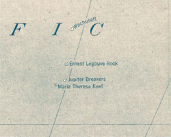 Wachusett Reef on 1921 Pacific map | |
| In-universe information | |
| Type | Phantom island |

Wachusett Reef is a phantom reef in the Antarctic Ocean.
Captain Lambert of the ship Wachusett reported that on June 4, 1899 he passed over a reef which appeared to be of coral formation in approximately latitude 32°18′S151°08′W / 32.300°S 151.133°W . The reef appeared to be about 500 feet (150 m) wide. The bottom showed of a dark gray color with deep blue on both sides of the reef. The depth was estimated at from 5 to 6 fathoms (30 to 36 ft; 9.1 to 11.0 m); unfortunately no soundings were taken. [1]
The 2015 edition of the National Geographic Atlas of the World still shows Wachusett Reef, with a depth of 9 metres (30 ft). [2] Nevertheless, its existence is doubtful, making it a phantom reef. Other nearby historically reported reefs which appear to not exist include Ernest Legouve Reef, Jupiter Reef, and Maria Theresa Reef.