Kingman Reef is a largely submerged, uninhabited, triangle-shaped reef, geologically an atoll, 9.0 nmi (20 km) east-west and 4.5 nmi (8 km) north-south, in the North Pacific Ocean, roughly halfway between the Hawaiian Islands and American Samoa. It has an area of 3 hectares and is a unincorporated territory of the United States in Oceania. The reef is administered by the United States Fish and Wildlife Service as the Kingman Reef National Wildlife Refuge. It was claimed by the US in 1859, and later used briefly as stopover for commercial Pacific flying boat routes in the 1930s, until there was aircraft disaster with one of the flying boats serving the route. It was administered by the Navy from 1934 to 2000, and thereafter the Fish and Wildlife service. It has since become a marine protected area. In the 19th century it was noted as maritime hazard, earning the name Hazard Rocks, and is known to have been hit once in 1876. In the 21st century it has been noted for is marine biodiversity and remote nature.

Palmyra Atoll, also referred to as Palmyra Island, is one of the Northern Line Islands. It is located almost due south of the Hawaiian Islands, roughly one-third of the way between Hawaii and American Samoa. North America is about 3,300 miles northeast and New Zealand the same distance southwest, placing the atoll at the approximate center of the Pacific Ocean. The land area is 4.6 sq mi (12 km2), with about 9 miles (14 km) of sea-facing coastline and reef. There is one boat anchorage, known as West Lagoon, accessible from the sea by a narrow artificial channel.

A phantom island is a purported island which was included on maps for a period of time, but was later found not to exist. They usually originate from the reports of early sailors exploring new regions, and are commonly the result of navigational errors, mistaken observations, unverified misinformation, or deliberate fabrication. Some have remained on maps for centuries before being "un-discovered."
An islet is a very small, often unnamed island. Most definitions are not precise, but some suggest that an islet has little or no vegetation and cannot support human habitation. It may be made of rock, sand and/or hard coral; may be permanent or tidal ; and may exist in the sea, lakes, rivers or any other sizeable bodies of water.

The Coral Sea is a marginal sea of the South Pacific off the northeast coast of Australia, and classified as an interim Australian bioregion. The Coral Sea extends 2,000 kilometres (1,200 mi) down the Australian northeast coast. Most of it is protected by the French Natural Park of the Coral Sea and the Australian Coral Sea Marine Park. The sea was the location for the Battle of the Coral Sea, a major confrontation during World War II between the navies of the Empire of Japan, and the United States and Australia.

The Austral Islands are the southernmost group of islands in French Polynesia, an overseas country of the French Republic in the South Pacific. Geographically, they consist of two separate archipelagos, namely in the northwest the Tupua'i islands consisting of the Îles Maria, Rimatara, Rūrutu, Tupua'i Island proper and Ra'ivāvae, and in the southeast the Bass Islands composed of the main island of Rapa Iti and the small Marotiri. Inhabitants of the islands are known for their pandanus fiber weaving skills. The islands of Maria and Marotiri are not suitable for sustained habitation. Several of the islands have uninhabited islets or rocks off their coastlines. Austral Islands' population is 6,965 on almost 150 km2 (58 sq mi). The capital of the Austral Islands administrative subdivision is Tupua'i.


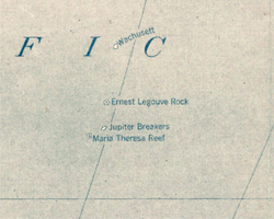
The Ernest Legouve Reef is a phantom reef supposed to be located in the South Pacific, south of French Tuamotu Islands and east of New Zealand. Krauth reports that it is situated at 35°12′S150°40′W.
The Maria Theresa Reef is a supposed reef in the South Pacific ; it appears to be a phantom reef. It is also known as Tabor Island or Tabor Reef on French maps.

Jason was a Norwegian whaling vessel laid down in 1881 by Rødsverven in Sandefjord, Norway, the same shipyard which later built Ernest Shackleton's ship Endurance. The ship, financed by Christen Christensen, an entrepreneur from Sandefjord, was noted for his participation in an 1892-1893 Antarctic expedition led by Carl Anton Larsen.

The Pacific Remote Islands Marine National Monument is a group of unorganized, mostly unincorporated United States Pacific Island territories managed by the United States Fish and Wildlife Service of the United States Department of the Interior and the National Oceanic and Atmospheric Administration (NOAA) of the United States Department of Commerce. These remote refuges are "the most widespread collection of marine- and terrestrial-life protected areas on the planet under a single country's jurisdiction". They protect many endemic species including corals, fish, shellfish, marine mammals, seabirds, water birds, land birds, insects, and vegetation not found elsewhere.

Filippo Reef is a reef that is asserted to be in the Pacific Ocean at 05°30′S151°50′W, 450 kilometres (280 mi) east of Starbuck Island in the Line Islands. The reef was reported by the master of the Italian barque Filippo as having been seen on 28 June 1886. From an unidentified report of breakers dated 1926, it was estimated to have a water depth of only 0.6 to 0.9 metres, and appeared to be about 1.6 kilometres (1.0 mi) long northwest to southeast, and less in width.

The Chesterfield Islands are a French archipelago of New Caledonia located in the Coral Sea, 550 km (300 nmi) northwest of Grande Terre, the main island of New Caledonia. The archipelago is 120 km long and 70 km broad, made up of 11 uninhabited islets and many reefs. The land area of the islands is less than 10 km2.
The Gardner family were a group of whalers operating out of Nantucket, Massachusetts, from the 17th to 19th centuries. Some members of the family gained wider exposure due to their discovery of various islands in the Pacific Ocean. By marriage, they were related to the Coffins, another Nantucket whaling family.

Elizabeth Reef, located at 29°57′25″S159°4′32″E, is a coral reef in the Coral Sea. The reef is separated by a deep oceanic pass, some 47 km wide, from nearby Middleton Reef, both of which are part of the underwater plateau known as the Lord Howe Rise. It is around 150 km from Lord Howe Island and 600 km from the New South Wales coast of Australia. The Environment, Sport and Territories Legislation Amendment Act 1997 included Elizabeth Reef in Australia's Coral Sea Islands Territory.
Wachusett Reef was a phantom reef in the Antarctic Ocean.

The borders of the oceans are the limits of Earth's oceanic waters. The definition and number of oceans can vary depending on the adopted criteria. The principal divisions of the five oceans are the Pacific Ocean, Atlantic Ocean, Indian Ocean, Southern (Antarctic) Ocean, and Arctic Ocean. Smaller regions of the oceans are called seas, gulfs, bays, straits, and other terms. Geologically, an ocean is an area of oceanic crust covered by water.
Sandy Island is a non-existent island that was charted for over a century as being located near the French territory of New Caledonia between the Chesterfield Islands and Nereus Reef in the eastern Coral Sea. The island was included on many maps and nautical charts from as early as the late 19th century. It was removed from French hydrographic charts in 1974. The island gained wide media and public attention in November 2012 when the R/V Southern Surveyor, an Australian research ship, passed through the area and "undiscovered" it. The island was quickly removed from many maps and data sets, including those of the National Geographic Society and Google Maps.

The Coral reefs of the Solomon Islands consists of six major islands and over 986 smaller islands, in Oceania, to the east of Papua New Guinea and northwest of Vanuatu. The Solomon Islands lie between latitudes 5° and 13°S, and longitudes 155° and 169°E. The distance between the westernmost and easternmost islands is about 1,500 km (930 mi). The Santa Cruz Islands are situated north of Vanuatu and are especially isolated at more than 200 km (120 mi) from the other islands. The Solomon Islands has the 22nd largest Exclusive Economic Zone of 1,589,477 km2 (613,701 sq mi) of the Pacific Ocean.