The Klein Bonaire islet, which sits within the rough crescent formed by the main island, is 6 square kilometres (1,483 acres) and extremely flat, rising no more than two meters above the sea. The only structures on the island are some ruins of slave huts (small, single-room structures dating to the region's period of slavery), and a small open shelter on the beach facing Bonaire. The island has no running water or sanitation facilities.
All of Klein Bonaire is visible from hills on the leeward side of Bonaire.
History
In 1868, Klein Bonaire was sold to Angel Jeserun and remained in private hands until 1999. During this period the native trees were removed, resulting in a scrub growth across the island. The development of Klein Bonaire was attempted a few times prior to its establishment as a marine preserve, the last unsuccessful attempt being in 1995.
Concerned locals rallied to save Klein Bonaire and raise funds to do so and The Foundation for the Preservation of Klein Bonaire (FPKB) was born. Through efforts of the FPKB and other concerned parties, and with monies from the Department of the Interior and Kingdom Affairs of the Netherlands, the World Nature Fund of the Netherlands and FPKB, the island was successfully purchased in 1999 for 9 million Netherlands Antillean guilder (US$5 million).
Klein Bonaire is now part of the Bonaire National Marine Park.[2] Long-term plans include reintroduction of the native vegetation.
The distance from the shore of Bonaire to the shore of Klein Bonaire is about 800 metres (0.50 miles) at the nearest point. This span is frequently traversed by private and commercial boats and can be done by kayak with some difficulty. The primary attraction for visitors is scuba diving and snorkeling the pristine coral reef surrounding the islet. Numbered yellow painted rocks near the open shelter show where divers can cross low points on the reef, which is very close to the beach. When facing the water at the rocks the current runs from right to left.
Gallery
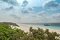
Klein Bonaire beach
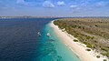
Aerial view of Klein Bonaire beach
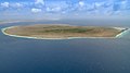
Aerial view of Klein Bonaire
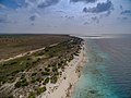
Another aerial view with Bonaire in the background
This page is based on this Wikipedia article Text is available under the CC BY-SA 4.0 license; additional terms may apply. Images, videos and audio are available under their respective licenses.


