
The Southern District is one of the 18 districts of Hong Kong. It is located in the southern part of Hong Kong Island. It had a population of 274,994 in 2016.

The Po Toi Islands are a small group of islands with a population of around 200, south-east of Hong Kong Island, off Stanley, in Hong Kong. The main island of the group is Po Toi Island. Administratively, they are part of Islands District.

Tung Ping Chau is an island in Hong Kong, part of Hong Kong UNESCO Global Geopark. It is also known as Ping Chau (平洲). Tung is prepended to the name at times so as to avoid possible confusion with Peng Chau, another island in Hong Kong with an identically pronounced name in Cantonese. Administratively, the island is part of the Tai Po District in the New Territories.
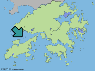
The Brothers or Mo To Chau consist of two islands in Hong Kong, Siu Mo To and Tai Mo To. The two islands have been leveled to avoid affecting aviation of the nearby Hong Kong International Airport. Administratively, they are under the jurisdiction of Tuen Mun District.

Ap Chau, also known as Robinson Island, with a size of 0.04 km² is an island in the Crooked Harbour, in the north-eastern New Territories of Hong Kong. It is located in Ap Chau Bay. Islets located close by include Ap Chau Pak Tun Pai, Ap Chau Mei Pak Tun Pai, Ap Lo Chun, Ap Tan Pai and Kau Tau Shek.

Ap Lo Chun is a small island in the New Territories of Hong Kong. It is under the administration of North District.

Rocky Harbour or Leung Shuen Wan Hoi is a harbour at the south-east of Sai Kung Peninsula, Hong Kong.

Double Haven or Yan Chau Tong is a harbour enclosed by Double Island, Crescent Island and Crooked Island within the north-eastern New Territories of Hong Kong. It is known for its scenery and natural environment, and for the calm seas from which its English name derives. Double Haven contains many deep red coloured rocks because of iron oxide.

Port Shelter, known in Cantonese as Ngau Mei Hoi, is a harbour south of Sai Kung Peninsula in Hong Kong. The water body connects to Inner Port Shelter, as well as Hebe Haven (白沙灣), Rocky Harbour (糧船灣海) and other water body. Outer Port Shelter, is situated at the mouth of the harbour.

Sharp Island or Kiu Tsui Chau is the largest island in the Kiu Tsui Country Park located at Port Shelter of Sai Kung, Hong Kong. The area is most known for fishing, swimming as well as diving. Sharp Island is under the administration of Sai Kung District.

Basalt Island or Fo Shek Chau is an island of Hong Kong and administratively part of Sai Kung District. Together with Wang Chau and Bluff Island, it forms the Ung Kong Group and is part of Hong Kong Global Geopark.
Jin Island or Tiu Chung Chau is an island in the Port Shelter, the New Territories, Hong Kong. Administratively it is part of the Sai Kung District.
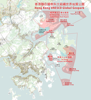
Hong Kong UNESCO Global Geopark, formerly Hong Kong National Geopark (香港國家地質公園), was inaugurated on 3 November 2009. It is a single entity of land area over 150 km2 across parts of the eastern and northeastern New Territories. On 18 September 2011, UNESCO listed the geopark as part of its Global Geoparks Network.

Wang Chau is an island of Hong Kong. Administratively, it is part of Sai Kung District.

Tsam Chuk Wan is a bay of the Sai Kung Peninsula in Hong Kong. By extension, it is also the name of the area around the bay. Tsam Chuk Wan Village (斬竹灣村) is one of the villages located within this area.

Kau Pei Chau is an uninhabited islet located off the coast of Hong Kong Island on its southeastern end, about 50 metres (165 feet) off the tip of Cape D'Aguilar. Administratively, it is part of Southern District. Kau Pei Chau has a length of 1.34 kilometres (0.83 mi). It is located directly south of the Cape D’Aguilar Marine Reserve.

Shelter Island, known in Cantonese as Ngau Mei Chau, is an island located in the water body Port Shelter, in the Sai Kung District, the New Territories, Hong Kong S.A.R., China.
Tai Tau Chau also known for its less popular name Urn Island, is an island in the water body Sham Tuk Mun (深篤門), Sai Kung District, Hong Kong. Inner Port Shelter and Rocky Harbour are in close proximity to the island.
Pak Ka Chau is an islet of the North District of Hong Kong. It is located within Double Haven, south of Kat O.

