Related Research Articles
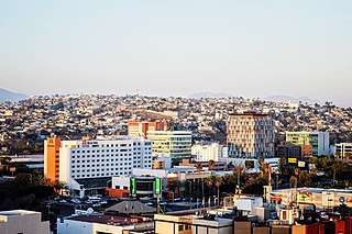
Tijuana is a city in Baja California, Mexico. It is part of the San Diego–Tijuana transborder urban agglomeration and the larger Southern California megalopolis. As the 2nd-largest city in Mexico and center of the 6th-largest metro area in Mexico, Tijuana exerts a strong influence in education and politics, in transportation, culture, art, and manufacturing and as a migration hub. Currently one of the fastest-growing metropolitan areas in Mexico, Tijuana is rated as a "High Sufficiency" global city by the Globalization and World Cities Research Network. As of September 2019, the city of Tijuana had a population of 1,810,645, with its metropolitan area containing a population of 2,157,853 as of 2020, an estimated 2,002,000 within the urban area.

Morelos, officially the Free and Sovereign State of Morelos, is one of the 32 states which comprise the Federal Entities of Mexico. It is divided into 36 municipalities and its capital city is Cuernavaca.

Ixtaczoquitlán is a city in the Mexican state of Veracruz. It is 2 kilometres (1.2 mi) from Orizaba. It is close to the Fortín–Orizaba railroad and stands on Federal Highways 180 & 190. It serves as the municipal seat for the surrounding municipality of the same name. It is in the Orizaba-Córdoba region and is contiguous with these two as well as with the municipality of Fortín.

Atlatlahucan is a city in the Mexican state of Morelos. The name means Place of red or brown water, and today the water is stored in a type of cistern called a jagüey. To the north is the State of Mexico, south is Cuautla, east is Yecapixtla, and west are Tlayacapan and Yautepec. It stands at 18°56′N98°54′W, at a mean height of 1,656 metres above sea level. The municipality covers 71 km2.
Huitzilac is a city in the Mexican state of Morelos. It stands at 19°01′42″N99°16′02″W and at an altitude of 2,561 m. (8,402 ft.) above sea level.

Miacatlán is a city and municipal seat of the municipality of Miacatlán in the Mexican state of Morelos. It stands at 18°45′N99°21′W.
Xochitepec is a municipio (municipality) of the state of Morelos, in central Mexico. Xochitepec is also the name of its principal township and seat of the municipal government. It is located approximately 13 km (8.1 mi) to the south of the capital of Morelos, Cuernavaca, on the southern outskirts of that city's greater metropolitan area.

Yautepec is a municipality located in the north-central part of the Mexican state of Morelos. The municipal seat is the city of Yautepec de Zaragoza. It stands at 18°53′N99°04′W.
Cuyamaca is a region of eastern San Diego County. It lies east of the Capitan Grande Indian Reservation in the western Laguna Mountains, north of Descanso and south of Julian. Named for the 1845 Rancho Cuyamaca Mexican land grant, the region is now dominated by the 26,000-acre (110 km2) Cuyamaca Rancho State Park. Within the park is the prominent Cuyamaca Peak, the second-highest mountain in San Diego County at 6,512 feet (1,984.9 m).

Nuevo Laredo is a city in the Municipality of Nuevo Laredo in the Mexican state of Tamaulipas. The city lies on the banks of the Rio Grande, across from the American city of the same name. The 2010 census population of the city was 373,725. Nuevo Laredo is part of the Laredo-Nuevo Laredo Metropolitan Area with a population of 636,516. The municipality has an area of 1,334.02 km2 (515.07 sq mi). Both the city and the municipality rank as the third largest in the state.

Municipalities are the second-level administrative divisions of Mexico, where the first-level administrative division is the state. They should not be confused with cities or towns that may share the same name as they are distinct entities and do not share geographical boundaries. As of January 2021, there are 2,454 municipalities in Mexico, excluding the 16 boroughs of Mexico City.

Tijuana Municipality is a municipality in the Mexican state of Baja California. Its municipal seat is located in the city of Tijuana. According to the 2020 census, the municipality had a population of 1,922,523. Luis Arturo González Cruz of the MORENA is the current municipal president. The municipality comprises the largest part of the Tijuana metropolitan area.
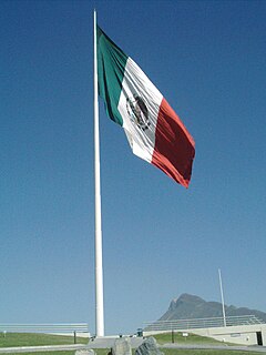
The banderas monumentales are a collection of tall flagpoles containing large flags of Mexico located throughout Mexico. They are part of a program started in 1999 under President Ernesto Zedillo that is currently administered by the Secretariat of National Defense. The main feature of these monuments is a giant Mexican flag flying off a 50-meter-high (160-ft) flagpole. The size of the flag was 14.3 by 25 metres and it was flown on a pole that measured 50 metres (160 ft) high. In the time after the decree was issued, many more banderas monumentales have been installed throughout the country in various sizes. Many of the locations were chosen due to significant events in Mexican history that occurred there.

The Municipality of the District of Chester is a Nova Scotia district municipality occupying the northeastern half of Lunenburg County, Canada. Government in the province has only two tiers: provincial and municipal. The province is divided into 50 municipalities.
The Agua Caliente Racetrack is a greyhound racing and former horse racing track in Tijuana, Baja California, Mexico. It opened in December 1929 at a cost of $2.5 million.

Market Square is a three-block outdoor plaza lined with shops, and restaurants in downtown San Antonio, Texas. Market Square is the largest Mexican market in the United States. The "El Mercado" section has 32 specialty shops and the "Farmer's Market Plaza" section has 80. "Mi Tierra Cafe Y Panaderia" and "La Margarita Mexican Restaurant & Oyster Bar" are the major eateries, but snack and specialty foods are available at other shops. Market Square is the site of Cinco de Mayo in central San Antonio and many other fiestas throughout the year.
Valle de las Palmas is located between two hamlets Espuela and Seco in the municipalities of Tijuana and Tecate, Baja California, Mexico. It is the site of a long-term planned urban development which would take advantage of proximity to the existing cities of Tijuana to the north west and Mexicali to the north east to create a similar sized city of one million people by the year 2030, on Mexican Federal Highway 3 around an existing industrial park and university campus Unidad Valle De Las Palmas. The first project in Valle de las Palmas, named Valle San Pedro, is proposed by the Mexican Federal Government, the State of Baja California, Urbi and Banobras. It has been certified as the first Integral Sustainable Urban Development or DUIS in Mexico, which establishes criteria in collaboration with Interamerican Development Bank IDB to evaluate projects that will receive inter-secretarial technical support and public investment. The locality reported a population of 1,860 inhabitants in the 2010 federal census. It is located at an altitude of 282 m. above sea level.
The Autonomous University of Baja California is a public institution of higher education in the Mexican state of Baja California. UABC is one of the 43 state universities throughout Mexico as part of the country's state university system. Its headquarters are located in the city of Mexicali.

Ecatepec, officially Ecatepec de Morelos, is a municipality in the State of Mexico. The municipal seat is San Cristóbal Ecatepec.

Rio Alamar or Arroyo de Alamar is a river mainly in northern Baja California, Mexico with a small portion in California, United States. The stream is formed by the confluence of Cottonwood Creek and Tecate Creek a short distance north of the Mexico–United States border. It flows generally west for about 25 kilometres (16 mi) through the San Ysidro Mountains and the Tijuana urban area before joining with the Arroyo de las Palmas in central Tijuana, to form the Tijuana River.
References
- ↑ "SIMPATT | Sistema Municipal de Parques Tematicos de Tijuana". www.simpatt.tijuana.gob.mx. Retrieved 2019-03-09.
Coordinates: 32°29′56″N116°56′24″W / 32.499°N 116.940°W
| | This garden-related article is a stub. You can help Wikipedia by expanding it. |