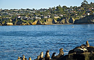
Transportation in San Diego

Last updated

Transportation in San Diego consists of a variety of air, road, sea, and public transportation options.

Contents

Public transportation

San Diego Trolley at San Diego State University (SDSU) SDSU Green Line.jpg
San Diego Trolley at San Diego State University (SDSU)

San Diego is served by the San Diego Trolley, bus (operated by the San Diego Metropolitan Transit System), COASTER, and Amtrak. The trolley primarily serves downtown and surrounding urban communities, Mission Valley, east county, the coastal south bay, and the international border. A planned Mid-Coast line will operate from Old Town to University City along the Interstate 5 Freeway. There are also plans for a Silver Line to expand trolley service downtown.[ citation needed ]

The Amtrak and COASTER trains currently run along the coastline and connect San Diego with Los Angeles, Orange County, San Bernardino, Riverside, and Ventura via Metrolink. There are two Amtrak stations in San Diego, in Old Town and Downtown.

The bus is available along almost all major routes; however, a large number of bus stops are concentrated in central San Diego. Typical wait times vary from 15 to 60 minutes, depending on the location and route . Trolleys arrive at each station every 7 to 30 minutes (depending on time of day and which trolley line is used).[ citation needed ] Ferries are also available every half hour crossing San Diego Bay to Coronado.

Public transportation statistics

The average amount of time people spend commuting with public transit in San Diego, CA, for example to and from work, on a weekday is 70 min. 23% of public transit riders, ride for more than 2 hours every day. The average amount of time people wait at a stop or station for public transit is 16 min, while 29% of riders wait for over 20 minutes on average every day. The average distance people usually ride in a single trip with public transit is 11.2 km, while 30% travel for over 12 km in a single direction. [1]

Cycling

The dry and mild climate of San Diego makes cycling a convenient and pleasant year-round option. The city has some segregated cycle facilities, particularly in newer developments, however the majority of road facilities specifically for bicycles are painted on regular roadways, covering over 1,570 miles throughout San Diego County. [2] The city's hilly, canyoned terrain and long average trip distances—brought about by strict low-density zoning laws—somewhat restrict cycling for utilitarian purposes.

In 2014 of .9% of commuters traveled by bicycle, below the average 1% for large U.S. cities. Also in 2014, San Diego experienced 6.8 bicyclist fatalities per 10,000 cyclist commuters, the average for all large cities was 4.7. [3]

A bicycle sharing system called Decobike was instituted in 2015. [4]

Air

San Diego has two major international airports entirely or extending into its city limits:

San Diego International Airport, also known as Lindbergh Field, is the primary commercial airport serving San Diego. It is the busiest single-runway airport in the world. [5] It serves over 24 million passengers every year, and is located on San Diego Bay three miles (4.8 km) from downtown. There are scheduled flights to the rest of the United States, Canada, Japan, Mexico, United Kingdom, Germany, and Switzerland. It serves as a focus city for Southwest Airlines and Alaska Airlines. Voters rejected a proposal to move the airport to Miramar Marine Corps Air Station in November 2006. [6]

Since December 9, 2015, the Cross Border Xpress terminal in Otay Mesa has given direct access to Tijuana International Airport, with passengers walking across the U.S.–Mexico border on a footbridge to catch their flight on the Mexican side. It is the only airport in the world with terminals located on the territory of two countries.

Other airports include Brown Field Municipal Airport (Brown Field) and Montgomery Field.

Sea

The Port of San Diego manages the maritime operations of San Diego harbor. Cruise ships arrive and depart from San Diego's cruise ship terminal on B Street Pier. Carnival Cruise Lines and Holland America have home port cruise ships in San Diego during the winter season. A second cruise terminal on Broadway Pier opened in 2010.

San Diego is home to General Dynamics' National Steel and Shipbuilding Company (NASSCO), the largest shipyard on the West Coast of the United States. [7] It is capable of building and repairing large ocean-going vessels. The yard constructs commercial cargo ships and auxiliary vessels for the U.S. Navy and Military Sealift Command, which it has served since 1960.

Roads

Cabrillo Freeway leading into Downtown San Diego Cabrillo Freeway.jpg
Cabrillo Freeway leading into Downtown San Diego

The streets and highways of San Diego reflect the automotive city development as well as its "urban sprawl" historic growth pattern. Major freeways were built and repeatedly expanded to serve the needs of commuters [8] coming into the city from the suburban regions of North County, South Bay, and East County, as well as the Tijuana metropolitan area. The importance of tourism to the city also stimulated the development of roads, since 70% of tourists visiting San Diego arrive by car. [9]

Major highways

Interstates

San Diego is the terminus of three primary interstate highways. The region is also served by one three-digit auxiliary interstate.

I-5 (CA).svg Interstate 5
San Diego Freeway
Interstate 5 begins at the U.S.-Mexico border and heads north through downtown and the coastal portion of the city, continuing through North County to Los Angeles.
I-8 (CA).svg Interstate 8
Ocean Beach Freeway
Kumeyaay Highway
Interstate 8 has its western terminus at the intersection with Sunset Cliffs Boulevard in Ocean Beach, and heads east through Mission Valley and San Diego's eastern suburbs before heading through East County to the Imperial Valley and Arizona.
I-15 (CA).svg Interstate 15
Escondido Freeway
Interstate 15 begins at I-8 in Mission Valley. It heads northeast through the city's inland suburbs before continuing through the Inland Empire to Las Vegas.
I-805 (CA).svg Interstate 805
Jacob Dekema Freeway
Interstate 805 is a bypass of Interstate 5 that begins just north of the Mexican border in San Ysidro and rejoins I-5 near Del Mar, at an intersection known as "The Merge".

California State Routes

State highways in San Diego include the following:

California 11.svg State Route 11
SR 11 is a short freeway, running from the SR 125/SR 905 interchange east to its current terminus at Enrico Fermi Drive in Otay Mesa. In the future SR 11 will extend east as a toll road to the Otay Mesa East Port of Entry.
California 15.svg State Route 15
Escondido Freeway
SR 15 is a continuation of I-15, running from the I-8/I-15 interchange south to I-5 in Southeast San Diego near the 32nd Street Naval Station.
California 52.svg State Route 52
San Clemente Canyon Freeway
Mount Soledad Freeway
SR 52 connects La Jolla with East County through Santee and SR 125.
California 54.svg State Route 54
South Bay Freeway
Jamacha Boulevard
SR 54 begins at I-5 in National City, then travels northeast to SR 125 near Spring Valley. SR 54 then continues northeast on Jamacha Road to El Cajon.
California 56.svg State Route 56
Ted Williams Freeway
SR 56 connects I-5 with I-15 through Carmel Valley and Rancho Peñasquitos.
California 67.svg State Route 67
San Vicente Freeway
SR 67 runs north away from I-8 and El Cajon towards Lakeside, where it becomes a smaller road and continues north towards Ramona.
California 75.svg State Route 75
San Diego-Coronado Bridge
Silver Strand Boulevard
Palm Avenue
SR 75 spans San Diego Bay as the San Diego-Coronado Bridge, then heads south along the Silver Strand from Coronado to South San Diego, where it becomes Palm Avenue
California 78.svg State Route 78
San Pasqual Valley Road
SR 78 is present within the city limits of San Diego from San Pasqual Road to Guejito Truck Trail. SR 78 continues west to Escondido and Oceanside and the eastern continuation heads toward Brawley in Imperial County and up to I-10 near Blythe in Riverside County.
California 94.svg State Route 94
Martin Luther King Jr. Freeway
Campo Road
SR 94 connects downtown with I-805, SR 15, and East County.
California 125.svg State Route 125
South Bay Expressway
SR 125 connects East County cities from SR 905 near the Otay Mesa Port of Entry north to Santee. The segment of SR 125 from SR 11 and SR 905 to SR 54 is a toll road, the South Bay Expressway.
California 163.svg State Route 163
Cabrillo Freeway
Dean E. Beattie Memorial Highway
SR 163 connects downtown with the northeast part of the city, intersects I-805 and merges with I-15 at Miramar. The stretch of SR 163 that passes through Balboa Park is San Diego's oldest freeway, and has been called one of America's most beautiful parkways. [10]
California 905.svg State Route 905
Otay Mesa Freeway
SR 905 connects I-5 and I-805 to the Otay Mesa Port of Entry.

.

Major streets

See also

Related Research Articles

<span class="mw-page-title-main">Transportation in Boston</span> Overview of transportation in Boston, Massachusetts, United States

Transportation in Boston includes roadway, subway, regional rail, air, and sea options for passenger and freight transit in Boston, Massachusetts. The Massachusetts Port Authority (Massport) operates the Port of Boston, which includes a container shipping facility in South Boston, and Logan International Airport, in East Boston. The Massachusetts Bay Transportation Authority (MBTA) operates bus, subway, short-distance rail, and water ferry passenger services throughout the city and region. Amtrak operates passenger rail service to and from major Northeastern cities, and a major bus terminal at South Station is served by varied intercity bus companies. The city is bisected by major highways I-90 and I-93, the intersection of which has undergone a major renovation, nicknamed the Big Dig.

<span class="mw-page-title-main">Transportation in Los Angeles</span> Complex multimodal regional, national and international hub for passenger and freight traffic

Los Angeles has a complex multimodal transportation infrastructure, which serves as a regional, national and international hub for passenger and freight traffic. The system includes the United States' largest port complex; an extensive freight and passenger rail infrastructure, including light rail lines and rapid transit lines; numerous airports and bus lines; vehicle for hire companies; and an extensive freeway and road system. People in Los Angeles rely on cars as the dominant mode of transportation, but since 1990 the Los Angeles County Metropolitan Transportation Authority has built over one hundred miles (160 km) of light and heavy rail serving more and more parts of Los Angeles and the greater area of Los Angeles County. As a result, Los Angeles was the last major city in the United States to get a permanent rail system installed.

<span class="mw-page-title-main">Transportation in Seattle</span> Overview of transportation modes and routes in Seattle, Washington, U.S.

Transportation in Seattle is largely focused on the automobile like many other cities in western North America; however, the city is just old enough for its layout to reflect the age when railways and trolleys predominated. These older modes of transportation were made for a relatively well-defined downtown area and strong neighborhoods at the end of several former streetcar lines, now mostly bus lines.

<span class="mw-page-title-main">Transportation in Philadelphia</span>

Transportation in Philadelphia involves the various modes of transport within the city and its required infrastructure. In addition to facilitating intracity travel, Philadelphia's transportation system connects Philadelphia to towns of its metropolitan area and surrounding areas within the Northeast megalopolis.

<span class="mw-page-title-main">Transportation in Portland, Oregon</span> Overview of movement of goods and passengers in Portland

Like transportation in the rest of the United States, the primary mode of local transportation in Portland, Oregon is the automobile. Metro, the metropolitan area's regional government, has a regional master plan in which transit-oriented development plays a major role. This approach, part of the new urbanism, promotes mixed-use and high-density development around light rail stops and transit centers, and the investment of the metropolitan area's share of federal tax dollars into multiple modes of transportation. In the United States, this focus is atypical in an era when automobile use led many areas to neglect their core cities in favor of development along interstate highways, in suburbs, and satellite cities.

Portland is "an international pioneer in transit orientated developments."

<span class="mw-page-title-main">Transportation in New York City</span> Overview of urban transportation network

The transportation system of New York City is a network of complex infrastructural systems. New York City, being the most populous city in the United States, has a transportation system which includes one of the largest and busiest subway systems in the world; the world's first mechanically ventilated vehicular tunnel; and an aerial tramway. New York City is home to an extensive bus system in each of the five boroughs; citywide and Staten Island ferry systems; and numerous yellow taxis and boro taxis throughout the city. Private cars are less used compared to other cities in the rest of the United States.

<span class="mw-page-title-main">Transportation in the San Francisco Bay Area</span> Overview of transportation in the San Francisco Bay Area, California, United States

People in the San Francisco Bay Area rely on a complex multimodal transportation infrastructure consisting of roads, bridges, highways, rail, tunnels, airports, seaports, and bike and pedestrian paths. The development, maintenance, and operation of these different modes of transportation are overseen by various agencies, including the California Department of Transportation (Caltrans), the Association of Bay Area Governments, San Francisco Municipal Transportation Agency, and the Metropolitan Transportation Commission. These and other organizations collectively manage several interstate highways and state routes, eight passenger rail networks, eight trans-bay bridges, transbay ferry service, local and transbay bus service, three international airports, and an extensive network of roads, tunnels, and bike paths.

<span class="mw-page-title-main">Transportation in Pittsburgh</span> Transportation in Pittsburgh, Pennsylvania, United States

Transportation in Pittsburgh, Pennsylvania is different than in many other major American cities. A large metropolitan area that is surrounded by rivers and hills, Pittsburgh has an infrastructure system that has been built out over the years to include roads, tunnels, bridges, railroads, inclines, bike paths, and stairways; however, the hills and rivers still form many barriers to transportation within the city.

This is a documentation of the routes, highways, parking requirements, or anything related to transportation in Houston.

<span class="mw-page-title-main">Transportation in San Diego County</span>

The following is a list of transportation options in San Diego County, California.
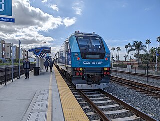
<span class="mw-page-title-main">Old Town Transit Center</span> Passenger train and bus station in San Diego, California, United States

Old Town Transit Center, also known as San Diego–Old Town station or Old Town San Diego station, is an intermodal transportation station located in the Old Town neighborhood of San Diego, California. It is served by Amtrak's Pacific Surfliner, the COASTER commuter rail service, and the San Diego Trolley, as well as numerous San Diego Metropolitan Transit System bus lines.

<span class="mw-page-title-main">Transportation in California</span> Overview of the transport in the State of California

California's transportation system is complex and dynamic. Although known for its car culture and extensive network of freeways and roads, the state also has a vast array of rail, sea, and air transport. Several subway, light rail, and commuter rail networks are found in many of the state's largest population centers. In addition, with the state's location on the West Coast of the United States, several important ports in California handle freight shipments from the Pacific Rim and beyond. A number of airports are also spread out across the state, ranging from small general aviation airports to large international hubs like Los Angeles International Airport and San Francisco International Airport.

<span class="mw-page-title-main">San Diego–Tijuana</span> Transborder agglomeration of the Californias

Transportation in Florida includes a variety of options, including Interstate Highways, U.S. Highways, and Florida State Roads; Amtrak and commuter rail services; airports, public transportation, and sea ports, in a number of the state's counties and regions.

<span class="mw-page-title-main">Transportation in Greater Los Angeles</span> Complex multimodal regional, national and international hub for passenger and freight traffic

Greater Los Angeles has a complex multimodal transportation infrastructure, which serves as a regional, national and international hub for passenger and freight traffic. The transportation system of Greater Los Angeles includes the United States' largest port complex, seven commuter rail lines, Amtrak service, a subway system within the city of Los Angeles, and numerous highways. Los Angeles is integrated into the Interstate Highway System by Interstate 5, Interstate 10, and Interstate 15, along with numerous auxiliary highways and state routes. Bus service is also included locally within the area by numerous local government agencies. Subways and light commuter rail lines are present within Los Angeles proper, allowing mass transportation within the city. Commuter railroads are run by Metrolink. Amtrak has numerous railroad lines that connect Los Angeles to the rest of the country.

<span class="mw-page-title-main">Transportation in Chicago</span> Overview of transportation in the city of Chicago, Illinois

Chicago, Illinois, is the third-largest city in the United States and a world transit hub. The area is served by two major airports, numerous highways, elevated/subway local train lines, and city/suburban commuter rail lines; it is the national passenger rail hub for Amtrak routes, and also the main freight rail hub of North America.

<span class="mw-page-title-main">Transportation in Jacksonville, Florida</span> Overview of transportation in Jacksonville, Florida

The Jacksonville transportation network includes ground, air, and sea options for passenger and freight transit. The Jacksonville Port Authority (Jaxport) operates the Port of Jacksonville, which includes container shipping facilities at Blount Island Marine Terminal, the Talleyrand Marine Terminal and the Dames Point Marine Terminal. Jacksonville Aviation Authority managers Jacksonville International Airport in Northside, as well as several smaller airports. The Jacksonville Transportation Authority (JTA) operates bus, people mover, and park-n-ride services throughout the city and region. A major bus terminal at the intermodal Rosa Parks Transit Station serves as JTA's main transit hub. Various intercity bus companies terminate near Central Station. Amtrak operates passenger rail service to and from major cities throughout North America. The city is bisected by major highways, I-95 and I-10, I-295 creates a full beltway around the city.

Atlanta's transportation system is a complex infrastructure of several systems, including 47.6 miles of heavy rail, 91 bus transit routes, 1,600 licensed taxis, a comprehensive network of freeways, the world's busiest airport and over 45 miles of bike paths.

<span class="mw-page-title-main">Transportation in the Sacramento metropolitan area</span> Complex multi-modal network moving people and goods in the region of California’s state capital

Transportation in the Sacramento metropolitan area consists of a variety of different modes of travel in El Dorado County, Placer County, Sacramento County, and Yolo County, which are the four counties that comprise the Sacramento metropolitan area.

<span class="mw-page-title-main">Transportation in Cleveland</span>

The transportation system of Cleveland is a network that includes several modes of transportation including sidewalks, roads, public transit, bicycle paths and regional and international airports.

References

  1. "San Diego Public Transportation Statistics". Global Public Transit Index by Moovit. Retrieved June 19, 2017. CC-BY icon.svg Material was copied from this source, which is available under a Creative Commons Attribution 4.0 International License.
  2. https://www.icommutesd.com/Bike/BikeMap.aspx
  3. https://www.bikewalkalliance.org/storage/documents/reports/2014BenchmarkingReport.pdf [ bare URL PDF ]
  4. Peterson, Mike (2015-08-07). "How San Diego's new bike sharing works". San Diego Union-Tribune. Retrieved 22 May 2016.
  5. Downey, Dave (September 4, 2017). "FAA chief says region right to consider bases". North County Times . Retrieved September 4, 2017.
  6. Craver, Joe W. (November 19, 2006). "A clear rejection on Miramar, so..." San Diego Union-Tribune . Retrieved April 22, 2009.
  7. "Nassco Seeks to Parlay Power Plant Into Major Ship Contract". Los Angeles Times. 25 January 1986. Retrieved March 29, 2011.
  8. Journal of San Diego History, vol. 41, no. 3, Summer 1995
  9. San Diego Union-Tribune, May 28, 2004
  10. Marshall, David. San Diego's Balboa Park. Arcadia Publishing. 2007.