Carmel Valley, San Diego

Last updated
Carmel Valley
Carmel Valley San Diego 2.JPG
View from the south
CVmap.jpg
Carmel Valley community boundaries and surrounding communities
Location map Northwestern San Diego.png
Red pog.svg
Carmel Valley
Location within Northwestern San Diego
Location map Northeastern San Diego.png
Red pog.svg
Carmel Valley
Location within Northeastern San Diego
Coordinates: 32°56′37″N117°12′32″W / 32.9436607°N 117.2088167°W / 32.9436607; -117.2088167
Country United States
State California
County San Diego
City San Diego
Government
  TypeCA District 49
Population
 (2006) [1]
  Total42,047
Time zone UTC-8 (PST)
  Summer (DST) UTC-7 (PDT)
ZIP Code
92130
Area code 858

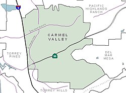
Carmel Valley is a suburban planned community in the northwestern corner of San Diego, California, United States. [2] The community is composed of commercial offices, residential units, hotels, retail stores and restaurants.

Contents

History

Ahwel-Awa

Native American Kumeyaay history within the area has been documented to 7,000 years ago, which was adjacent to a Kumeyaay village west of El Camino Real near the San Dieguito River in North City at the time of European contact with the Spanish known as Ahwel-Awa or ‘aqwilawa, [3] [4] meaning "twine house". [5] The Portolá expedition in 1769, described it as "a large village... and many well built houses with grass roofs". The village were referred to various names by the Spanish such as Sellegua or Jellegua, and were given Christian names under Spanish rule such as San Jacome De la Marca, La Poza de Ozuna, or San Dieguito (name for the region). [4]

Ahwel-Awa was the ancestral home of the Kwitlp clan of the Ipai-Kumeyaay people who spoke the Ipai dialect, and were one of the first Kumeyaay clans to convert to Catholicism in the 1770s under the leadership of Jamacuain "Benito" Culip, who was the kwaapay (leader) of the clan. [5]

Cordero

After the Mexican War of Independence, the area was known to locals as Cordero as land grants were distributed to rancheros to promote settlement and dispossessed many local Kumeyaay peoples of their rights to the land. [6] The Kwitlp clan were relocated inland into what is today, the Mesa Grande Band of Diegueno Mission Indians under the Quilp surname. [7] The name Cordero comes from men with this surname who settled in the area in 1770s (Joaquin Ignacio, Francisco, Mariano Antonio, the sources also contain references to "Cordero brothers" that participated in the Portolá expedition), a ranch house owned by one or more of them was located to the east of El Camino Real and south of Carmel Valley Road. [8]

Following the Mexican-American War and the California Gold rush, the area developed to support agriculture and horse farms. [6] Some equestrian facilities remain in the area.

Carmel Valley

The name Carmel Valley comes from the Catholic Sisters of Mercy, who in 1905 had established a dairy farm (Mercy Hospital Farm) [9] and monastery [10] in the lower McGonigle Canyon. The Sisters of Mercy had named a nearby hill Mount Carmel after a Biblical place [11] near Jerusalem [9] when they came to San Diego in 1890s and were given 1,000 acres in the area by the McGonigle family in exchange for health care (Sisters established the Mercy Hospital). [12] When Robert Stevens acquired the farm in 1940s, he changed its name to Mount Carmel Ranch; the name Carmel got attached to the valley, at first starting with the lower portion of the McGonigle Canyon. [9] Sisters of Mercy had also established the Carmel Valley Cemetery in 1900 (to the north of the modern SR 56). [12]

Carmel Valley is one of the newer neighborhoods of the City of San Diego, California. The community was formed by the City of San Diego on February 1, 1975. [13] The construction later began in 1983 as farms were replaced by residential communities. [14] Although the area was known locally as Carmel Valley, in 1974 the area was given the institutional name North City West in the master plan. The name Carmel Valley was adopted by residents in 1991 to replace the old one. [10]

Geography

Carmel Valley is bordered to the north by the North City Future Urbanizing Area (NCFUA) and Pacific Highlands Ranch; to the south by Los Peñasquitos Canyon Preserve and Torrey Hills; to the east by Pacific Highlands Ranch and Del Mar Mesa; and to the west by Interstate 5 and Torrey Pines. Nearby is the Torrey Pines State Natural Reserve, where one of two stands of the endangered Torrey Pine is found to occur. The area overlooks the ocean and is located in the hills.

While many people in the area are now referring to the entire 92130 ZIP code as Carmel Valley, the actual boundaries of the community remain unchanged from the original community plan. The remainder of the 92130 ZIP code is filled by the surrounding communities of Del Mar Mesa, Pacific Highlands Ranch, and Torrey Hills. Torrey Highlands, the easternmost section of Del Mar Mesa, is considered to be a part of Carmel Valley and the boundary between Carmel Valley and Rancho Peñasquitos.

Demographics

According to the San Diego County Assessor's Office's 2006 estimates, [1] there were 42,047 people living in the neighborhood, a 49.2% increase from 2000. The racial makeup of the neighborhood was 70.6% White, 18.0% Asian & Pacific Islander, 7.0% Hispanic, 3.4% from other races, 0.89% African American, and 0.001% American Indian.

The neighborhood is diverse in age with 30.2% under 18 and 6.5% over 65. The median age was 36.6. There were 2.7 persons per household. The annual median household income was $120,886.

According to the United States Census Bureau, as accessed from the American FactFinder website, the total population of the 92130 area code in the 2010 census was 48,940 with a 5-year estimate of 51,757 in 2016.

There are very low crime rates and a very small homeless population within the community.

Education

Carmel Valley Library Carmel Valley Library.jpg
Carmel Valley Library

Carmel Valley has an overlay of various school districts. For the elementary schools, the northern section is part of the Solana Beach School District (K-6). The southern section is managed by the Del Mar Union School District (K-6). Overlaying the entire community, the San Dieguito Union High School District manages the middle schools and high schools. Some Carmel Valley residents attend schools in the bordering communities of Pacific Highlands Ranch, Torrey Hills, and Torrey Pines. Carmel Valley schools are known for outstanding education and rigorous academics.

Elementary schools

Solana Highlands Elementary School Solana Highlands School Park, San Diego, CA.jpg
Solana Highlands Elementary School

Middle schools and junior high schools

K through 8

High schools

K through 12

Economy

The large office, retail, entertainment and academic facilities in University City a.k.a. UTC (over 9 million sq. ft. of office space), [16] Sorrento Mesa/Sorrento Valley (also over 9 million sq. ft.), [16] Torrey Pines (over 2.6 million sq. ft.), [16] and Del Mar Heights/Carmel Valley (over 4.4 million sq. ft.), [16] together form San Diego's "North City edge city", edge city being a major center of employment outside a traditional downtown. [17]

Notes

  1. 1 2 "Population and Housing Estimates, City of San Diego" (PDF). SANDAG (San Diego Association of Governments). Archived from the original (PDF) on 2007-06-14. Retrieved 2007-03-12.
  2. "San Diego Communities". City of San Diego. Retrieved 22 December 2014. Carmel Valley is a newer, master-planned community that has matured into a place where people can live, work and play.
  3. "Kumeyaay Sense of the Land and Landscape". Viejas Band of Kumeyaay Indians. Retrieved 2020-08-27.
  4. 1 2 Carrico, Richard L. (1977-07-01). "Portola's 1769 Expedition and Coastal Native Villages of San Diego County". The Journal of California Anthropology. 4 (1).
  5. 1 2 "Castigating the Insolent Ones: Native Resistance and the Spanish Military The Pa'mu Incident". San Diego History Center | San Diego, CA | Our City, Our Story. Retrieved 2021-12-11.
  6. 1 2 Schimitschek, Martina (2019-06-30). "Carmel Valley: Large homes, parks and award-winning schools". San Diego Union-Tribune. Retrieved 2020-08-26.
  7. "OP 12550-104". San Diego History Center | San Diego, CA | Our City, Our Story. Retrieved 2021-12-11.
  8. Fetzer 2005, p. 27.
  9. 1 2 3 Fetzer 2005, p. 20.
  10. 1 2 "San Diego Community Profile: Carmel Valley". City of San Diego web site. Retrieved 2007-03-12.
  11. 1 Kgs 18:19–20
  12. 1 2 Seth Mallios; David M. Caterino (2007). Cemeteries of San Diego. Arcadia Publishing. p. 56. ISBN   978-0-7385-4714-5. OCLC   133134176.
  13. "North City West Community Plan" (PDF). City of San Diego. Retrieved 22 December 2014. The following North City West Community Plan was adopted by the Council on February 27, 1975 by Resolution 0212692. The Plan presents a proposal for the development of the North City West Study Area as a new community of approximately 40,000 persons.
  14. "What Type of Lifestyle Does Carmel Valley, San Diego Offer?". Willis Allen. Retrieved 22 December 2014. The master-planned community, which sits at the foot Carmel Mountain, was constructed beginning in 1983.
  15. "Earl Warren Middle School - Solana Beach, California - CA | GreatSchools". www.greatschools.org. Retrieved 2017-02-09.
  16. 1 2 3 4 ""San Diego Office Market Report, Q1 2019", Avison Young". Archived from the original on 2019-07-02. Retrieved 2019-07-02.
  17. Garreau, Joel (1991). Edge City. p. 436. Retrieved July 1, 2019.

Sources

32°56′37″N117°12′32″W / 32.9436607°N 117.2088167°W / 32.9436607; -117.2088167

Related Research Articles

<span class="mw-page-title-main">Solana Beach, California</span> City in California, United States

Solana Beach is a coastal city in San Diego County, California. Its population was at 12,941 at the 2020 U.S. Census, up from 12,867 at the 2010 Census.

<span class="mw-page-title-main">North County (San Diego area)</span> Region of the San Diego Metro Area in California

North County is a region in the northern area of San Diego County, California. It is the second-most populous region in the county, with an estimated population of 869,322. North County is well known for its affluence, especially in Encinitas, Carlsbad, Del Mar, Rancho Santa Fe, and Solana Beach, where house prices range, on average, above $1,000,000. Cities along the 78 freeway have more mixed incomes.

<span class="mw-page-title-main">Canyon Crest Academy</span> Public secondary school in San Diego, California , United States

Canyon Crest Academy (CCA) is a public high school in San Diego, Southern California. Founded in 2004, the school is a member of the San Dieguito Union High School District and is located in Pacific Highlands Ranch, a residential suburb neighborhood of San Diego.

<span class="mw-page-title-main">San Dieguito Union High School District</span> School district in California

San Dieguito Union High School District (SDUHSD) is a public school district in northern San Diego County, California. Established in 1936, the district serves over 13,000 students in five middle schools, five comprehensive high schools, and one alternative high school. In 2023 SDUHSD was ranked the second-best school district in California and the eighteenth-best in the country.

<span class="mw-page-title-main">Torrey Pines High School</span> American public high school

Torrey Pines High School is a high school in the North County Coastal area of San Diego, California. The school is named after the Torrey pine tree that grows in the area. Torrey Pines High School is a member of the San Dieguito Union High School District and serves the communities of Rancho Santa Fe, Del Mar, Fairbanks Ranch, Solana Beach, and Carmel Valley in San Diego County. Students from Encinitas may attend as well.

California's 50th congressional district is a congressional district in the U.S. state of California, and encompasses parts of the Mid-Coast and northeastern parts of San Diego County. Scott Peters is currently the U.S. representative for California's 50th congressional district.

<span class="mw-page-title-main">Rancho Peñasquitos, San Diego</span> Community of San Diego in California, United States

Rancho Peñasquitos is a suburban community in the northeastern part of the city of San Diego, California. It is named after the first Mexican land grant in the county, Rancho Santa Maria de Los Peñasquitos. The community abuts Los Peñasquitos Canyon Preserve, an open space preserve that offers hiking, biking, and equestrian trails. The community is commonly abbreviated "PQ."

<span class="mw-page-title-main">Black Mountain Ranch, San Diego</span> Community of San Diego in California

Black Mountain Ranch is a suburban community in the northern part of the city of San Diego, California. Black Mountain Ranch encompasses 5,100 acres (21 km2) and is located north of Rancho Peñasquitos and Torrey Highlands, south of the Santa Fe Valley, east of Fairbanks Ranch and Rancho Santa Fe, and west of 4S Ranch.

<span class="mw-page-title-main">Torrey Hills, San Diego</span> Community of San Diego in California

Torrey Hills is a community of 784 acres (317 ha) located in northern San Diego, California, United States. Torrey Hills is a part of District 1 which is represented by Councilmember Joe LaCava on the San Diego City Council.

<span class="mw-page-title-main">Del Mar Mesa, San Diego</span> Community of San Diego in California, United States

Del Mar Mesa is a semi-rural residential community of 2,042 acres (8.26 km2) located in northern San Diego, California. The majority of the community was developed in the 2000s. Over 900 acres is preserved open space protected habitat. The community also has 10 miles of hiking, biking and riding trails. Minimum lot size is half acre. Del Mar Mesa is a part of District 1 which is represented by Councilmember Joe LaCava on the San Diego City Council.

<span class="mw-page-title-main">Pacific Highlands Ranch, San Diego</span> Community of San Diego in California

Pacific Highlands Ranch is a primarily residential community of approximately 2,652 acres (1,073 ha) in northern San Diego, California. As part of San Diego City Council District 1, it is represented by Joe LaCava, elected in 2020, and as part of District 3 of the San Diego County Board of Supervisors, it is represented by Terra Lawson-Remer, also elected in 2020. Both had not been elected to those positions before.

<span class="mw-page-title-main">Torrey Pines, San Diego</span>

Torrey Pines is a community neighborhood of 2,600 acres (1,100 ha) in the northern coastal area of San Diego, California, residential with large areas of office space along I-5.

The Del Mar Union School District (DMUSD) is a public school district based in Del Mar in San Diego County, California. The district was founded in 1906. For many years, the district was small, serving approximately 1,000 students in the City of Del Mar. However, in the 1990s, the district's boundaries were expanded to include the newly developed Carmel Valley subdivision in the City of San Diego. Today, approximately 4,000 children attend the district's eight schools.

<span class="mw-page-title-main">Del Mar Heights, San Diego</span>

Del Mar Heights is an upscale neighborhood near the coast in San Diego, California bordered by Solana Beach to the north, North City and Carmel Valley to the east, Del Mar to the west, and Torrey Pines to the south. I-5 forms the eastern boundary. It is noted for its hills.

North City is a neighborhood in San Diego, California bordered by Solana Beach and Rancho Santa Fe to the north, Del Mar Heights to the west, and Carmel Valley to the south. I-5 forms the western boundary. The name is almost never used by local residents as the area is already included in either Rancho Santa Fe or Carmel Valley. The name is almost exclusively used by the San Diego Police Department for zoning.

Sorrento Mesa is a neighborhood in northwestern San Diego, California. It lies on a mesa with many ridges, north of Carrol Canyon Road, east of Interstate 805, west of Camino Santa Fe, and south of a canyon locally known as Lopez Canyon. The San Diego Police Department's neighborhood map shows Sorrento Mesa as part of the Sorrento Valley neighborhood. Sorrento Mesa is included in the Mira Mesa Community Planning Area.

<span class="mw-page-title-main">2008 San Diego City Council election</span>

The 2008 San Diego City Council election occurred on November 4, 2008. The primary election was held on June 5, 2008. Four of the eight seats of the San Diego City Council were contested. This was the last election for the odd-numbered districts using the boundaries created by the 2000 Redistricting Committee. No incumbent council members were eligible to run for reelection due to term limits.

<span class="mw-page-title-main">2004 San Diego City Council election</span>

The 2004 San Diego City Council election occurred on November 2, 2004. The primary election was held on March 2, 2004. Four of the eight seats of the San Diego City Council were contested. This election used the boundaries created by the 2000 Redistricting Committee for the odd-numbered districts. All four incumbent council members ran for reelection in their respective districts.

<span class="mw-page-title-main">2020 San Diego elections</span>

Municipal elections were held in San Diego in 2020 for mayor, city attorney, and city council. The primary election occurred Tuesday, March 3, 2020, and the general election occurred Tuesday, November 3, 2020. Five of the nine council seats were contested. No council incumbents stood for reelection.