Grant Hill, San Diego

Last updated
Grant Hill, San Diego
Grant Hill
GrantHill.jpg
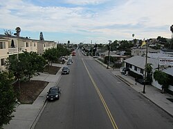
Looking south into Grant Hill from Market and 30th Streets
Nickname(s): 
"GHP"
SanDiegoCentral.gif
Grant Hill is located in the central portion of the city of San Diego and part of the Southeastern Planning Area.
Location map Southern San Diego.png
Red pog.svg
Grant Hill, San Diego
Location within San Diego
Coordinates: 32°42′33″N117°08′02″W / 32.7093°N 117.1338°W / 32.7093; -117.1338
Country Flag of the United States.svg  United States of America
State Flag of California.svg  California
County Flag of San Diego County, California.png San Diego
City Flag of San Diego, California.svg San Diego
ZIP Code
92102

Grant Hill is an urban neighborhood in central San Diego, California bordered by Golden Hill to the north, Stockton to the east, Sherman Heights to the west, and Logan Heights to the south. [1] 30th Street connects Grant Hill to the neighborhood of Golden Hill. Grant Hill is part of the Southeastern Planning Area. [2]

Related Research Articles

<span class="mw-page-title-main">Logan Heights, San Diego</span> Community of San Diego in California

Logan Heights is an urban neighborhood in central San Diego, California. It is bordered by Interstate 5 on the south and west, Interstate 15 on the east, and Imperial Avenue on the north. It is part of the Southeastern Planning Area.

Barrio Logan, San Diego Community of San Diego in California

Barrio Logan is a neighborhood in south central San Diego, California. It is bordered by the neighborhoods of East Village and Logan Heights to the north, Shelltown and Southcrest to the east, San Diego Bay to the southwest, and National City to the southeast. Interstate 5 forms the northeastern boundary. The Barrio Logan Community Plan Area comprises approximately 1,000 acres, of which slightly more than half is under the jurisdiction of the Port of San Diego or the United States Navy rather than the city of San Diego. The community is subject to the California Coastal Act. Though located near the City's Central core, it has long been considered part of Southeast San Diego by many locals, being directly Southeast of Downtown, and with previous historical records labeling it as part of "Western Southeast San Diego."

Golden Hill, San Diego Neighborhood in San Diego, California

Golden Hill is a neighborhood of San Diego, California. It is located south of Balboa Park, north of Sherman Heights/Highway 94, and east of Downtown.

<span class="mw-page-title-main">Paradise Hills, San Diego</span> Community of San Diego in California

Paradise Hills is an urban neighborhood in the southeastern area of the city of San Diego, California. It is an outlying neighborhood adjacent to the independent city of National City and the unincorporated communities of Lincoln Acres and certain portions of Bonita. The neighborhood is part of the Skyline-Paradise Hills Community Planning Area.

<span class="mw-page-title-main">Torrey Pines, San Diego</span>

Torrey Pines is a community of 2,600 acres (1,100 ha) in the northern coastal area of San Diego, California, residential with large areas of office space along I-5.

El Cerrito is a neighborhood of the Mid-City region of San Diego, California. El Cerrito is a residential neighborhood, consisting mostly of suburban homes, with some commercial activity along the streets that define its borders.

Webster is a neighborhood of the Mid-City region of San Diego, California.

Southeast San Diego Community of San Diego in California

Southeast San Diego refers to the southeastern portion of the City of San Diego and the neighborhoods south of State Route 94 and east of Downtown San Diego. There are three official community planning areas: Skyline-Paradise Hills, Encanto Neighborhoods, and Southeastern.

Del Mar Heights, San Diego

Del Mar Heights is an upscale neighborhood near the coast in San Diego, California bordered by Solana Beach to the north, North City and Carmel Valley to the east, Del Mar to the west, and Torrey Pines to the south. I-5 forms the eastern boundary. It is noted for its hills.

Sherman Heights, San Diego Community of San Diego in California

Sherman Heights is an urban neighborhood in central San Diego bordered by Golden Hill to the north, Grant Hill to the east, East Village to the west, and Logan Heights to the south. It is part of the Southeastern Planning Area.

Stockton, San Diego Community of San Diego in California

Stockton is an urban neighborhood in central San Diego, California bordered by Golden Hill to the north, Mountain View and Mt. Hope to the east, Grant Hill to the west, and Logan Heights to the south. I-15 forms the eastern boundary. It is part of the Southeastern Planning Area.

Alta Vista, San Diego Community of San Diego in California

Alta Vista is a small neighborhood in southeastern San Diego City, California, United States. It is bordered by National City to the west, Bay Terraces to the east, Encanto and Valencia Park to the north.

Mountain View, San Diego Community of San Diego in California

Mountain View is an urban community in the southeastern section of the city of San Diego. It is bordered by Mount Hope and Greenwood Memorial Park on the north, Interstate 15 and the neighborhoods of Stockton and Logan Heights on the west, Interstate 805 and Lincoln Park on the east, and Southcrest and National City on the south. Major thoroughfares include Imperial Avenue and Ocean View Boulevard.

<span class="mw-page-title-main">Southcrest, San Diego</span> Community of San Diego in California

Southcrest is an urban community in the southeastern section of the city of San Diego. It is bordered by Mountain View on the north and east, Interstate 5 and the neighborhoods of Barrio Logan and Logan Heights on the west, and Shelltown on the south. Major thoroughfares include National Avenue and 40th Street.

Valencia Park, San Diego Community of San Diego in California

Valencia Park is an urban community in the southeastern section of the city of San Diego. It is bordered by Emerald Hills and Market Street on the north, Lincoln Park and Euclid Avenue on the west, Encanto on the east, and Alta Vista and National City, California on the south. Major thoroughfares include Imperial Avenue, Churchward Street, and Valencia Parkway.

Broadway Heights, San Diego Community of San Diego in California

Broadway Heights is a small community in the southeastern section of the city of San Diego. It is bordered on the north, east, and west by Lemon Grove, and on the south by Encanto and Mallard Street. The predominantly African-American community has 629 residents within its seven blocks. Weston Street was renamed to Martin Luther King Jr. Way due to a youth campaign, marking the first time a street in San Diego was named after him.

Fairmount Park is a neighborhood of San Diego, California. Its borders are defined by Interstate 15 to the west, Interstate 805 to the east and California Highway 94 to the south. Its neighboring communities are South Park and Golden Hill to the west, Azalea Park and City Heights to the east, and Webster to the south. It is primarily residential, mostly single-family homes, with a small commercial area along Home Avenue including several restaurants and convenience stores. Bayridge is a small neighborhood within Fairmount Park on its westernmost knoll, identifiable by its outstanding views and well-maintained townhouse development. Fairmount Park is 3 miles from Downtown San Diego. Chollas Creek runs through it.

Memorial, San Diego Community of San Diego in California

Memorial is an urban neighborhood in the southeastern area of San Diego, California. It is generally bounded by Imperial Avenue to the north, California State Route 15 to the east, Interstate 5 to the south, and 28th Street to the west. Major thoroughfares in the neighborhood include Commercial Street, Oceanview Boulevard, and National Avenue. The San Diego Trolley runs through the area. Chollas Creek flows through the eastern edge of the neighborhood.

Lomita, San Diego Community of San Diego in California

Lomita, also known as Lomita Village, is an urban neighborhood in the southeastern area of San Diego, California. It is bounded by Meadowbrook Drive and Skyline West to the west, unincorporated La Presa to the east and Skyline East to the south, and Jamacha to the north. Major thoroughfares in the neighborhood include San Vicente Street and Worthington Avenue. The neighborhood is part of the Skyline-Paradise Hills Community Planning Area.

Jamacha, San Diego Community of San Diego in California

Jamacha is a neighborhood in the southeastern area of San Diego, California. It is generally bounded by the city of Lemon Grove to the north, unincorporated La Presa to the east, Imperial Avenue and Encanto to the west, and Skyline and Lomita Village to the south. Major thoroughfares include Lisbon Street, Jamacha Road, and Woodrow Avenue. The neighborhood is part of the Skyline-Paradise Hills Community Planning Area.

References

  1. "Central Neighborhood | Neighborhood Maps". Archived from the original on 2009-11-06. Retrieved 2009-09-14.
  2. "Community Profiles: Southeastern San Diego". City of San Diego. Retrieved 2020-11-22.

Coordinates: 32°42′33″N117°08′02″W / 32.7093°N 117.1338°W / 32.7093; -117.1338