Carmel Mountain Ranch, San Diego

Last updated
Carmel Mountain Ranch, San Diego
Carmel Mountain Ranch
SanDiegoMapCarmelMtn.jpg
Carmel Mountain Ranch and neighborhood boundaries
Location map Northeastern San Diego.png
Red pog.svg
Carmel Mountain Ranch, San Diego
Location within Northeastern San Diego
San Diego County California Incorporated and Unincorporated areas.svg
Red pog.svg
Carmel Mountain Ranch, San Diego
Carmel Mountain Ranch, San Diego (San Diego County, California)
Coordinates: 32°58′40.27″N117°4′45.26″W / 32.9778528°N 117.0792389°W / 32.9778528; -117.0792389 Coordinates: 32°58′40.27″N117°4′45.26″W / 32.9778528°N 117.0792389°W / 32.9778528; -117.0792389
Country Flag of the United States.svg  United States of America
State Flag of California.svg  California
County Flag of San Diego County, California.png San Diego
City Flag of San Diego, California.svg San Diego

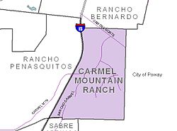
Carmel Mountain Ranch, sometimes shortened to simply Carmel Mountain, or abbreviated to CMR by local residents and organizations is a community of San Diego, California, United States, in the northeastern part of the city. Despite its name, Carmel Mountain Ranch is actually in the shadow of Black Mountain. Carmel Mountain proper is about 10 miles west of the Carmel Mountain Ranch neighborhood.

Contents

Geography

The community is bounded by the city of Poway to the east, and other communities of San Diego on all other sides: Rancho Bernardo to the north, Rancho Peñasquitos to the west, and Sabre Springs to the south. [1]

Economy

At Home (formerly Kmart, later Sears Essentials), Petco, and Best Buy are among the biggest retailers in this shopping center; however, there are dozens of others, and a directory can be viewed on the referenced website below. It is the largest in terms of area of the centers. Carmel Mountain Plaza.jpg
At Home (formerly Kmart, later Sears Essentials), Petco, and Best Buy are among the biggest retailers in this shopping center; however, there are dozens of others, and a directory can be viewed on the referenced website below. It is the largest in terms of area of the centers.

Retail

Several shopping centers are located adjacent to one another:

Commercial

The Carmel Mountain Ranch/Rancho Bernardo submarket is the fifth-largest office space submarket in San Diego County, with over 6 million square feet of office space. [4] It is part of an "I-15 edge city", edge city being a major center of employment outside a traditional downtown. [5]

The Carvin Corporation is headquartered near these centers. [6] [7] The Carmel Mountain Ranch Country Club is a closed golf course located in the community.

In 1993, the United States Postal Service opened the Margaret L. Sellers Processing and Distribution Center. [8] The facility is over 15 acres and employees over 1,500 people. [9] Sorting mail destined as far north as Fallbrook, and as far east as Tecate, during the holiday season the facility processes over 300 million items. [10] It replaced the Midway Processing and Distribution Facility, in the Midway neighborhood, which opened in 1972 and stopped processing regional mail in 1993; [11] that facility was built on the site of the Dutch Flats Airport, once utilized by Charles Lindbergh prior to his transatlantic flight. [12]

Transportation

A Ralphs grocery store, banks, and retail shops are located here. Carmel Mountain Ranch Town Center.jpg
A Ralphs grocery store, banks, and retail shops are located here.

Thoroughfares

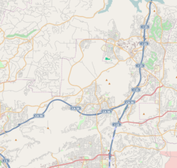
I-15 runs along the western edge of Carmel Mountain, and a noticeable stone marker, complete with sign and flags, is visible from the northbound lanes to act as a gateway immediately before the Carmel Mountain Road exit, which is the primary road serving the community. [13] The eastern terminus of SR 56 becomes Ted Williams Parkway as it enters the community; however, it retains its freeway characteristics until it crosses Rancho Carmel Drive. Transportation access from the eastern end of State Route 56, the Ted Williams Parkway and I-15 express lane exits make this community attractive to area commuters. [14]

Public

There are local bus routes. [15] While Carmel Mountain does not share in the name, the Sabre Springs / Penasquitos Transit Station, which provides direct access to the managed express lanes on I-15, is adjacent to the community. [16]

Community events

Costco Wholesale is the main anchor here; however, there are also smaller stores, such as eateries and a bank. Carmel Mountain Price Plaza.jpg
Costco Wholesale is the main anchor here; however, there are also smaller stores, such as eateries and a bank.

Every year the local Chamber of Commerce, headquartered within the community, [17] hosts a fall festival at which local businesses, community organizations, and school representatives set up information booths and interact with attendees.

Fairway Village, a neighborhood division of Carmel Mountain Ranch running east-to-west on Stoney Gate Place, parallel to Ted Williams Parkway and crossed by Shoal Creek Drive, presents an annual Christmas light show called "Holiday Magic at Fairway Village." [18] The neighborhood lights more than 85 homes from December 1 to January 1. Each year on the Saturday before Christmas, the neighborhood holds an evening block party that is open to the public, where visitors can walk through the neighborhood, enjoy the lights and festivities, and partake of snacks and hot drinks offered by many homes. This event has been featured in several San Diego Family magazine articles. [19] [20] The neighborhood is also very popular at Halloween due to it being a large cul-de-sac street with no hills. [21]

Parks and recreation

Carmel Mountain Ranch Community Park is located just north of Ted Williams Parkway on Rancho Carmel Drive, just east of the 15. Highland Ranch Park is located north of Eastbourne Road and slightly northeast of Highland Ranch Road.

The former Carmel Mountain Ranch golf course sprawls much of the community and has closed its failed business.

Schools

The Home Depot is the anchor of this center; however, there are multiple restaurants and smaller shops as well. Carmel Mountain Ranch Home Center.jpg
The Home Depot is the anchor of this center; however, there are multiple restaurants and smaller shops as well.

Carmel Mountain Ranch is served by the Poway Unified School District. [22]

High schools

Middle school students at Carmel Mountain Ranch's three middle schools feed into Mt. Carmel High School, Poway High School, or Rancho Bernardo High School. [23]

Middle schools

Elementary students feed into Bernardo Heights Middle School in Rancho Bernardo, Meadowbrook Middle School, [24] or Black Mountain Middle School [25] in Rancho Peñasquitos. [23]

Elementary schools

Sports

There is a baseball league for kindergarten - 8th grade. There are also a youth basketball league and other recreational sports. [30]

Related Research Articles

<span class="mw-page-title-main">Poway, California</span> City in the state of California, United States

Poway is a city in San Diego County, California, United States. The unincorporated community became a city on December 1, 1980. Poway's rural roots influenced its motto "The City in the Country". The city has a population of 49,701 as of 2019.

<span class="mw-page-title-main">North County (San Diego area)</span> Region of the San Diego Metro Area in California

North County is a region in the northern area of San Diego County, California. It is the second-most populous region in the county, with an estimated population of 869,322. North County is well known for its affluence, especially in Encinitas, Carlsbad, Del Mar, Rancho Santa Fe, and Solana Beach, where house prices range, on average, above $1,000,000. Cities along the 78 freeway have more mixed incomes.

<span class="mw-page-title-main">California State Route 56</span> East–west state highway in the U.S. state of California

State Route 56 (SR 56) is an east–west state highway in the U.S. state of California. It runs 9.210 miles (14.822 km) from Interstate 5 (I-5) in the Carmel Valley neighborhood of San Diego to I-15. The eastern terminus of the highway is also the western end of the Ted Williams Parkway. SR 56 serves as an important connector between I-5 and I-15, being the only east–west freeway between SR 78 in north San Diego County, several miles away, and SR 52 near Marine Corps Air Station Miramar. It is also named the Ted Williams Freeway, after the San Diego-born baseball player.

Mira Mesa is a community and neighborhood in the city of San Diego, California. The city-recognized Mira Mesa Community Plan Area is roughly bounded by Interstate 15 on the east, Interstate 805 on the west, the Los Peñasquitos Canyon on the north and Marine Corps Air Station Miramar on the south. Most of the community plan area is referred to as Mira Mesa; the community plan area also includes the neighborhoods of Sorrento Valley and Sorrento Mesa.

<span class="mw-page-title-main">Area codes 619 and 858</span> Area codes serving San Diego County, California

Area codes 619 and 858 are telephone area codes in the North American Numbering Plan (NANP) for most of San Diego County in the U.S. state of California.

Poway Unified School District is a school district located in Poway, California. The district operates 26 elementary schools, seven middle schools (6–8); five comprehensive high schools (9–12); and one continuation high school. Twenty-one of the district's schools are located in the city of San Diego; eleven others are in the city of Poway. The district serves approximately 33,000 students in San Diego County and is the third-largest school district in the county.

<span class="mw-page-title-main">California's 48th congressional district</span> U.S. House district for California

California's 48th congressional district is a congressional district in the U.S. state of California based in San Diego County in Southern California. It is currently represented by Republican Darrell Issa.

<span class="mw-page-title-main">Carmel Valley, San Diego</span> Community of San Diego in California

Carmel Valley is a suburban planned community in the northwestern corner of San Diego, California, United States. The community is composed of commercial offices, residential units, hotels, retail stores and restaurants.

<span class="mw-page-title-main">California's 50th congressional district</span> U.S. House district for California

California's 50th congressional district is a congressional district in the U.S. state of California, and encompasses the central and northeastern parts of San Diego County and a small part of Riverside County. Scott Peters is currently the U.S. representative for California's 50th congressional district.

<span class="mw-page-title-main">Rancho Bernardo, San Diego</span> Community of San Diego in California

Rancho Bernardo is a master-planned community in the northern hills of the city of San Diego, California.

<span class="mw-page-title-main">Rancho Peñasquitos, San Diego</span> Community of San Diego in California, United States

Rancho Peñasquitos is a suburban community in the northeastern part of the city of San Diego, California. It is named after the first Mexican land grant in the county, Rancho Santa Maria de Los Peñasquitos. Peñasquitos means "little cliffs" in Spanish. It abuts Los Peñasquitos Canyon Preserve, an open space preserve that offers hiking, biking, and equestrian trails. The community is commonly abbreviated "PQ."

<span class="mw-page-title-main">Black Mountain Ranch, San Diego</span> Community of San Diego in California

Black Mountain Ranch is a suburban community in the northern part of the city of San Diego, California. Black Mountain Ranch encompasses 5,100 acres (21 km2) and is located north of Rancho Peñasquitos and Torrey Highlands, south of the Santa Fe Valley, east of Fairbanks Ranch and Rancho Santa Fe, and west of 4S Ranch.

<span class="mw-page-title-main">4S Ranch, California</span> Unincorporated community in California, United States

4S Ranch is a locale of San Diego County, California. It is located about 25 miles (40 km) north of downtown San Diego and 13 miles (21 km) east of the Pacific Ocean in the North County Inland area of San Diego. To the east of 4S Ranch is the San Diego community of Rancho Bernardo. To the west is the Santa Fe Valley, which includes Rancho Santa Fe. Lake Hodges forms the northern border of the community while Black Mountain Ranch, which includes Del Sur and Santaluz, and Rancho Peñasquitos are both situated to the south. The ZIP Code is 92127, and the community is inside area code 858.

San Pasqual Valley, historically spelt as San Pascual, is the northernmost community of the city of San Diego. It is named for the Kumeyaay village of San Pasqual that was once located there. It is bordered on the north by the city of Escondido, on the east and west by unincorporated land within San Diego County, and on the south by the city of Poway and the community of Rancho Bernardo. San Pasqual Valley is home to the San Diego Zoo Safari Park.

<span class="mw-page-title-main">Sabre Springs, San Diego</span> Community of San Diego in California

Sabre Springs is a community in San Diego, California, located in the northeastern part of the city. It is bounded by the city limits of Poway on the east, Ted Williams Parkway on the north, Interstate 15 on the west, and the community of Miramar Ranch North to the south. Sabre Springs is bisected north-south by Poway Road.

<span class="mw-page-title-main">Torrey Highlands, San Diego</span> Community of San Diego in California

Torrey Highlands is a primarily residential community in northern San Diego, California. Most of the community has been developed from 2000 to present.

<span class="mw-page-title-main">Pacific Highlands Ranch, San Diego</span> Community of San Diego in California

Pacific Highlands Ranch is a primarily residential community of approximately 2,652 acres (1,073 ha) in northern San Diego, California. As part of San Diego City Council District 1, it is represented by Joe LaCava, elected in 2020, and as part of District 3 of the San Diego County Board of Supervisors, it is represented by Terra Lawson-Remer, also elected in 2020. Both had not been elected to those positions before.

Palomar Medical Center Poway is a hospital in Poway, California, operated by Palomar Health. It opened in 1977.

<span class="mw-page-title-main">Fairway Village</span> Community of San Diego in California

Fairway Village is a neighborhood division of Carmel Mountain Ranch, located along Stoney Gate Place, parallel to Ted Williams Parkway and crossed by Shoal Creek Drive, in San Diego, California.

<span class="mw-page-title-main">2020 San Diego elections</span>

Municipal elections were held in San Diego in 2020 for mayor, city attorney, and city council. The primary election occurred Tuesday, March 3, 2020, and the general election occurred Tuesday, November 3, 2020. Five of the nine council seats were contested. No council incumbents stood for reelection.

References

  1. "Carmel Mountain Ranch | Councilmember Marni von Wilpert (District 5) | City of San Diego Official Website". www.sandiego.gov. Retrieved 2021-05-07.
  2. http://www.carmelmountainplaza.com/
  3. http://shop-carmel-mountain-ranch.com/
  4. ""San Diego submarkets Q1 2019", Avison Young". Archived from the original on 2019-07-02. Retrieved 2019-07-02.
  5. Garreau, Joel (1991). Edge City. p. 436. ISBN   9780385424349 . Retrieved July 1, 2019.
  6. "Carvin Corp - Company Profile and News". Bloomberg.com. Retrieved 2021-05-07.
  7. "Kiesel Guitars Contact Us".
  8. unestidstwern (22 February 2007). "All roads lead to CMR regional mail center". Pomerado News. Poway. Retrieved 14 July 2018 via San Diego Union-Tribune.
  9. Bouvier, Geoff (1 February 2007). "Where the Mail Goes When it Doesn't Get to You". San Diego Reader. Retrieved 14 July 2018.
  10. Himchak, Elizabeth Marie (13 December 2017). "Postal Service is in the midst of 'busiest' time". Pomerado News. Poway. Retrieved 14 July 2018 via San Diego Union Tribune.
  11. Hall, Matthew T. (23 February 2012). "USPS Midway processing plant set to close". San Diego Union-Tribune. Retrieved 14 July 2018.
  12. Schwab, Dave (29 January 2014). "Mammoth Midway postal facility back on sales block". San Diego Community News Group. Retrieved 14 July 2018.
    Freeman, Paul (11 October 2016). "Abandoned & Little-Known Airfields: California: Northern San Diego area". California Pilots Association. Retrieved 14 July 2018.
    Monteagudo, Merrie (2018). "Never-before published photos of Charles Lindbergh test flying the Spirit of St. Louis". Hoy San Diego. Retrieved 14 July 2018 via San Diego Union Tribune.
  13. https://maps.google.com/maps?f=q&source=s_q&hl=en&geocode=&q=Carmel+Mountain,+San+Diego,+CA&sll=37.0625,-95.677068&sspn=33.764224,60.029297&ie=UTF8&hq=&hnear=Carmel+Mountain,+San+Diego,+California&ll=32.97184,-117.090461&spn=0.008731,0.014656&t=h&z=16&layer=c&cbll=32.972053,-117.090346&panoid=YDwxSRffHyVgXt9kATZjmw&cbp=12,72.85,,1,2.69 Street View of the gateway marker
  14. "Community Profiles: Carmel Mountain Ranch | Planning Department | City of San Diego Official Website". www.sandiego.gov. Retrieved 2020-03-16.
  15. bus routes through Carmel Mountain Ranch
  16. "Service Notices". 22 May 2015.
  17. "San Diego North Chamber of Commerce". Archived from the original on 2010-01-30. Retrieved 2010-01-29.
  18. "Christmas – Fairway Village News".
  19. "San Diego Family magazine". Archived from the original on 2012-02-18. Retrieved 2012-02-17.
  20. "2012 Map of Christmas Lights". Archived from the original on 2013-04-25. Retrieved 2012-02-17.
  21. "Halloween – Fairway Village News".
  22. http://www.powayusd.com/schools/
  23. 1 2 "Feeder Schools Report" (PDF). Archived (PDF) from the original on November 19, 2020.
  24. "Poway Unified - Meadowbrook Middle School (MBMS)".
  25. http://www.powayusd.com/pusdbmms/
  26. "Poway Unified - Highland Ranch Elementary".
  27. https://www.powayusd.com/en-US/Schools/ES/SCES/Home
  28. https://www.powayusd.com/en-US/Schools/ES/CSES/Home
  29. https://www.powayusd.com/en-US/Schools/ES/MCES/Home
  30. http://cmrll.org