Broadway Heights, San Diego

Last updated
Broadway Heights, San Diego
Broadway Heights
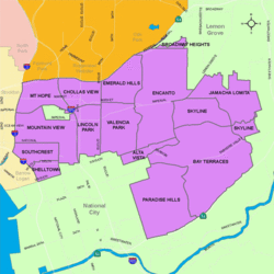
SanDiegoSoutheastMap.gif
Broadway Heights is located in the southeastern area of the city of San Diego
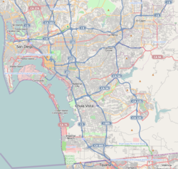
Location map Southern San Diego.png
Red pog.svg
Broadway Heights, San Diego
Location within San Diego
Coordinates: 32°43′54″N117°03′08″W / 32.7316°N 117.0522°W / 32.7316; -117.0522
Country Flag of the United States.svg  United States of America
State Flag of California.svg  California
County Flag of San Diego County, California.png San Diego
City Flag of San Diego, California.svg San Diego
ZIP Code
92114

Broadway Heights is a small community in the southeastern section of the city of San Diego, California, United States. It is bordered on the north, east, and west by Lemon Grove, and on the south by Encanto and Mallard Street. The predominantly African-American community has 629 residents within its seven blocks. [1] Weston Street was renamed to Martin Luther King Jr. Way (after the civil rights leader Martin Luther King Jr.) due to a youth campaign, marking the first time a street in San Diego was named after him.

Contents

History

The Broadway Heights subdivision was approved in the 1950s. Most of the homes were built around 1960. [2] In November 2010, Weston Street was renamed to Martin Luther King Jr. Way. [3] This is the first street in San Diego that was named after Martin Luther King Jr., though a street was once named after him but overturned by voters. [3] The change occurred as a result of members of the Broadway Heights Community Youth Council earlier in the year, in addition to planned improvements for their neighborhood. [3] The children went about getting the street name changed after a campaign of signature gathering, letter writing, and visits to City Hall. [3] The book "Community Resilience to Sectarian Violence in Baghdad" cites Broadway Heights as an example of a minority community in the San Diego area that keeps violence in its community down by addressing it head on. [4] As of the publishing of the book, the murder rate for Broadway Heights was at 0%. [4] Broadway Heights has a program called the Broadway Heights Community Council's Intergenerational Tour, wherein youth members participate in a leadership development program to receive mentorship, tutoring, and leadership skills training from the seniors of the community. This program was cited as an example of a successful intergenerational program by the book "Kraus' Recreation and Leisure in Modern Society". [5]

Education

Broadway Heights is served by San Diego Unified School District.

Related Research Articles

<span class="mw-page-title-main">University Heights, Newark</span> Populated place in Essex County, New Jersey, US

University Heights is a neighborhood in Newark in Essex County, in the U.S. state of New Jersey. It is so named because of the four academic institutions located within its boundaries: Rutgers University, New Jersey Institute of Technology (NJIT), New Jersey Medical School (Rutgers) and Essex County College. In total, the schools enroll approximately 30,000 degree-seeking students.

<span class="mw-page-title-main">Mount Hope, San Diego</span> Community of San Diego in California

Mount Hope is an ethnically diverse, hilly urban neighborhood in San Diego, California. Located in the southeastern portion of the city, Mount Hope is named for the large municipal Mount Hope Cemetery, which encompasses approximately 115 acres (0.47 km2) of the community. The neighborhood contains a mixture of residential, industrial, commercial, and cemetery uses.

City Heights is a dense urban community in central San Diego, California, known for its ethnic diversity. The area was previously known as East San Diego. City Heights is located south of Mission Valley and northeast of Balboa Park.

<span class="mw-page-title-main">Golden Hill, San Diego</span> Neighborhood in San Diego, California

Golden Hill is a neighborhood in San Diego, California. It is located south of Balboa Park, north of Sherman Heights, Grant Hill and Stockton, and east of downtown.

The Encampment for Citizenship (EFC) is a non-profit, non-partisan, non-sectarian organization currently based in California that conducts a residential summer programs with year-round follow-up for young people of widely diverse backgrounds and nations. The Encampment program brings youth together to form a self-governing community, learn to think critically about pressing social and political issues, and become empowered to take action. The EFC was founded in 1946 by Algernon D. Black, a leader of the New York Society for Ethical Culture, and Alice K. Pollitzer, a prominent civic leader. The program was sponsored by the American Ethical Union and its affiliated societies, in particular the New York Ethical Culture Society.

<span class="mw-page-title-main">Downtown San Diego</span> City center of San Diego, California, United States

Downtown San Diego is the central business district of San Diego, California, the eighth largest city in the United States. It houses the major local headquarters of the city, county, state, and federal governments. The area comprises seven districts: Gaslamp Quarter, East Village, Columbia, Marina, Cortez Hill, Little Italy, and Core.

<span class="mw-page-title-main">King Center for Nonviolent Social Change</span> Not-for-profit organization in Atlanta, Georgia, United States

The Martin Luther King Jr. Center for Nonviolent Social Change, commonly known as The King Center, is a nongovernmental, not-for-profit organization in Atlanta, United States.

Ghost Town is the informal name of the Hoover-Foster Historic District neighborhood in West Oakland, Oakland, California.

<span class="mw-page-title-main">Southeast San Diego</span> Community of San Diego in California

Southeast San Diego refers to the southeastern portion of San Diego, including the neighborhoods south of State Route 94 and east of downtown San Diego. Southeast San Diego has no official definition, but it may be considered coterminous with three official planning areas: Skyline-Paradise Hills, Chollas Valley, and Southeastern.

The 1967 Buffalo riot was one of 159 race riots that swept cities in the United States during the "Long Hot Summer of 1967". This riot occurred on the East Side of Buffalo, New York from June 26 to July 1, 1967. On the afternoon of June 27, 1967, small groups of African American teenagers cruised the neighborhood of William Street and Jefferson Avenue breaking car and store windows. By night, nearly 200 riot-protected police were summoned and a violent encounter ensued.

<i>Landmark for Peace Memorial</i> Memorial sculpture in Indianapolis, Indiana, U.S.

The Landmark for Peace is a memorial sculpture in Dr. Martin Luther King Jr. Park on the northside of Indianapolis. It honors the contributions of the slain leaders Robert F. Kennedy and Martin Luther King Jr. The memorial, which features Kennedy and King reaching out to each other, was designed and executed by Indiana artist Greg Perry. The bronze portraits were created by Indianapolis sculptor Daniel Edwards.

<span class="mw-page-title-main">St. Augustine movement</span> Part of the wider Civil Rights Movement in St. Augustine, Florida

The St. Augustine movement was a part of the wider Civil Rights Movement, taking place in St. Augustine, Florida from 1963 to 1964. It was a major event in the city's long history and had a role in the passage of the Civil Rights Act of 1964.

<span class="mw-page-title-main">Azalea Park, San Diego</span>

Azalea Park is a community in City Heights in the greater San Diego, California, area. It is located on top of a plateau 3 miles east of San Diego Bay, with an elevation of around 300 feet. It is bordered to the north by Manzanita Canyon Fairmount Avenue to the east, Interstate 805 to the west, and Hollywood Park to the south.

<span class="mw-page-title-main">Sherman Heights, San Diego</span> Community of San Diego in California

Sherman Heights is an urban neighborhood in central San Diego, California, bordered by Golden Hill to the north, Grant Hill to the east, East Village to the west, and Logan Heights to the south. It is part of the Southeastern Planning Area.

Joseph Earl Marshall, Jr. is an American author, lecturer, radio talk show host, and community activist.

<span class="mw-page-title-main">King assassination riots</span> Riots following the assassination of Martin Luther King Jr.

The King assassination riots, also known as the Holy Week Uprising, were a wave of civil disturbance which swept across the United States following the assassination of Martin Luther King Jr. on April 4, 1968. Some of the biggest riots took place in Washington, D.C., Baltimore, Chicago, and Kansas City.

<span class="mw-page-title-main">Memorial, San Diego</span> Neighborhood in California, United States

Memorial is an urban neighborhood in the southeastern area of San Diego, California. It is generally bounded by Imperial Avenue to the north, California State Route 15 to the east, Interstate 5 to the south, and 28th Street to the west. Major thoroughfares in the neighborhood include Commercial Street, Oceanview Boulevard, and National Avenue. The San Diego Trolley runs through the area. Chollas Creek flows through the eastern edge of the neighborhood.

Kyle Holbrook is an American muralist and activist best known for his street art in Pittsburgh, Pennsylvania and Miami, Florida.

The Soaring Eagles Dance Group is an organization that teaches American Indian students from grades K-12 to powwow dance. The children put on exhibitions of cultural dance while wearing tribal regalia for audiences across Southern California. The aim of the program is to preserve traditions and culture through education of Native American youth.

References

  1. Cadelago, Christopher; Hall, Matthew T. (2011-01-15). "Community spirit defines tiny Broadway Heights" . Retrieved 2015-04-25.
  2. "Southeastern San Diego Community Plan" (PDF). City of San Diego * Planning Department. Retrieved 2015-04-25.
  3. 1 2 3 4 Florido, Adrian (2010-11-09). "A Change Has Come to Broadway Heights". Voice of San Diego. Retrieved 2015-04-25.
  4. 1 2 Carpenter, Ami C. (2013-10-04). Community Resilience to Sectarian Violence in Baghdad. Springer Science & Business Media. p. 114. ISBN   9781461488125 . Retrieved 2015-04-25.
  5. McLean, Daniel; Dayer-Berenson, Linda; Seaward, Brian Luke; Hurd, Amy (2014-02-20). Kraus' Recreation and Leisure in Modern Society. Jones & Bartlett Publishers. ISBN   9781449689575 . Retrieved 2015-04-25.

32°43′52″N117°3′7″W / 32.73111°N 117.05194°W / 32.73111; -117.05194