Emerald Hills, San Diego

Last updated
Emerald Hills, San Diego
Emerald Hills
Emerald Hills, San Diego, California (15035667184).jpg
2014 aerial photo of Emerald Hills
SanDiegoSoutheastMap.gif
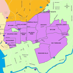
Emerald Hills is located in the southeastern area of the city of San Diego
Location map Southern San Diego.png
Red pog.svg
Emerald Hills, San Diego
Location within San Diego
Coordinates: 32°42′58″N117°04′35″W / 32.7162°N 117.0765°W / 32.7162; -117.0765
Country Flag of the United States.svg  United States of America
State Flag of California.svg  California
County Flag of San Diego County, California.png San Diego
City Flag of San Diego, California.svg San Diego
ZIP Code
92114

Emerald Hills is a neighborhood in the southeastern section of the city of San Diego, California, United States. It is bordered by Oak Park and California State Route 94 on the north, Chollas View and Euclid Avenue on the west, Encanto and Skyline Drive on the east, and Valencia Park and Market Street on the south. Major thoroughfares include Kelton Road and Roswell Street.

Contents

History

The area which constitutes Emerald Hills was once a burial site for the local Kumeyaay Indian tribe. The modern neighborhood is named for the Emerald Hills Country Club and Golf Course, established in the area in 1929. The club was sold in 1939 to Thomas Sharp (of Sharp Health Care) to build a transmitter site for his radio stations KFSD-AM/FM. Due to the proximity to the Chollas Naval Towers, the KFSD towers were not built until 1948. During the war Sharp continued to operate the golf course, and after the radio transmitter facility was built, Emerald Hills was lowered from an 18 hole course to a 9 hole. Sharp sold the remaining golf course to developers to be used for homes in 1958. [1]

Landmarks and facilities

The highest point in Emerald Hills holds a radio transmitter for AM 600 KOGO.The transmitter site predates the community as it was built in 1948 for AM 600 KFSD, now KOGO. [2]

Much of Emerald Hills is open space, including Radio Canyon. A portion of Chollas Creek flows through the neighborhood.

The Malcolm X Library and Performing Arts Center is located at 5148 Market Street.

Christian Fellowship Congregational Church (UCC) is located at 1601 Kelton Road (site of the Emerald Hills Golf Clubhouse).

Education

Emerald Hills is served by the San Diego Unified School District. Public schools in Emerald Hills include Johnson Magnet School.

See also

Related Research Articles

<span class="mw-page-title-main">KGTV</span> ABC affiliate in San Diego

KGTV is a television station in San Diego, California, United States, affiliated with ABC and owned by the E. W. Scripps Company. The station's studios are located on Air Way in the Riverview-Webster section of San Diego, and its transmitter is located on Mount Soledad in La Jolla.

KGB-FM is a commercial radio station licensed to San Diego, California. It is owned and operated by iHeartMedia and broadcasts a classic rock music format. KGB-FM's studios are located in San Diego's Kearny Mesa neighborhood on the northeast side, and the transmitter is located in East San Diego east of Balboa Park.

KOGO is a commercial AM radio station in San Diego, California. The station airs a news/talk radio format and is owned by iHeartMedia, Inc. The station's studios and offices are located in San Diego's Kearny Mesa neighborhood on the northeast side.

<span class="mw-page-title-main">KCBQ</span> Talk radio station in San Diego

KCBQ is a commercial AM radio station in San Diego, California. It is owned by Salem Media Group and airs a talk radio format. Studios and offices are on Towne Center Drive in San Diego's University City area. The transmitter is off Moreno Avenue in Lakeside, California. By day, KCBQ operates at 50,000 watts, the maximum power for American AM stations. Because KCBQ is not a clear-channel station, it must reduce its power at night to 2900 watts to avoid interfering with Class A stations KTSB in Tulsa, Oklahoma and WWVA in Wheeling, West Virginia, both clear-channel stations. KCBQ uses a directional antenna at all times.

KFSD is a radio station based in North County, San Diego, California. It is owned by Raul Caro and Stephen Beuerle, through licensee IHS Media, and is currently off the air. The station's studios are located in Carlsbad, while the transmitter is located in an industrial park in Escondido.

KGTV Tower is a 235-meter-high (771 ft) self-support Ideco Dresser television tower in La Jolla, California, United States.

KSPA is a commercial radio station located in Ontario, California, broadcasting to the Inland Empire area. KSPA last aired a Vietnamese-language format. KSPA was the flagship station of the Rancho Cucamonga Quakes of the California League of Minor League Baseball from 2008 to 2013. It is also an affiliate of the San Diego Chargers and USC Trojans football. Until 2008, KSPA was a local affiliate of the Los Angeles Angels of Anaheim.

<span class="mw-page-title-main">Clairemont, San Diego</span> Community of San Diego in California

Clairemont is a community within the city of San Diego, California, United States. It has a population of about 81,600 residents and an area of roughly 13.3 square miles (34 km2). Clairemont Mesa is bordered by Interstate 805 on the east, Interstate 5 to the west, State Route 52 to the north, and the community of Linda Vista to the south. The community of Clairemont Mesa can be subdivided into the neighborhoods of North Clairemont, Clairemont Mesa East, Clairemont Mesa West, Bay Park, and Bay Ho.

<span class="mw-page-title-main">Encanto, San Diego</span> Community of San Diego in California

Encanto is a hilly urban neighborhood located in the southeastern region of San Diego, California. The neighborhood is bordered by California State Route 94 and the communities of Oak Park and Broadway Heights to the north, O'Farrell to the south, Emerald Hills and Valencia Park to the west and the City of Lemon Grove to the east.

El Cerrito is a neighborhood of the Mid-City region of San Diego, California. El Cerrito is a residential neighborhood, consisting mostly of suburban homes, with some commercial activity along the streets that define its borders.

<span class="mw-page-title-main">Oak Park, San Diego</span> Community of San Diego in California

Oak Park is an urban neighborhood of the Southeast region of San Diego, California.

<span class="mw-page-title-main">Southeast San Diego</span> Community of San Diego in California

Southeast San Diego refers to the southeastern portion of the City of San Diego and the neighborhoods south of State Route 94 and east of Downtown San Diego. There are three official community planning areas: Skyline-Paradise Hills, Encanto Neighborhoods, and Southeastern.

<span class="mw-page-title-main">Grant Hill, San Diego</span> Community of San Diego in California

Grant Hill is an urban neighborhood in central San Diego, California bordered by Golden Hill to the north, Stockton to the east, Sherman Heights to the west, and Logan Heights to the south. 30th Street connects Grant Hill to the neighborhood of Golden Hill. Grant Hill is part of the Southeastern Planning Area.

<span class="mw-page-title-main">Sherman Heights, San Diego</span> Community of San Diego in California

Sherman Heights is an urban neighborhood in central San Diego bordered by Golden Hill to the north, Grant Hill to the east, East Village to the west, and Logan Heights to the south. It is part of the Southeastern Planning Area.

<span class="mw-page-title-main">Shelltown, San Diego</span> Community of San Diego in California

Shelltown is a neighborhood located within Southeast San Diego, approximately 5 minutes from downtown San Diego by car and 25 minutes by bicycle. It is bordered by National City on the south, Interstate 5 and Barrio Logan on the west, 43rd Avenue on the east, and Gamma Court and the neighborhood of Southcrest on the north. Prior to the 1980s the northern border of Shelltown was National Ave and many residents still consider that the northern border.

<span class="mw-page-title-main">Southcrest, San Diego</span> Community of San Diego in California

Southcrest is an urban community in the southeastern section of the city of San Diego. It is bordered by Mountain View on the north and east, Interstate 5 and the neighborhoods of Barrio Logan and Logan Heights on the west, and Shelltown on the south. Major thoroughfares include National Avenue and 40th Street.

<span class="mw-page-title-main">Chollas View, San Diego</span> Neighborhood in San Diego, California

Chollas View is an urban community in the southeastern section of the city of San Diego. It is bordered by Webster and California State Route 94 on the north, Mount Hope and Interstate 805 on the west, Emerald Hills and Euclid Avenue on the east, and Lincoln Park and the San Diego Trolley on the south. Major thoroughfares include Market Street and 47th Street.

<span class="mw-page-title-main">Valencia Park, San Diego</span> Community of San Diego in California

Valencia Park is an urban community in the southeastern section of the city of San Diego. It is bordered by Emerald Hills and Market Street on the north, Lincoln Park and Euclid Avenue on the west, Encanto on the east, and Alta Vista and National City, California on the south. Major thoroughfares include Imperial Avenue, Churchward Street, and Valencia Parkway.

Fairmount Park is a neighborhood of San Diego, California. Its borders are defined by Interstate 15 to the west, Interstate 805 to the east and California Highway 94 to the south. Its neighboring communities are South Park and Golden Hill to the west, Azalea Park and City Heights to the east, and Webster to the south. It is primarily residential, mostly single-family homes, with a small commercial area along Home Avenue including several restaurants and convenience stores. Bayridge is a small neighborhood within Fairmount Park on its westernmost knoll, identifiable by its outstanding views and well-maintained townhouse development. Fairmount Park is 3 miles from Downtown San Diego. Chollas Creek runs through it.

<span class="mw-page-title-main">Memorial, San Diego</span> Community of San Diego in California

Memorial is an urban neighborhood in the southeastern area of San Diego, California. It is generally bounded by Imperial Avenue to the north, California State Route 15 to the east, Interstate 5 to the south, and 28th Street to the west. Major thoroughfares in the neighborhood include Commercial Street, Oceanview Boulevard, and National Avenue. The San Diego Trolley runs through the area. Chollas Creek flows through the eastern edge of the neighborhood.

References

  1. "Emerald Hills". San Diego. Retrieved 21 July 2014.
  2. "Southeastern San Diego Community Plan" (PDF). San Diego. Retrieved 21 July 2014.

Coordinates: 32°42′58″N117°04′35″W / 32.7162°N 117.0765°W / 32.7162; -117.0765