Oak Park, San Diego

Last updated

Oak Park, San Diego
Oak Park
Aerial - Oak Park, San Diego, CA 01.jpg
2015 aerial photo of Oak Park
SanDiegoSoutheastMap.gif
Oak Park is located in the southeastern area of the city of San Diego
Location map Southern San Diego.png
Red pog.svg
Oak Park, San Diego
Location within San Diego
Coordinates: 32°44′09″N117°04′47″W / 32.7359°N 117.0797°W / 32.7359; -117.0797
Country Flag of the United States.svg  United States of America
State Flag of California.svg  California
County Flag of San Diego County, California.png San Diego
City Flag of San Diego, California.svg San Diego
ZIP Code
92105

Oak Park is an urban neighborhood in the Southeast region of San Diego, California.

Contents

Geography

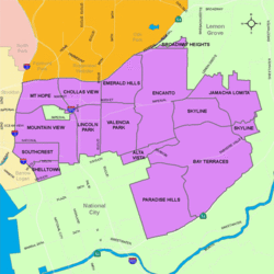
The neighborhood's borders are defined by Euclid Avenue to the west, Chollas Parkway/Streamview Drive/College Avenue to the north, and State Route 94 to the southeast.

Demographics

University Avenue Baptist Church University Avenue Baptist Church.jpg
University Avenue Baptist Church

Oak Park is home to one of the higher concentrations of African-Americans in the city. As of November 2020, demographics for the neighborhood are as follows: people of Hispanic/Latino heritage make up 31.2%, followed by Asians at 25.8%, then African-Americans at 22.0%, non-Hispanic Whites at 16.5%, Mixed Race at 3.7%, and others at 0.8%. [1]

Development

Oak Park is characterized by single family homes, condominiums and apartments, as well as Navy housing.

Oak Park is divided between City Council District 4 and District 7. It has a fire station and a branch of the public library. It's community organization is the Oak Park Community Council. [2]

Chollas Lake 16-acre (65,000 m2) is a lake designated for free youth fishing (age 15 and under); a 0.8 mile dirt path around the lake for walking, jogging, and bicycling; picnic tables with barbecue grills; children's play equipment; a small basketball court; hiking trails; and a multi-purpose ball field in North Chollas canyon.[ citation needed ]

Education

Oak Park hosts two elementary schools.

Economy

Oak Park is located four miles (6 km) from San Diego State University. The community is home to a large mall, the Marketplace at the Grove Shopping Center.

The center originally opened as a traditional shopping mall called College Grove with various national chain retail stores. It was the first shopping center in central San Diego in the Post-War era.

Close to the end of the 1990s, there was a plan to revitalize the dead mall, which included the redevelopment of the mall into strip mall with many big box retailers.

Related Research Articles

<span class="mw-page-title-main">Linda Vista, San Diego</span> Community of San Diego in California

Linda Vista is a community in San Diego, California, United States. Located east of Mission Bay, north of Mission Valley, and south-east of Tecolote Canyon, it lies on a mesa overlooking Mission Valley to the south and Mission Bay and the Pacific Ocean to the west. It is home to the University of San Diego.

<span class="mw-page-title-main">College Area, San Diego</span> Community of San Diego in California

The College Area is a residential community in the Mid-City region of San Diego, California, United States. It is dominated by San Diego State University (SDSU), after which the area is named. Several neighborhoods in the College Area were developed in the 1930s, with others becoming established in the post-war period.

<span class="mw-page-title-main">City Heights, San Diego</span> Community of San Diego in California

City Heights is a dense urban community in central San Diego, California, known for its ethnic diversity. The area was previously known as East San Diego. City Heights is located south of Mission Valley and northeast of Balboa Park.

<span class="mw-page-title-main">Normal Heights, San Diego</span> Community of San Diego in California

Normal Heights is a neighborhood in the mid-city region of San Diego, California.

<span class="mw-page-title-main">Paradise Hills, San Diego</span> Community of San Diego in California

Paradise Hills is an urban neighborhood in the southeastern area of the city of San Diego, California. It is an outlying neighborhood adjacent to the independent city of National City and the unincorporated communities of Lincoln Acres and certain portions of Bonita. The neighborhood is part of the Skyline-Paradise Hills Community Planning Area.

Allied Gardens is a residential neighborhood in the eastern Navajo community of San Diego, California. It neighbors San Carlos to the east, Del Cerro to the south, the College Area to the southeast and Grantville to the southwest.

<span class="mw-page-title-main">San Carlos, San Diego</span> Community of San Diego in California

San Carlos is a neighborhood in the eastern area of San Diego, California. It borders the neighborhoods of Del Cerro, Tierrasanta, Allied Gardens, the city of La Mesa, and Mission Trails Regional Park. The neighborhood extends to Cowles Mountain at the north.

<span class="mw-page-title-main">Encanto, San Diego</span> Community of San Diego in California

Encanto is a hilly urban neighborhood located in the southeastern region of San Diego, California. The neighborhood is bordered by California State Route 94 and the communities of Oak Park and Broadway Heights to the north, O'Farrell to the south, Emerald Hills and Valencia Park to the west and the city of Lemon Grove to the east.

<span class="mw-page-title-main">El Cerrito, San Diego</span> Town in America

El Cerrito is a neighborhood of the Mid-City region of San Diego, California. El Cerrito is a residential neighborhood, consisting mostly of suburban homes, with some commercial activity along the streets that define its borders.

Redwood Village is a neighborhood of the Mid-City region of San Diego, California. Formerly known as Darnall, on June 7, 2007, residents voted to change the name of the neighborhood to Redwood Village. Redwood Village is a mostly residential neighborhood, with the exception of the area South of University avenue which is home to the University Square Shopping Center.

Webster is a neighborhood of the Mid-City region of San Diego, California. It is predominantly Hispanic though it does have a sizable African-American population.

<span class="mw-page-title-main">Rolando, San Diego</span>

Rolando is a neighborhood of the Mid-City region of San Diego, California. Rolando is mostly residential with the exception of El Cajon Boulevard, which features the Campus Plaza shopping center. Rolando is divided by University Avenue into two sections: Rolando Village to the north, and Rolando Park to the south.

<span class="mw-page-title-main">Southeast San Diego</span> Community of San Diego in California

Southeast San Diego refers to the southeastern portion of San Diego, including the neighborhoods south of State Route 94 and east of downtown San Diego. Southeast San Diego has no official definition, but it may be considered coterminous with three official planning areas: Skyline-Paradise Hills, Chollas Valley, and Southeastern.

<span class="mw-page-title-main">Mountain View, San Diego</span> Community of San Diego in California

Mountain View is an urban community in the southeastern section of San Diego, California. It is bordered by Mount Hope and Greenwood Memorial Park on the north, Interstate 15 and the neighborhoods of Stockton and Logan Heights on the west, Interstate 805 and Lincoln Park on the east, and Southcrest and National City on the south. Major thoroughfares include Imperial Avenue and Ocean View Boulevard.

<span class="mw-page-title-main">Southcrest, San Diego</span> Community of San Diego in California

Southcrest is an urban community in the southeastern section of San Diego, California. It is bordered by Mountain View to the north and east, Interstate 5 and the neighborhoods of Barrio Logan and Logan Heights to the west, and Shelltown to the south. Major thoroughfares include National Avenue and 40th Street.

<span class="mw-page-title-main">Chollas View, San Diego</span> Neighborhood in San Diego, California

Chollas View is an urban community in the southeastern section of San Diego, California. It is bordered by Webster and California State Route 94 on the north, Mount Hope and Interstate 805 on the west, Emerald Hills and Euclid Avenue on the east, and Lincoln Park and the San Diego Trolley on the south. Major thoroughfares include Market Street and 47th Street.

<span class="mw-page-title-main">Lincoln Park, San Diego</span> Community of San Diego in California

Lincoln Park is an urban community in the southeastern section of San Diego, California. It is bordered by Chollas View and the San Diego Trolley to the north, Mountain View and Interstate 805 to the west, Valencia Park and Euclid Avenue to the east, and National City, California, to the south. Major thoroughfares include Imperial Avenue, Ocean View Boulevard, and Logan Avenue.

<span class="mw-page-title-main">Emerald Hills, San Diego</span> Community of San Diego in California

Emerald Hills is a neighborhood in the southeastern section of San Diego, California, United States. It is bordered by Oak Park and California State Route 94 on the north, Chollas View and Euclid Avenue on the west, Encanto and Skyline Drive on the east, and Valencia Park and Market Street on the south. Major thoroughfares include Kelton Road and Roswell Street.

<span class="mw-page-title-main">Valencia Park, San Diego</span> Community of San Diego in California

Valencia Park is an urban community in the southeastern section of San Diego, California, United States. It is bordered by Emerald Hills and Market Street on the north, Lincoln Park and Euclid Avenue to the West, Encanto to the east, and Alta Vista and National City, California, to the south. Major thoroughfares include Imperial Avenue, Churchward Street, and Valencia Parkway.

<span class="mw-page-title-main">Memorial, San Diego</span> Neighborhood in California, United States

Memorial is an urban neighborhood in the southeastern area of San Diego, California. It is generally bounded by Imperial Avenue to the north, California State Route 15 to the east, Interstate 5 to the south, and 28th Street to the west. Major thoroughfares in the neighborhood include Commercial Street, Oceanview Boulevard, and National Avenue. The San Diego Trolley runs through the area. Chollas Creek flows through the eastern edge of the neighborhood.

References

  1. "Race and Ethnicity in Oak Park, San Diego, California". Statistical Atlas. Retrieved 2020-11-22.
  2. "Oak Park Community Council". Archived from the original on 2008-10-07. Retrieved 2008-08-10.

32°44′09″N117°04′47″W / 32.7359°N 117.0797°W / 32.7359; -117.0797