Chollas View, San Diego

Last updated
Chollas View, San Diego
Chollas View
Chollas View, San Diego, California (15036258503).jpg
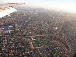
2014 aerial photo of Chollas View
SanDiegoSoutheastMap.gif
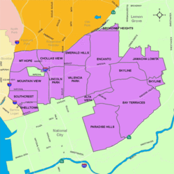
Chollas View is located in the southeastern area of the city of San Diego
Location map Southern San Diego.png
Red pog.svg
Chollas View, San Diego
Location within San Diego
Coordinates: 32°42′44″N117°05′39″W / 32.7121°N 117.0941°W / 32.7121; -117.0941
Country Flag of the United States.svg  United States of America
State Flag of California.svg  California
County Flag of San Diego County, California.png San Diego
City Flag of San Diego, California.svg San Diego
ZIP Code
92102

Chollas View is an urban community in the southeastern section of the city of San Diego. It is bordered by Webster and California State Route 94 on the north, Mount Hope and Interstate 805 on the west, Emerald Hills and Euclid Avenue on the east, and Lincoln Park and the San Diego Trolley on the south. Major thoroughfares include Market Street and 47th Street.

Contents

History

Chollas View is named after the large numbers of Cholla cactus that once covered the land. Holy Cross Cemetery opened in the area in 1919. During World War II, a defense housing project was built in the neighborhood. The neighborhood began to develop around the housing project in the 1950s. [1]

Demographics

The census tract that includes Chollas View has 4,634 residents. Chollas View neighborhood is 62.2% Hispanic, 17.8% African-American, 15.9% Asian, 4.2% multiracial, 2.8% White, 0.9% Pacific Islander, and 0.7% Native American. Chollas View has a large Laotian American population, with roughly 12% of its residents being of Laotian descent. [2]

Landmarks and facilities

The Holy Cross Cemetery is found in Chollas View.

Education

Chollas View is served by the San Diego Unified School District. Public schools in Chollas View include Gompers Preparatory Academy, Millennial Tech Middle School and Horton Elementary School.


See also

Related Research Articles

Tierrasanta, San Diego Community of San Diego in California

Tierrasanta, Spanish for "holy land," or "holy ground", is a community within the city of San Diego, California. The symbol of Tierrasanta is an encircled Conquistador cross, similar to one atop Montserrat (mountain) near Barcelona, Spain, though it no longer holds any religious meaning. The community is referred to as "The Island in the Hills" by locals and on welcome signs, as there are only four roads that lead to Tierrasanta, all which end within the community.

Mount Hope, San Diego Community of San Diego in California

Mount Hope is an ethnically diverse, hilly urban neighborhood of the City of San Diego, California. Located in the southeastern portion of the city, Mount Hope is named for the large municipal Mount Hope Cemetery, which encompasses approximately 115 acres (0.47 km2) of the community. The neighborhood contains a mixture of residential, industrial, commercial, and cemetery uses.

City Heights, San Diego Community of San Diego in California

City Heights is a dense urban community in central San Diego, California, known for its ethnic diversity. The area was previously known as East San Diego. City Heights is located south of Mission Valley and northeast of Balboa Park.

Paradise Hills, San Diego Community of San Diego in California

Paradise Hills is an urban neighborhood in the southeastern area of the city of San Diego, California. It is an outlying neighborhood adjacent to the independent city of National City and the unincorporated communities of Lincoln Acres and certain portions of Bonita. The neighborhood is part of the Skyline-Paradise Hills Community Planning Area.

Encanto, San Diego Community of San Diego in California


Encanto is a hilly urban neighborhood located in the southeastern part of San Diego, California. The neighborhood of Encanto is split into two sections, North Encanto, and South Encanto.

El Cerrito, Spanish for "the little hill," is a neighborhood of the Mid-City region of San Diego, California. El Cerrito is a residential neighborhood, consisting mostly of suburban homes, with some commercial activity along the streets that define its borders.

Oak Park, San Diego Community of San Diego in California

Oak Park is an urban neighborhood of the Southeast region of San Diego, California.

Southeast San Diego Community of San Diego in California

Southeast San Diego refers to the southeastern portion of the City of San Diego and the neighborhoods south of State Route 94 and east of Downtown San Diego. There are three official community planning areas: Skyline-Paradise Hills, Encanto Neighborhoods, and Southeastern.

Shelltown, San Diego Community of San Diego in California

Shelltown is a neighborhood located within Southeast San Diego, approximately 5 minutes from downtown San Diego by car and 25 minutes by bicycle. It is bordered by National City on the south, Interstate 5 and Barrio Logan on the west, 43rd Avenue on the east, and Gamma Court and the neighborhood of Southcrest on the north. Prior to the 1980s the northern border of Shelltown was National Ave and many residents still consider that the northern border.

Mountain View, San Diego Community of San Diego in California

Mountain View is an urban community in the southeastern section of the city of San Diego. It is bordered by Mount Hope and Greenwood Memorial Park on the north, Interstate 15 and the neighborhoods of Stockton and Logan Heights on the west, Interstate 805 and Lincoln Park on the east, and Southcrest and National City on the south. Major thoroughfares include Imperial Avenue and Ocean View Boulevard.

Southcrest, San Diego Community of San Diego in California

Southcrest is an urban community in the southeastern section of the city of San Diego. It is bordered by Mountain View on the north and east, Interstate 5 and the neighborhoods of Barrio Logan and Logan Heights on the west, and Shelltown on the south. Major thoroughfares include National Avenue and 40th Street.

Holy Cross Cemetery is a cemetery located in the Chollas View neighborhood of San Diego, California.

Lincoln Park, San Diego Community of San Diego in California

Lincoln Park is an urban community in the southeastern section of San Diego, California. It is bordered by Chollas View and the San Diego Trolley on the north, Mountain View and Interstate 805 on the west, Valencia Park and Euclid Avenue on the east, and National City, California on the south. Major thoroughfares include Imperial Avenue, Ocean View Boulevard, and Logan Avenue.

Emerald Hills, San Diego Community of San Diego in California

Emerald Hills is a community in the southeastern section of the city of San Diego, California, United States. It is bordered by Oak Park and California State Route 94 on the north, Chollas View and Euclid Avenue on the west, Encanto on the east, and Valencia Park and Market Street on the south. Major thoroughfares include Kelton Road and Roswell Street.

Valencia Park, San Diego Community of San Diego in California

Valencia Park is an urban community in the southeastern section of the city of San Diego. It is bordered by Emerald Hills and Market Street on the north, Lincoln Park and Euclid Avenue on the west, Encanto on the east, and Alta Vista and National City, California on the south. Major thoroughfares include Imperial Avenue, Churchward Street, and Valencia Parkway.

Broadway Heights, San Diego Community of San Diego in California

Broadway Heights is a small community in the southeastern section of the city of San Diego. It is bordered on the north, east, and west by Lemon Grove, and on the south by Encanto and Mallard Street. The predominantly African-American community has 629 residents within its seven blocks. Weston Street was renamed to Martin Luther King Jr. Way due to a youth campaign, marking the first time a street in San Diego was named after him.

Skyline, San Diego Community of San Diego in California

Skyline, also known as Skyline Hills or Greater Skyline Hills, is a hilly urban neighborhood in Southeastern San Diego. It is bordered by Encanto to the west, Jamacha-Lomita to the North East, and Bay Terraces to the South. The neighborhood is split into two sections, Skyline West and Skyline East. The neighborhood is part of the Skyline-Paradise Hills Community Planning Area.

Bay Terraces, San Diego Community of San Diego in California

Bay Terraces is a hilly urban neighborhood in the southeastern part of San Diego, California, United States. A composite of North Bay Terrace and South Bay Terrace, it is bordered by Skyline to the north, Paradise Hills to the southwest, and Alta Vista and South Encanto to the west. The southern end of the neighborhood is bordered by State Route 54 and Bonita. The neighborhood generally includes the ZIP Codes 92114 and 92139 and as such, parts of the area has often been incorrectly referred to as either "Paradise Hills" or "Skyline Hills" due to its proximity and overlapping ZIP Codes. Nevertheless, Bay Terraces is the largest neighborhood in the Skyline-Paradise Hills Community Planning Area.

Fairmount Park is a neighborhood of San Diego, California. Its borders are defined by Interstate 15 to the west, Interstate 805 to the east and California Highway 94 to the south. Its neighboring communities are South Park and Golden Hill to the west, Azalea Park and City Heights to the east, and Webster to the south. It is primarily residential, mostly single-family homes, with a small commercial area along Home Avenue including several restaurants and convenience stores. Bayridge is a small neighborhood within Fairmount Park on its westernmost knoll, identifiable by its outstanding views and well-maintained townhouse development. Fairmount Park is 3 miles from Downtown San Diego. Chollas Creek runs through it.

Memorial, San Diego Community of San Diego in California

Memorial is an urban neighborhood in the southeastern area of San Diego, California. It is generally bounded by Imperial Avenue to the north, California State Route 15 to the east, Interstate 5 to the south, and 28th Street to the west. Major thoroughfares in the neighborhood include Commercial Street, Oceanview Boulevard, and National Avenue. The San Diego Trolley runs through the area. Chollas Creek flows through the eastern edge of the neighborhood.

References

Coordinates: 32°42′44″N117°05′39″W / 32.7121°N 117.0941°W / 32.7121; -117.0941