Alta Vista, San Diego

Last updated
Alta Vista, San Diego
Alta Vista
Harbison Ave and Division St, at the border of National City and Alta Vista, Southeast San Diego, California.jpg
On the intersection of N Harbison Ave and Division St, at the border of National City and Alta Vista
Nickname(s): 
"V.P.", "P.H.", "O'Farrell Park" (widely used interchangeably due to proximity to bordering Valencia Park, O'Farrell, and Bay Terraces)
SanDiegoSoutheastMap.gif
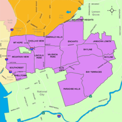
Alta Vista is located in the southeastern area of the city of San Diego
Location map Southern San Diego.png
Red pog.svg
Alta Vista, San Diego
Location within San Diego
Coordinates: 32°41′34″N117°4′2″W / 32.69278°N 117.06722°W / 32.69278; -117.06722
Country Flag of the United States.svg  United States of America
State Flag of California.svg  California
County Flag of San Diego County, California.png San Diego
City Flag of San Diego, California.svg San Diego
ZIP Code
92114

Alta Vista is a small neighborhood in southeastern San Diego, California, United States. It is bordered by National City to the west, Bay Terraces to the east, Encanto and Valencia Park to the north. [1]

Contents

With the great influx of Filipino immigrants joining the United States Navy, [2] especially from the Vietnam War era on to the 1990s, many Filipinos inhabited the Southeast San Diego neighborhoods of Alta Vista, Bay Terraces, Paradise Hills, Shelltown, Skyline Hills, and Valencia Park, both for the relatively affordable housing prices and its close proximity to Naval Base San Diego. [3]

See also

Related Research Articles

<span class="mw-page-title-main">Linda Vista, San Diego</span> Community of San Diego in California

Linda Vista is a community in San Diego, California, United States. Located east of Mission Bay, north of Mission Valley, and south-east of Tecolote Canyon, it lies on a mesa overlooking Mission Valley to the south and Mission Bay and the Pacific Ocean to the west. It is also home to the University of San Diego.

<span class="mw-page-title-main">California's 40th congressional district</span> U.S. House district for California

California's 40th congressional district is a congressional district in the U.S. state of California. The district is currently represented by Republican Young Kim. The district includes Downey, East Los Angeles, Commerce, Paramount, Bell, Bell Gardens, Bellflower, Cudahy, Huntington Park, Maywood, and the neighborhoods of Florence, Florence-Graham, Historic South Central, and South Park, in South Los Angeles. It is the most Latino district in the nation, at 86.5%.

<span class="mw-page-title-main">California's 52nd congressional district</span> U.S. House district for California

California's 52nd congressional district is a congressional district in the U.S. state of California. The district is currently represented by Democrat Juan Vargas.

<span class="mw-page-title-main">Paradise Hills, San Diego</span> Community of San Diego in California

Paradise Hills is an urban neighborhood in the southeastern area of the city of San Diego, California. It is an outlying neighborhood adjacent to the independent city of National City and the unincorporated communities of Lincoln Acres and certain portions of Bonita. The neighborhood is part of the Skyline-Paradise Hills Community Planning Area.

<span class="mw-page-title-main">Southeast San Diego</span> Community of San Diego in California

Southeast San Diego refers to the southeastern portion of the City of San Diego and the neighborhoods south of State Route 94 and east of Downtown San Diego. There are three official community planning areas: Skyline-Paradise Hills, Encanto Neighborhoods, and Southeastern.

Morena is a neighborhood in San Diego, California bordered by Bay Park to the north, Linda Vista to the east, Mission Bay to the west, and Mission Valley to the south. E. Mission Bay Drive forms the western boundary. The ZIP Code is 92110.

<span class="mw-page-title-main">Tony Young (politician)</span>

Tony Young is an American politician. He was the president of the city council of San Diego, California and served as a member of the council from 2005 to 2013, representing District 4. He is a Democrat, although the position is officially nonpartisan per California state law.

<span class="mw-page-title-main">Shelltown, San Diego</span> Community of San Diego in California

Shelltown is a neighborhood located within Southeast San Diego, approximately 5 minutes from downtown San Diego by car and 25 minutes by bicycle. It is bordered by National City on the south, Interstate 5 and Barrio Logan on the west, 43rd Avenue on the east, and Gamma Court and the neighborhood of Southcrest on the north. Prior to the 1980s the northern border of Shelltown was National Ave and many residents still consider that the northern border.

<span class="mw-page-title-main">Emerald Hills, San Diego</span> Community of San Diego in California

Emerald Hills is a neighborhood in the southeastern section of the city of San Diego, California, United States. It is bordered by Oak Park and California State Route 94 on the north, Chollas View and Euclid Avenue on the west, Encanto and Skyline Drive on the east, and Valencia Park and Market Street on the south. Major thoroughfares include Kelton Road and Roswell Street.

<span class="mw-page-title-main">Valencia Park, San Diego</span> Community of San Diego in California

Valencia Park is an urban community in the southeastern section of the city of San Diego. It is bordered by Emerald Hills and Market Street on the north, Lincoln Park and Euclid Avenue on the west, Encanto on the east, and Alta Vista and National City, California on the south. Major thoroughfares include Imperial Avenue, Churchward Street, and Valencia Parkway.

<span class="mw-page-title-main">2010 San Diego elections</span>

Municipal elections were held in San Diego in 2010 for city council and propositions. The primary election was held on June 8, 2010, and the general election was held on November 2, 2010. Four of the eight seats of the San Diego City Council were contested. This was the last election to use eight council districts. Two incumbents ran for reelection in their council district.

<span class="mw-page-title-main">2006 San Diego City Council election</span>

The 2006 San Diego City Council election occurred on November 7, 2006. The primary election was held on June 6, 2006. Four of the eight seats of the San Diego City Council were contested. All four incumbent council members stood for reelection.

<span class="mw-page-title-main">2002 San Diego City Council election</span>

The 2002 San Diego City Council election occurred on November 5, 2002. The primary election was held on March 5, 2002. Four of the eight seats of the San Diego City Council were contested. Two incumbent council members stood for reelection after having previously been elected to partial terms.

<span class="mw-page-title-main">Skyline, San Diego</span> Community of San Diego in California

Skyline, also known as Skyline Hills or Skyline Park, is a hilly urban neighborhood in Southeastern San Diego. It is bordered by Encanto to the west, Jamacha-Lomita to the North East, and Bay Terraces to the South. The neighborhood is split into two sections, Skyline West and Skyline East. The neighborhood is part of the Skyline-Paradise Hills Community Planning Area.

<span class="mw-page-title-main">Bay Terraces, San Diego</span> Community of San Diego in California

Bay Terraces is a hilly urban neighborhood in the southeastern part of San Diego, California, United States. A composite of North Bay Terrace and South Bay Terrace, it is bordered by Skyline to the north, Paradise Hills to the southwest, Alta Vista, South Encanto and National City to the west. The southern end of the neighborhood is bordered by State Route 54 and Bonita. The neighborhood generally includes the ZIP Codes 92114 and 92139 and as such, parts of the area has often been incorrectly referred to as either "Paradise Hills" or "Skyline Hills" due to its proximity and overlapping ZIP Codes. Nevertheless, Bay Terraces is the largest neighborhood in the Skyline-Paradise Hills Community Planning Area.

<span class="mw-page-title-main">Myrtle Cole</span>

Myrtle Cole is an American politician in San Diego, California. She was a member of the San Diego City Council representing City Council District 4 from 2013 until 2018. Cole served as president of the City Council from 2017 until 2018. In 2018 Cole lost a bid for reelection, becoming one of the first incumbent council members to lose a reelection campaign since 1992. She was the first African American woman elected to the city council. She is a Democrat, although city council positions are officially nonpartisan per California state law.

<span class="mw-page-title-main">Lomita, San Diego</span> Community of San Diego in California

Lomita, also known as Lomita Village, is an urban neighborhood in the southeastern area of San Diego, California. It is bounded by Meadowbrook Drive and Skyline West to the west, unincorporated La Presa to the east and Skyline East to the south, and Jamacha to the north. Major thoroughfares in the neighborhood include San Vicente Street and Worthington Avenue. The neighborhood is part of the Skyline-Paradise Hills Community Planning Area.

<span class="mw-page-title-main">Jamacha, San Diego</span> Community of San Diego in California

Jamacha is a neighborhood in the southeastern area of San Diego, California. It is generally bounded by the city of Lemon Grove to the north, unincorporated La Presa to the east, Imperial Avenue and Encanto to the west, and Skyline and Lomita Village to the south. Major thoroughfares include Lisbon Street, Jamacha Road, and Woodrow Avenue. The neighborhood is part of the Skyline-Paradise Hills Community Planning Area.

Monica Montgomery Steppe is an American politician in San Diego, California. She currently serves as a member of the San Diego City Council representing City Council District 4. She is a Democrat, although city council positions are officially nonpartisan per California state law. She serves on the board of the California Reparations Task Force.

<span class="mw-page-title-main">O'Farrell, San Diego</span> Community of San Diego in California

O'Farrell is an urban neighborhood in the southeastern region of San Diego, California. The community borders the neighborhoods of Encanto to the north, Skyline and North Bay Terrace to the east, Alta Vista to the south, and Valencia Park to the west.

References

  1. "Map of Alta Vista, San Diego". Archived from the original on 2010-11-06. Retrieved 2010-10-09.
  2. "Journal of San Diego History" . Retrieved 2007-11-17.
  3. "San Diego Reader - Their Own Paradise" . Retrieved 2020-11-17.

Coordinates: 32°50′24″N117°16′37″W / 32.84000°N 117.27694°W / 32.84000; -117.27694