Torrey Highlands, San Diego

Last updated
Torrey Highlands, San Diego
Torrey Highlands
SanDiegoMapTorreyHighlands.jpg
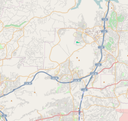
Torrey Highlands and neighborhood boundaries
Location map Northeastern San Diego.png
Red pog.svg
Torrey Highlands, San Diego
Location within Northeastern San Diego
San Diego County California Incorporated and Unincorporated areas.svg
Red pog.svg
Torrey Highlands, San Diego
Torrey Highlands, San Diego (San Diego County, California)
Coordinates: 32°58′06.28″N117°09′31.78″W / 32.9684111°N 117.1588278°W / 32.9684111; -117.1588278
Country Flag of the United States.svg  United States of America
State Flag of California.svg  California
County Flag of San Diego County, California.png San Diego
City Flag of San Diego, California.svg San Diego

Torrey Highlands is a primarily residential community in northern San Diego, California. Most of the community has been developed from 2000 to present.

Contents

History

Before Torrey Highlands became a residential community, the area was largely used for agricultural purposes.

In 1980, the area received an influx of displaced migrant villagers from the Rancho Diablo encampment in Pacific Highlands Ranch, who lived off of the land while working on the farms in the area. [1] The community of Rancho Diablo lived in between the canyons before being evicted from Torrey Highlands in the 2010s.

In 1996, the Torrey Highlands Subarea Plan was approved by the City Council and by the voters of the City of San Diego, graduating from the North City Future Urbanizing Area plan. [2]

The community was mostly built in the 2000s as a largely residential community with the State Route 56 cutting through the community.

Geography

Torrey Highlands is bordered: to the north by Black Mountain Ranch; to the south by Del Mar Mesa; to the east by Rancho Peñasquitos; to the west by Pacific Highlands Ranch; and to the northwest by Fairbanks Ranch.

The Torrey Highlands Subarea Plan was approved in 1996 by voters and the City Council. The Torrey Highlands Subarea Plan limited dwelling units to no more than 2,600 and designated 50 percent of Torrey Highlands for residential development, 30 percent for parks and open space, 12 percent for schools, 5 percent for commercial, and 3 percent for employment centers. [3]

Demographics

According to January 2006 estimates by the San Diego Association of Governments, [4] there were 2,401 people and 227 households residing in the neighborhood, which increased 29,912.5% from 8 people and 2 households in 2000. The estimated racial makeup was 58.6% White, 30.5% Asian & Pacific Islander, 5.5% Hispanic, 4.0% from other races, 1.3% African American, and 0.2% American Indian. The median age is 39.9 with 28.2% under the age of 18 and 8.5% over the age of 65. The estimated median household income was $130,086 ($101,899 adjusted for inflation in 1999 dollars); 20.7% of the community made more than $150,000; 63.0% made between $60,000 and $149,999; and 16.3% made less than $60,000.

Education

Torrey Highlands is served by the Poway Unified School District, including Westview High School, which is located within the neighborhood.

Related Research Articles

<span class="mw-page-title-main">Bonita, California</span> Census-designated place in California, United States

Bonita is a census-designated place (CDP) in southern San Diego County, California, nestled between the cities of Chula Vista, National City, and San Diego. The population was 12,538 at the 2010 census.

<span class="mw-page-title-main">Escondido, California</span> City in California, United States

Escondido is a city in San Diego County, California, United States. Located in the North County region, it was incorporated in 1888, and is one of the oldest cities in San Diego County. It has a population of 151,038 as of the 2020 census.

<span class="mw-page-title-main">Ramona, San Diego County, California</span> Census designated place in California, United States

Ramona is a census-designated place (CDP) in San Diego County, California. The population was 20,292 at the 2010 census.

<span class="mw-page-title-main">Scripps Ranch, San Diego</span> Community of San Diego in California, United States

Scripps Ranch is a community of San Diego, California in the northeastern part of that city. Its ZIP code is 92131. It is located east of Interstate 15, north of Marine Corps Air Station Miramar, and south of Poway.

<span class="mw-page-title-main">Carmel Valley, San Diego</span> Community of San Diego, California, US

Carmel Valley is a suburban planned community in the northwestern corner of San Diego, California, United States. The community is composed of commercial offices, residential units, hotels, retail stores and restaurants.

<span class="mw-page-title-main">Rancho Bernardo, San Diego</span> Community of San Diego in California

Rancho Bernardo is a master-planned community in the northern hills of the city of San Diego, California.

<span class="mw-page-title-main">Rancho Peñasquitos, San Diego</span> Community of San Diego in California, United States

Rancho Peñasquitos is a suburban community in the northeastern part of the city of San Diego, California. It is named after the first Mexican land grant in the county, Rancho Santa Maria de Los Peñasquitos. The community abuts Los Peñasquitos Canyon Preserve, an open space preserve that offers hiking, biking, and equestrian trails. The community is commonly abbreviated "PQ."

<span class="mw-page-title-main">Black Mountain Ranch, San Diego</span> Community of San Diego in California

Black Mountain Ranch is a suburban community in the northern part of the city of San Diego, California 92127. Black Mountain Ranch encompasses 5,100 acres (21 km2) and is located north of Rancho Peñasquitos and Torrey Highlands, south of the Santa Fe Valley, east of Fairbanks Ranch and Rancho Santa Fe, and west of 4S Ranch.

<span class="mw-page-title-main">Torrey Hills, San Diego</span> Community of San Diego in California

Torrey Hills is a community of 784 acres (317 ha) located in northern San Diego, California, United States. Torrey Hills is a part of District 1 which is represented by Councilmember Joe LaCava on the San Diego City Council.

<span class="mw-page-title-main">Carmel Mountain Ranch, San Diego</span> Community of San Diego in California

Carmel Mountain Ranch, sometimes shortened to simply Carmel Mountain, or abbreviated to CMR by local residents and organizations is a community of San Diego, California, United States, in the northeastern part of the city. Despite its name, Carmel Mountain Ranch is actually in the shadow of Black Mountain. Carmel Mountain proper is about 10 miles west of the Carmel Mountain Ranch neighborhood.

<span class="mw-page-title-main">Del Mar Mesa, San Diego</span> Community of San Diego in California, United States

Del Mar Mesa is a semi-rural residential community of 2,042 acres (8.26 km2) located in northern San Diego, California. The majority of the community was developed in the 2000s. Over 900 acres is preserved open space protected habitat. The community also has 10 miles of hiking, biking and riding trails. Minimum lot size is half acre. Del Mar Mesa is a part of District 1 which is represented by Councilmember Joe LaCava on the San Diego City Council.

<span class="mw-page-title-main">Pacific Highlands Ranch, San Diego</span> Community of San Diego in California

Pacific Highlands Ranch is a primarily residential community of approximately 2,652 acres (1,073 ha) in northern San Diego, California. As part of San Diego City Council District 1, it is represented by Joe LaCava, elected in 2020, and as part of District 3 of the San Diego County Board of Supervisors, it is represented by Terra Lawson-Remer, also elected in 2020. Both had not been elected to those positions before.

<span class="mw-page-title-main">Torrey Pines, San Diego</span> Neighborhood in San Diego, California

Torrey Pines is a community neighborhood of 2,600 acres (1,100 ha) in the northern coastal area of San Diego, California, residential with large areas of office space along I-5.

Rancho Santa Maria de Los Peñasquitos was a 8,486-acre (34.34 km2) Mexican land grant in present-day southwestern San Diego County, California given in 1823 to Francisco María Ruiz. The name means "Saint Mary of the Little Cliffs". It encompassed the present-day communities of Mira Mesa, Carmel Valley, and Rancho Peñasquitos in northern San Diego city, and was inland from the Torrey Pines State Natural Preserve bluffs.

Rincon del Diablo is a community in San Diego County, California. Because it predates Escondido and other geopolitical boundaries, it does not necessarily correspond to present day definitions.

North City is a neighborhood in San Diego, California bordered by Solana Beach and Rancho Santa Fe to the north, Del Mar Heights to the west, and Carmel Valley to the south. I-5 forms the western boundary. The name is almost never used by local residents as the area is already included in either Rancho Santa Fe or Carmel Valley. The name is almost exclusively used by the San Diego Police Department for zoning.

<span class="mw-page-title-main">2012 San Diego elections</span>

Municipal elections were held in San Diego in 2012 for mayor, city attorney, five seats to the San Diego City Council, and propositions. The primary election was held on June 5, 2012, and the general election was held on November 6, 2012. This was the first city council election to use nine council districts. Two city council incumbents ran for reelection in their same district and one ran for election in the newly created ninth district.

<span class="mw-page-title-main">2008 San Diego City Council election</span>

The 2008 San Diego City Council election occurred on November 4, 2008. The primary election was held on June 5, 2008. Four of the eight seats of the San Diego City Council were contested. This was the last election for the odd-numbered districts using the boundaries created by the 2000 Redistricting Committee. No incumbent council members were eligible to run for reelection due to term limits.

<span class="mw-page-title-main">2004 San Diego City Council election</span>

The 2004 San Diego City Council election occurred on November 2, 2004. The primary election was held on March 2, 2004. Four of the eight seats of the San Diego City Council were contested. This election used the boundaries created by the 2000 Redistricting Committee for the odd-numbered districts. All four incumbent council members ran for reelection in their respective districts.

<span class="mw-page-title-main">2020 San Diego elections</span>

Municipal elections were held in San Diego in 2020 for mayor, city attorney, and city council. The primary election occurred Tuesday, March 3, 2020, and the general election occurred Tuesday, November 3, 2020. Five of the nine council seats were contested. No council incumbents stood for reelection.

References

  1. Environmental Impact Report: PACIFIC HIGHLANDS RANCH (SUBAREA Ill) SUBAREA PLAN in the NORTH CITY FUTURE URBANIZING AREA (NCFUA). https://www.sandiego.gov/sites/default/files/dsderp_pts432080_02.pdf
  2. "Community Profiles: Torrey Highlands | Planning Department | City of San Diego Official Website". www.sandiego.gov. Retrieved 2020-09-12.
  3. "Torrey Highlands Community Profile". San Diego Government . Retrieved 2007-03-23.{{cite web}}: External link in |publisher= (help)
  4. "Population and Housing Estimates: Torrey Highlands Community Planning Area" (PDF). SANDAG (San Diego Association of Governments). Retrieved 2007-03-23.