Southcrest, San Diego | |
---|---|
Southcrest | |
![]() On 40th St, looking north, towards the Southcrest neighborhood | |
![]() Southcrest is located in the southeastern area of the city of San Diego | |
Coordinates: 32°41′36″N117°06′48″W / 32.6932°N 117.1132°W | |
Country | ![]() |
State | ![]() |
County | ![]() |
City | ![]() |
ZIP Code | 92113 |
Southcrest is an urban community in the southeastern section of San Diego, California. It is bordered by Mountain View to the north and east, Interstate 5 and the neighborhoods of Barrio Logan and Logan Heights to the west, and Shelltown to the south. Major thoroughfares include National Avenue and 40th Street.
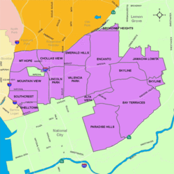
Prior to the 1980s the Southcrest area was part of the neighborhood Shelltown and many residents still consider this area Shelltown. [1] The neighborhood was to have been bifurcated by a planned freeway - California State Route 252 - which would have connected Interstate 805 to Interstate 5. [2] This freeway has been deleted, and a portion of the previous right of way has been developed into the 252 Corridor Park. Many of the older homes in this area were destroyed in anticipation of the freeway and later replaced with tract housing. The area was renamed Southcrest shortly after.
Southcrest is a diverse neighborhood and home to one of the highest concentrations of Latinos in the City. Current demographics for the neighborhood are as follows: people of Hispanic/Latino heritage make up 89.5%, followed by African-Americans at 4.5%, Asian at 2.4%, non-Hispanic Whites 2.0%, and Mixed Race at 1.5%. [3] It ranked last out of 125 San Diego neighborhoods in terms of lowest percentage of non-Hispanic whites, and 1 out of 125 San Diego neighborhoods in terms of total population that is non-White (roughly 98.0%). [3]
A portion of Chollas Creek runs through Southcrest on its way to San Diego Bay. 252 Corridor Park parallels much of the creekbed through the neighborhood. 252 Corridor Park has been renamed Southcrest Trails Park. San Diego's Southcrest Trails Park is located in Southcrest, within the Chollas Creek floodplain, part of the smallest watershed in San Diego and containing the highest population density. The Park itself is located south of Boston Avenue and west of South 38th Street. [4] The park was scheduled to be completed in December 2012. [5] In the heart of Southcrest lies the first Samoan church of any denomination in the United States. The church started in 1955 at the Naval Base, but didn't build their sanctuary until 1964. The church is located at 1345 South 45th Street.
Southcrest is located within the 9th City Council District, currently represented by Jennifer Campbell. It is part of the Southeastern San Diego Planning Area. [6]
Southcrest is served by San Diego Unified School District.
Mount Hope is an ethnically diverse, hilly urban neighborhood in San Diego, California. Located in the southeastern portion of the city, Mount Hope is named for the large municipal Mount Hope Cemetery, which encompasses approximately 115 acres (0.47 km2) of the community. The neighborhood contains a mixture of residential, industrial, commercial, and cemetery uses.
City Heights is a dense urban community in central San Diego, California, known for its ethnic diversity. The area was previously known as East San Diego. City Heights is located south of Mission Valley and northeast of Balboa Park.
Logan Heights is an urban neighborhood in central San Diego, California. It is bordered by Interstate 5 on the south and west, Interstate 15 on the east, and Imperial Avenue on the north. It is part of the Southeastern Planning Area.
Barrio Logan is a neighborhood in south central San Diego, California. It is bordered by the neighborhoods of East Village and Logan Heights to the north, Shelltown and Southcrest to the east, San Diego Bay to the southwest, and National City to the southeast. Interstate 5 forms the northeastern boundary. The Barrio Logan Community Plan Area comprises approximately 1,000 acres, of which slightly more than half is under the jurisdiction of the Port of San Diego or the United States Navy rather than the city of San Diego. The community is subject to the California Coastal Act. Though located near the city's central core, it has long been considered part of Southeast San Diego by many locals, being directly southeast of downtown San Diego, and with previous historical records labeling it as part of "Western Southeast San Diego."
California's 52nd congressional district is a congressional district in the U.S. state of California. The district is currently represented by Democrat Juan Vargas.
Paradise Hills is an urban neighborhood in the southeastern area of the city of San Diego, California. It is an outlying neighborhood adjacent to the independent city of National City and the unincorporated communities of Lincoln Acres and certain portions of Bonita. The neighborhood is part of the Skyline-Paradise Hills Community Planning Area.
Encanto is a hilly urban neighborhood located in the southeastern region of San Diego, California. The neighborhood is bordered by California State Route 94 and the communities of Oak Park and Broadway Heights to the north, O'Farrell to the south, Emerald Hills and Valencia Park to the west and the city of Lemon Grove to the east.
Oak Park is an urban neighborhood in the Southeast region of San Diego, California.
Southeast San Diego refers to the southeastern portion of San Diego, including the neighborhoods south of State Route 94 and east of downtown San Diego. Southeast San Diego has no official definition, but it may be considered coterminous with three official planning areas: Skyline-Paradise Hills, Chollas Valley, and Southeastern.
Sherman Heights is an urban neighborhood in central San Diego, California, bordered by Golden Hill to the north, Grant Hill to the east, East Village to the west, and Logan Heights to the south. It is part of the Southeastern Planning Area.
Chollas Creek, also referred to as Las Chollas Creek, is an urban creek in San Diego County, California, United States, that is 30 miles (48 km) long. The Chollas Creek's four branches begin in the cities of Lemon Grove and La Mesa and empties into San Diego Bay at Barrio Logan. Bifurcating into two main forks, the creek may also be dry during the Southern California dry season. Multiple plant, animal, and aquatic wildlife species live in or around the creek, including the rare plants Juncus acutus leopoldii and Iva hayesiana, and the threatened Coastal California gnatcatcher.
Shelltown is a neighborhood in San Diego, California, located within Southeast San Diego. It is bordered by National City to the south, Interstate 5 and Barrio Logan to the west, 43rd Avenue to the east, and Gamma Court and the neighborhood of Southcrest to the north. Prior to the 1980s the northern border of Shelltown was National Ave and many residents still consider that the northern border. Naval Base San Diego, an industrial park, and some commercial buildings are located just outside the western border of Shelltown along Main Street.
Mountain View is an urban community in the southeastern section of San Diego, California. It is bordered by Mount Hope and Greenwood Memorial Park on the north, Interstate 15 and the neighborhoods of Stockton and Logan Heights on the west, Interstate 805 and Lincoln Park on the east, and Southcrest and National City on the south. Major thoroughfares include Imperial Avenue and Ocean View Boulevard.
Chollas View is an urban community in the southeastern section of San Diego, California. It is bordered by Webster and California State Route 94 on the north, Mount Hope and Interstate 805 on the west, Emerald Hills and Euclid Avenue on the east, and Lincoln Park and the San Diego Trolley on the south. Major thoroughfares include Market Street and 47th Street.
Lincoln Park is an urban community in the southeastern section of San Diego, California. It is bordered by Chollas View and the San Diego Trolley to the north, Mountain View and Interstate 805 to the west, Valencia Park and Euclid Avenue to the east, and National City, California, to the south. Major thoroughfares include Imperial Avenue, Ocean View Boulevard, and Logan Avenue.
Emerald Hills is a neighborhood in the southeastern section of San Diego, California, United States. It is bordered by Oak Park and California State Route 94 on the north, Chollas View and Euclid Avenue on the west, Encanto and Skyline Drive on the east, and Valencia Park and Market Street on the south. Major thoroughfares include Kelton Road and Roswell Street.
Valencia Park is an urban community in the southeastern section of San Diego, California, United States. It is bordered by Emerald Hills and Market Street on the north, Lincoln Park and Euclid Avenue to the West, Encanto to the east, and Alta Vista and National City, California, to the south. Major thoroughfares include Imperial Avenue, Churchward Street, and Valencia Parkway.
Fairmount Park is a neighborhood of San Diego, California. Its borders are defined by Interstate 15 to the west, Interstate 805 to the east and California Highway 94 to the south. Its neighboring communities are South Park and Golden Hill to the west, Azalea Park and City Heights to the east, and Webster to the south. It is primarily residential, mostly single-family homes, with a small commercial area along Home Avenue including several restaurants and convenience stores. Bayridge is a small neighborhood within Fairmount Park on its westernmost knoll, identifiable by its outstanding views and well-maintained townhouse development. Fairmount Park is 3 miles from downtown San Diego. Chollas Creek runs through it.
Memorial is an urban neighborhood in the southeastern area of San Diego, California. It is generally bounded by Imperial Avenue to the north, California State Route 15 to the east, Interstate 5 to the south, and 28th Street to the west. Major thoroughfares in the neighborhood include Commercial Street, Oceanview Boulevard, and National Avenue. The San Diego Trolley runs through the area. Chollas Creek flows through the eastern edge of the neighborhood.
Jamacha is a neighborhood in the southeastern area of San Diego, California. It is generally bounded by the city of Lemon Grove to the north, unincorporated La Presa to the east, Imperial Avenue and Encanto to the west, and Skyline and Lomita Village to the south. Major thoroughfares include Lisbon Street, Jamacha Road, and Woodrow Avenue. The neighborhood is part of the Skyline-Paradise Hills Community Planning Area.