Kearny Mesa, San Diego

Last updated
Kearny Mesa, San Diego
Kearny Mesa
KearnyMesa convoy.JPG
Convoy Street in Kearny Mesa
Location map Northwestern San Diego.png
Red pog.svg
Kearny Mesa, San Diego
Location within Northwestern San Diego
Coordinates: 32°49′30″N117°08′21″W / 32.825°N 117.139167°W / 32.825; -117.139167
Country Flag of the United States.svg  United States of America
State Flag of California.svg  California
County Flag of San Diego County, California.png San Diego
City Flag of San Diego, California.svg San Diego

Kearny Mesa is a community in the central part of San Diego, California. It is bounded by State Route 52 to the north, Interstate 805 to the west, Aero Drive to the south, and Interstate 15 to the east. Adjacent communities include Serra Mesa, Clairemont and Tierrasanta.

Contents

Kearny Mesa has a population of 2,837. [1]

History

Defense worker housing under construction at Kearny Mesa in 1941. Photo by Russell Lee. Federal Works Agency defense constr 1941.jpg
Defense worker housing under construction at Kearny Mesa in 1941. Photo by Russell Lee.

Kearny Mesa is named for the former Camp Kearny, a U.S. military base which operated in the area from 1917 to 1946 and eventually became Marine Corps Air Station Miramar. Camp Kearny in turn was named for Brigadier General Stephen W. Kearny, a leader in the Mexican–American War who also served as a military governor of California. [2] While General Kearny's name was pronounced "Car-nee" during his lifetime, [3] San Diegans use the "Cur-nee" pronunciation. [4]

The urbanization of Kearny Mesa began in 1937 with Gibbs Airfield, now the small airfield Montgomery Field named after pioneer glider pilot John J. Montgomery. [5] In 1948, the City of San Diego acquired the airfield and 1,400 acres (6 km2) of surrounding property as a possible replacement site for San Diego International Airport. However, airspace conflicts with MCAS Miramar (at that time NAS Miramar) made the proposed airport infeasible. Montgomery Field was restricted to small aircraft, and the surplus land was converted to an industrial park.

Beginning in 1955 with General Dynamics, numerous aerospace, electronic, and other industrial and office firms located in the area. There was also commercial development, particularly west of State Route 163.

On October 20, 2020, the Convoy District was designated as the Convoy Pan Asian Cultural & Business Innovation District.

Geography

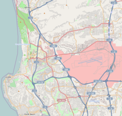
As implied by the word "mesa" in its name, the area is mostly flat. Kearny Mesa is located between the communities of Clairemont to the west, Tierrasanta to the east, Miramar/Mira Mesa to the north, and Linda Vista/Serra Mesa to the south. The neighborhood is defined by the City of San Diego as the area bounded by State Route 52 (SR 52), Interstate 15 (I-15), Aero Drive, and I-805. [6] The city also includes in its definition a stretch of land extending south of Aero Drive along the west side of I-15 to its junction with Friars Road. [6]

Montgomery Field is a local municipal airport in Kearny Mesa. [7] The community is also adjacent to Marine Corps Air Station Miramar. [8]

There are several residential developments in the community, among them Stonecrest, Kearny Lodge, and Royal Highlands.

Climate

Kearny Mesa has a semi-arid climate (Köppen climate classification: BSk) with mild winters and warm, almost rainless summers.

Climate data for Montgomery-Gibbs Executive Airport (normals 1998–2020, extremes 1998–present)
MonthJanFebMarAprMayJunJulAugSepOctNovDecYear
Record high °F (°C)88
(31)
91
(33)
93
(34)
100
(38)
102
(39)
100
(38)
106
(41)
105
(41)
107
(42)
105
(41)
99
(37)
86
(30)
107
(42)
Mean maximum °F (°C)81.5
(27.5)
81.4
(27.4)
83.5
(28.6)
86.7
(30.4)
85.7
(29.8)
86.4
(30.2)
91.4
(33.0)
92.9
(33.8)
98.4
(36.9)
93.4
(34.1)
88.3
(31.3)
80.1
(26.7)
101.7
(38.7)
Mean daily maximum °F (°C)67.3
(19.6)
67.3
(19.6)
68.5
(20.3)
70.7
(21.5)
72.1
(22.3)
74.7
(23.7)
79.8
(26.6)
82.0
(27.8)
81.4
(27.4)
77.8
(25.4)
72.7
(22.6)
67.3
(19.6)
73.5
(23.1)
Daily mean °F (°C)56.6
(13.7)
57.1
(13.9)
59.1
(15.1)
61.5
(16.4)
64.4
(18.0)
67.3
(19.6)
71.9
(22.2)
73.7
(23.2)
72.5
(22.5)
67.8
(19.9)
61.4
(16.3)
56.3
(13.5)
64.1
(17.8)
Mean daily minimum °F (°C)46.0
(7.8)
46.9
(8.3)
49.6
(9.8)
52.4
(11.3)
56.6
(13.7)
60.0
(15.6)
64.0
(17.8)
65.3
(18.5)
63.6
(17.6)
57.8
(14.3)
50.1
(10.1)
45.3
(7.4)
54.8
(12.7)
Mean minimum °F (°C)37.6
(3.1)
38.2
(3.4)
42.0
(5.6)
45.0
(7.2)
50.4
(10.2)
55.2
(12.9)
60.4
(15.8)
61.5
(16.4)
57.1
(13.9)
50.3
(10.2)
42.0
(5.6)
36.6
(2.6)
35.0
(1.7)
Record low °F (°C)30
(−1)
33
(1)
39
(4)
37
(3)
44
(7)
48
(9)
57
(14)
55
(13)
52
(11)
43
(6)
34
(1)
32
(0)
30
(−1)
Average precipitation inches (mm)2.32
(59)
2.65
(67)
1.63
(41)
0.77
(20)
0.28
(7.1)
0.06
(1.5)
0.07
(1.8)
0.01
(0.25)
0.17
(4.3)
0.54
(14)
0.91
(23)
1.61
(41)
11.02
(280)
Average precipitation days (≥ 0.01 in)6.87.96.55.12.81.00.60.31.33.66.17.149.1
Source: NOAA [9]

Economy

The majority of the Kearny Mesa area is commercial and industrial. Local businesses include auto sales, restaurants (primarily American and Asian), supermarkets (American and Asian), national chain stores, and small businesses. The former General Dynamics site is now a mixed-use development known as Spectrum. [10]

Convoy District (Convoy Pan Asian Cultural & Business Innovation District)

Chinese shops in Kearny Mesa KearnyMesa.jpg
Chinese shops in Kearny Mesa

The Convoy District is distinguished by the number of diverse businesses owned and representative of different Asian cultures such as Chinese, Korean, Japanese, Vietnamese, and Thai shopping and eating establishments. Some of these extend to the east/central areas (near Balboa Avenue, along State Route 163).

The presence of Asian businesses in the Convoy District area is said to have started with the establishment of a Woo Chee Chong grocery store on Convoy Street in 1979. [11] The Korean market chain Zion opened its first store in the Convoy District, also in 1979. [11] A few years later, in 1986, Nijiya Market (a Japanese market located in the southwestern portion of the Convoy District), opened its very first store; it later expanded to more than ten locations in California and Hawaii. [12] These early establishments served as small anchors, and additional Asian shops and restaurants opened nearby. As the area's reputation for its Asian cuisine and merchandise grew, more widely established Asian chain stores such as 99 Ranch Market, Mitsuwa, and H Mart also began setting up sites in the Convoy District. [11]

On October 20, 2020 Convoy District was designated as the Convoy Pan Asian Cultural & Business Innovation District after local businesses, tenants, storeowners, and non profit organizations pushed for the name change. [13] Their efforts were brought to San Diego City Council Member, Chris Cate, and Assembly member Todd Gloria, whom they worked with to put the name change into effect. [14]

Many different community based organizations and fundraisers support and push for the promotion of local businesses within the Convoy Pan Asian Cultural & Business Innovation District. Convoy District Partnership, one of these organizations, helped fundraise over $30,000 to help create 6 different highway signs that help in the promotion of this district. [15]

Government

The San Diego County Registrar of Voters San Diego County Registrar of Voters.jpg
The San Diego County Registrar of Voters

The area is split between City Council District 6, represented by Councilman Kent Lee, [16] and District 7, represented by Councilman Raul Campillo. [17]

The original 1977 Serra Mesa Community Plan included Kearny Mesa. It was replaced by the 1992 Kearny Mesa Community Plan which applies just to Kearny Mesa. The Montgomery Field Master Plan also contains land use policies for areas adjacent to the airport.

The County of San Diego maintains a large complex, housing several county offices and services, in the northeastern corner of the neighborhood near the I-15/SR 52 interchange. Several other city and county facilities are located in or adjacent to the area, including the Miramar Landfill.

Community groups

The Kearny Mesa Planning Group advises the city on land use and other issues.

See also

Related Research Articles

<span class="mw-page-title-main">Miramar, San Diego</span> Community of San Diego in California

Miramar is a neighborhood in the northern part of the city of San Diego, California, United States. It includes residential areas and commercial and light industrial districts.

<span class="mw-page-title-main">Marine Corps Air Station Miramar</span> USMC installation that is home to the 3rd Marine Aircraft Wing

Marine Corps Air Station Miramar, formerly Naval Auxiliary Air Station (NAAS) Miramar and Naval Air Station (NAS) Miramar, is a United States Marine Corps installation that is home to the 3rd Marine Aircraft Wing, which is the aviation element of the 1st Marine Expeditionary Force. It is located in Miramar, San Diego, California, about 14 miles (23 km) north of Downtown San Diego.

<span class="mw-page-title-main">Tierrasanta, San Diego</span> Community of San Diego in California

Tierrasanta, Spanish for "holy land," or "holy ground", is a community within the city of San Diego, California. The symbol of Tierrasanta is an encircled Conquistador cross, similar to one atop Montserrat (mountain) near Barcelona, Spain, though it no longer holds any religious meaning. The community is referred to as "The Island in the Hills" by locals and on welcome signs, as there are only four roads that lead to Tierrasanta, all which end within the community.

<span class="mw-page-title-main">Area codes 619 and 858</span> Area codes for San Diego County, California

Area codes 619 and 858 are telephone area codes in the North American Numbering Plan (NANP) for most of San Diego County in the U.S. state of California. Area code 619 was created by a split of area code 714 in 1982. In 1999, a part of the 619 numbering plan area was assigned area code 858 in northwest San Diego County. In 2019, the area code boundary between 619 and 858 was eliminated, creating an overlay complex with the two area codes.

<span class="mw-page-title-main">San Diego Public Library</span> Public library system in San Diego, CA

The San Diego Public Library is a public library system serving the city of San Diego, California.

<span class="mw-page-title-main">San Diego-Imperial Council</span>

The San Diego-Imperial Council is headquartered in San Diego, California, and serves youth members and volunteer leaders through Scout units in San Diego and Imperial counties of Southern California, as well as a portion of Arizona.

<span class="mw-page-title-main">University City, San Diego</span> Community of San Diego in California

University City (UC) is a community in San Diego, California, located in the northwestern portion of the city next to the University of California, San Diego. The area was originally intended to serve as housing for the faculty of the university, hence the name.

<span class="mw-page-title-main">San Carlos, San Diego</span> Community of San Diego in California

San Carlos is a neighborhood in the eastern area of San Diego, California. It borders the neighborhoods of Del Cerro, Tierrasanta, Allied Gardens, the city of La Mesa, and Mission Trails Regional Park. The neighborhood extends to Cowles Mountain at the north.

<span class="mw-page-title-main">Serra Mesa, San Diego</span> Community of San Diego in California, United States

Serra Mesa is a community in San Diego, California, roughly between Interstate 805 and Interstate 15, north of Friars Road and south of Aero Drive. It is named for Junípero Serra, a Majorcan (Spain) Franciscan friar who founded the Mission San Diego de Alcalá. Adjacent communities include Kearny Mesa, Tierrasanta, Mission Valley, and Linda Vista.

<span class="mw-page-title-main">Clairemont, San Diego</span> Community of San Diego in California

Clairemont is a community within the city of San Diego, California, United States. It has a population of about 81,600 residents and an area of roughly 13.3 square miles (34 km2). Clairemont Mesa is bordered by Interstate 805 on the east, Interstate 5 to the west, State Route 52 to the north, and the community of Linda Vista to the south. The community of Clairemont Mesa can be subdivided into the neighborhoods of North Clairemont, Clairemont Mesa East, Clairemont Mesa West, Bay Park, and Bay Ho.

<span class="mw-page-title-main">Birdland, San Diego</span> Community of San Diego in California

Birdland is a neighborhood in San Diego, California. It is located between California State Route 163, Interstate 805 and Mission Valley. Most of the streets in the area are named after different bird species, hence the name of the community.

San Diego College of Continuing Education

San Diego College of Continuing Education (SDCCE) is a public, noncredit educational institution in San Diego, California. It is part of the San Diego Community College District along with three two-year community colleges: San Diego City, San Diego Mesa and San Diego Miramar colleges. SDCCE is administered by the San Diego Community College District and is fully accredited by the Western Association of Schools and Colleges. SDCCE is the nation's largest separately-accredited noncredit continuing education institution.

<span class="mw-page-title-main">Lorie Zapf</span> American politician

Lorie Zapf is an American politician in San Diego, California. She served as a San Diego City Council member representing City Council District 2. She was first elected to office in November 2010 serving District 6, but switched districts in 2014 due to redistricting. In 2018 Zapf lost a bid for reelection, becoming one of the first incumbent council members to lose a reelection campaign since 1992. She is a Republican, although city council positions are officially nonpartisan per California state law.

<span class="mw-page-title-main">2006 San Diego City Council election</span>

The 2006 San Diego City Council election occurred on November 7, 2006. The primary election was held on June 6, 2006. Four of the eight seats of the San Diego City Council were contested. All four incumbent council members stood for reelection.

<span class="mw-page-title-main">2004 San Diego City Council election</span>

The 2004 San Diego City Council election occurred on November 2, 2004. The primary election was held on March 2, 2004. Four of the eight seats of the San Diego City Council were contested. This election used the boundaries created by the 2000 Redistricting Committee for the odd-numbered districts. All four incumbent council members ran for reelection in their respective districts.

<span class="mw-page-title-main">2002 San Diego City Council election</span>

The 2002 San Diego City Council election occurred on November 5, 2002. The primary election was held on March 5, 2002. Four of the eight seats of the San Diego City Council were contested. Two incumbent council members stood for reelection after having previously been elected to partial terms.

<span class="mw-page-title-main">2018 San Diego City Council election</span>

The 2018 San Diego City Council election occurred on November 6, 2018. The primary election was held June 5, 2018. Four of the nine seats of the San Diego City Council were contested.

<span class="mw-page-title-main">1959 San Diego F3H crash</span> Aircraft accident

The 1959 San Diego F3H crash was the crash of a United States Navy McDonnell F3H-2N Demon in San Diego, California, on 4 December 1959. The pilot, Ensign Albert Joseph Hickman from VF-121, chose not to eject from the stricken aircraft, piloting it away from populated areas of Clairemont, including an elementary school, saving "as many as 700 people" on the ground, according to one estimate. The aircraft crashed into a canyon, with the pilot being the sole fatality. Hickman has been memorialized in the naming of an elementary school and a sports complex in San Diego. Several decades later, a similar crash occurred in University City, a neighborhood north of Clairemont.

<span class="mw-page-title-main">2020 San Diego elections</span>

Municipal elections were held in San Diego in 2020 for mayor, city attorney, and city council. The primary election occurred Tuesday, March 3, 2020, and the general election occurred Tuesday, November 3, 2020. Five of the nine council seats were contested. No council incumbents stood for reelection.

References

  1. "Kearny Mesa Demographics and Statistics". Niche. Retrieved 2023-11-01.
  2. Fetzer, Leland, San Diego County Place Names A to Z, page 73, Sunbelt Publications, Inc, 2005, ISBN   978-0-932653-73-4
  3. Howe, Daniel Walker, What Hath God Wrought: The Transformation of America 1815–1848. ISBN   978-0-19-507894-7, p. 758.
  4. Ken Kramer's About San Diego | Kearny Mesa name | Season 2 , retrieved 2020-07-20
  5. Harwood, Craig S. and Fogel, Gary B. Quest for Flight: John J. Montgomery and the Dawn of Aviation in the West, University of Oklahoma Press 2012.]
  6. 1 2 "Kearny Mesa Community Plan". City of San Diego Official Website. City of San Diego. 5 June 2022. Retrieved 14 September 2023.
  7. "Montgomery Field – Airports". The City of San Diego. 2013. Retrieved 2013-08-10.
  8. "Official website of MCAS Miramar". USMC MCAS Miramar. Archived from the original on 2013-07-29. Retrieved 2013-08-10.
  9. "NWS San Diego NOAA Online Weather Data". NOAA. Retrieved February 8, 2021.
  10. Biberman, Thor Kamban (August 11, 2004). "San Diego Spectrum dominates Kearny Mesa construction". San Diego Daily Transcript . Archived from the original on October 24, 2015. Retrieved June 18, 2014.
  11. 1 2 3 Johnson, Troy (2021-05-27). "How Convoy Became the Heart of San Diego's Asian Food Scene". San Diego Magazine.
  12. Goto, Asami (2013-10-18). ""Shokuiku" activities at Nijiya Market Thinking about the future of shokuiku activities that pass on the Japanese food culture in America". www.discovernikkei.org.
  13. Wu, Sabrina (November 1, 2020), "San Diego Convoy District Designated as Pan-Asian Cultural and Business Hub", UCSD Guardian
  14. Marx, Jesse (2022-10-03). "Council Race to Test the Voting Power of Asian Empowerment District". Voice of San Diego. Retrieved 2022-10-21.
  15. Rendon-Alvarez, Karla; Gomez • •, Nicole. "New Freeway Signs Will Guide Drivers to Convoy District". NBC 7 San Diego. Retrieved 2022-10-21.
  16. "Chris & Staff | Councilmember Kent Lee (District 6) | City of San Diego Official Website".
  17. "Chris & Staff | Councilmember Raul Campillo (District 7) | City of San Diego Official Website".

32°49′30″N117°8′21″W / 32.82500°N 117.13917°W / 32.82500; -117.13917