Mountain View, San Diego

Last updated
Mountain View, San Diego
Mountain View
SanDiegoSoutheastMap.gif
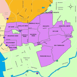
Mountain View is located in the southeastern area of the city of San Diego
Location map Southern San Diego.png
Red pog.svg
Mountain View, San Diego
Location within San Diego
Coordinates: 32°42′10″N117°06′42″W / 32.7027°N 117.1118°W / 32.7027; -117.1118
Country Flag of the United States.svg  United States of America
State Flag of California.svg  California
County Flag of San Diego County, California.png San Diego
City Flag of San Diego, California.svg San Diego
ZIP Code
92113
San Miguel Mountain seen from Mountain View Logan Avenue.jpg
San Miguel Mountain seen from Mountain View

Mountain View is an urban community in the southeastern section of the city of San Diego. It is bordered by Mount Hope and Greenwood Memorial Park on the north, Interstate 15 and the neighborhoods of Stockton and Logan Heights on the west, Interstate 805 and Lincoln Park on the east, and Southcrest and National City on the south. Major thoroughfares include Imperial Avenue and Ocean View Boulevard.

Contents

History

The area comprising Mountain View was acquired by the city of San Diego in 1874, and Mountain View Park was dedicated in 1914. [1]

Demographics

Mountain View is a diverse community. Current demographics for the neighborhood are as follows: people of Hispanic heritage make up 76.8%, followed by African-American at 12.1%, then non-Hispanic Whites at 5.3%, Asian at 3.9%, Mixed race at 1.8%, and Others at 0.1%. [2]

Landmarks and facilities

Mountain View abuts two of the largest and oldest cemeteries in San Diego County - Mount Hope Cemetery and Greenwood Memorial Park.

Government

Mountain View is located within the 9th City Council District, currently represented by Sean Elo-Rivera. It is part of the Southeastern San Diego Planning Area. [3]

Education

Mountain View is served by the San Diego Unified School District. Public schools in Mountain View include Baker Elementary and Promise Charter School. It is also home to Educational Cultural Complex (ECC), San Diego City College's flagship Continued Education campus. [4]

See also

Related Research Articles

<span class="mw-page-title-main">Mount Hope, San Diego</span> Community of San Diego in California

Mount Hope is an ethnically diverse, hilly urban neighborhood of the City of San Diego, California. Located in the southeastern portion of the city, Mount Hope is named for the large municipal Mount Hope Cemetery, which encompasses approximately 115 acres (0.47 km2) of the community. The neighborhood contains a mixture of residential, industrial, commercial, and cemetery uses.

<span class="mw-page-title-main">College Area, San Diego</span> Community of San Diego in California

The College Area is a residential community in the Mid-City region of San Diego, California, United States. The College Area is dominated by San Diego State University, after which the area is named. Several neighborhoods in the College Area were developed in the 1930s, with others becoming established in the post-war period. The College Area is bordered on the west by Kensington and Talmadge and on the east by the city of La Mesa. El Cajon Boulevard is a busy shopping district; additional retail, entertainment and dining establishments are located in a new housing and commercial complex known as South Campus Plaza on College Avenue at Aztec Center. The College Area includes the neighborhoods of the Catoctin Area, Dennstedt Point, East Falls View Drive, Saranac-Mohawk, and an Orthodox Jewish neighborhood in the area near Congregation Beth Jacob Orthodox Synagogue on College Avenue. The region includes Alvarado Hospital, a 306-bed acute care facility, and the College-Rolando branch of the San Diego Public Library.

<span class="mw-page-title-main">Normal Heights, San Diego</span> Community of San Diego in California

Normal Heights is a neighborhood of the mid-city region of San Diego, California.

<span class="mw-page-title-main">Logan Heights, San Diego</span> Community of San Diego in California

Logan Heights is an urban neighborhood in central San Diego, California. It is bordered by Interstate 5 on the south and west, Interstate 15 on the east, and Imperial Avenue on the north. It is part of the Southeastern Planning Area.

<span class="mw-page-title-main">Paradise Hills, San Diego</span> Community of San Diego in California

Paradise Hills is an urban neighborhood in the southeastern area of the city of San Diego, California. It is an outlying neighborhood adjacent to the independent city of National City and the unincorporated communities of Lincoln Acres and certain portions of Bonita. The neighborhood is part of the Skyline-Paradise Hills Community Planning Area.

<span class="mw-page-title-main">Clairemont, San Diego</span> Community of San Diego in California

Clairemont is a community within the city of San Diego, California, United States. It has a population of about 81,600 residents and an area of roughly 13.3 square miles (34 km2). Clairemont Mesa is bordered by Interstate 805 on the east, Interstate 5 to the west, State Route 52 to the north, and the community of Linda Vista to the south. The community of Clairemont Mesa can be subdivided into the neighborhoods of North Clairemont, Clairemont Mesa East, Clairemont Mesa West, Bay Park, and Bay Ho.

<span class="mw-page-title-main">Encanto, San Diego</span> Community of San Diego in California

Encanto is a hilly urban neighborhood located in the southeastern region of San Diego, California. The neighborhood is bordered by California State Route 94 and the communities of Oak Park and Broadway Heights to the north, O'Farrell to the south, Emerald Hills and Valencia Park to the west and the City of Lemon Grove to the east.

<span class="mw-page-title-main">Cortez Hill, San Diego</span> Neighborhood in San Diego, California

Cortez Hill is a neighborhood located in the northeast part of Downtown San Diego, California.

<span class="mw-page-title-main">Southeast San Diego</span> Community of San Diego in California

Southeast San Diego refers to the southeastern portion of the City of San Diego, including the neighborhoods south of State Route 94 and east of Downtown San Diego. Southeast San Diego has no official definition, but it may be considered coterminous with three official planning areas: Skyline-Paradise Hills, Encanto Neighborhoods, and Southeastern.

Mount Hope Cemetery is a municipal cemetery located at 3751 Market Street, San Diego, California, and gives its name to the neighborhood of Mount Hope. The cemetery is adjacent to Greenwood Memorial Park.

<span class="mw-page-title-main">Sherman Heights, San Diego</span> Community of San Diego in California

Sherman Heights is an urban neighborhood in central San Diego bordered by Golden Hill to the north, Grant Hill to the east, East Village to the west, and Logan Heights to the south. It is part of the Southeastern Planning Area.

<span class="mw-page-title-main">Shelltown, San Diego</span> Community of San Diego in California

Shelltown is a neighborhood located within Southeast San Diego, approximately 5 minutes from downtown San Diego by car and 25 minutes by bicycle. It is bordered by National City on the south, Interstate 5 and Barrio Logan on the west, 43rd Avenue on the east, and Gamma Court and the neighborhood of Southcrest on the north. Prior to the 1980s the northern border of Shelltown was National Ave and many residents still consider that the northern border.

<span class="mw-page-title-main">Southcrest, San Diego</span> Community of San Diego in California

Southcrest is an urban community in the southeastern section of the city of San Diego. It is bordered by Mountain View on the north and east, Interstate 5 and the neighborhoods of Barrio Logan and Logan Heights on the west, and Shelltown on the south. Major thoroughfares include National Avenue and 40th Street.

<span class="mw-page-title-main">Chollas View, San Diego</span> Neighborhood in San Diego, California

Chollas View is an urban community in the southeastern section of the city of San Diego. It is bordered by Webster and California State Route 94 on the north, Mount Hope and Interstate 805 on the west, Emerald Hills and Euclid Avenue on the east, and Lincoln Park and the San Diego Trolley on the south. Major thoroughfares include Market Street and 47th Street.

<span class="mw-page-title-main">Lincoln Park, San Diego</span> Community of San Diego in California

Lincoln Park is an urban community in the southeastern section of San Diego, California. It is bordered by Chollas View and the San Diego Trolley on the north, Mountain View and Interstate 805 on the west, Valencia Park and Euclid Avenue on the east, and National City, California on the south. Major thoroughfares include Imperial Avenue, Ocean View Boulevard, and Logan Avenue.

<span class="mw-page-title-main">Valencia Park, San Diego</span> Community of San Diego in California

Valencia Park is an urban community in the southeastern section of the city of San Diego. It is bordered by Emerald Hills and Market Street on the north, Lincoln Park and Euclid Avenue on the west, Encanto on the east, and Alta Vista and National City, California on the south. Major thoroughfares include Imperial Avenue, Churchward Street, and Valencia Parkway.

<span class="mw-page-title-main">Skyline, San Diego</span> Community of San Diego in California

Skyline, also known as Skyline Hills or Skyline Park, is a hilly urban neighborhood in Southeastern San Diego. It is bordered by Encanto to the west, Jamacha-Lomita to the North East, and Bay Terraces to the South. The neighborhood is split into two sections, Skyline West and Skyline East. The neighborhood is part of the Skyline-Paradise Hills Community Planning Area.

<span class="mw-page-title-main">Bay Terraces, San Diego</span> Community of San Diego in California

Bay Terraces is a hilly urban neighborhood in the southeastern part of San Diego, California, United States. A composite of North Bay Terrace and South Bay Terrace, it is bordered by Skyline to the north, Paradise Hills to the southwest, Alta Vista, South Encanto and National City to the west. The southern end of the neighborhood is bordered by State Route 54 and Bonita. The neighborhood generally includes the ZIP Codes 92114 and 92139 and as such, parts of the area has often been incorrectly referred to as either "Paradise Hills" or "Skyline Hills" due to its proximity and overlapping ZIP Codes. Nevertheless, Bay Terraces is the largest neighborhood in the Skyline-Paradise Hills Community Planning Area.

Fairmount Park is a neighborhood of San Diego, California. Its borders are defined by Interstate 15 to the west, Interstate 805 to the east and California Highway 94 to the south. Its neighboring communities are South Park and Golden Hill to the west, Azalea Park and City Heights to the east, and Webster to the south. It is primarily residential, mostly single-family homes, with a small commercial area along Home Avenue including several restaurants and convenience stores. Bayridge is a small neighborhood within Fairmount Park on its westernmost knoll, identifiable by its outstanding views and well-maintained townhouse development. Fairmount Park is 3 miles from Downtown San Diego. Chollas Creek runs through it.

<span class="mw-page-title-main">Memorial, San Diego</span> Neighborhood in California, United States

Memorial is an urban neighborhood in the southeastern area of San Diego, California. It is generally bounded by Imperial Avenue to the north, California State Route 15 to the east, Interstate 5 to the south, and 28th Street to the west. Major thoroughfares in the neighborhood include Commercial Street, Oceanview Boulevard, and National Avenue. The San Diego Trolley runs through the area. Chollas Creek flows through the eastern edge of the neighborhood.

References

  1. City of San Diego website, "Mt. View | Council District 4". Archived from the original on 2011-05-06. Retrieved 2011-02-27.
  2. ""Race and Ethnicity in Mountain View, San Diego, California"". Statistical Atlas. Retrieved 2020-11-21.
  3. "Mount Hope". City Council District 9. Retrieved 2020-11-22.
  4. "Educational Cultural Complex". San Diego City College. Retrieved 2020-11-21.

Coordinates: 32°42′11″N117°06′43″W / 32.703°N 117.112°W / 32.703; -117.112