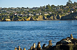
San Diego is a city on the Pacific coast of Southern California, immediately adjacent to the Mexico–United States border. With a population of over 1.3 million residents, it is the eighth-most populous in the United States and the second-most populous in the state of California, after Los Angeles. San Diego is the seat of San Diego County, which has a population of nearly 3.3 million people. It is known for its mild year-round Mediterranean climate, extensive beaches and parks, long association with the United States Navy, and recent emergence as a healthcare and biotechnology development center.

Mount Whitney is the highest mountain in the contiguous United States, with an elevation of 14,505 feet (4,421 m). It is in East–Central California, in the Sierra Nevada, on the boundary between California's Inyo and Tulare counties, and 84.6 miles (136.2 km) west-northwest of North America's lowest topographic point, Badwater Basin in Death Valley National Park, at 282 ft (86 m) below sea level. The mountain's west slope is in Sequoia National Park and the summit is the southern terminus of the John Muir Trail, which runs 211.9 mi (341.0 km) from Happy Isles in Yosemite Valley. The eastern slopes are in Inyo National Forest in Inyo County. Mount Whitney is ranked 18th by topographic isolation.

Sierra de San Pedro Mártir is a mountain range located within southern Ensenada Municipality and southern Baja California state, of northwestern Mexico.

San Jacinto Peak is a 10,834 ft (3,302 m) peak in the San Jacinto Mountains, in Riverside County, California. Lying within Mount San Jacinto State Park it is the highest both in the range and the county, and serves as the southern border of the San Gorgonio Pass. Naturalist John Muir wrote of San Jacinto Peak, "The view from San Jacinto is the most sublime spectacle to be found anywhere on this earth!"

The Santa Rosa Mountains are a short mountain range in the Peninsular Ranges system, located east of the Los Angeles Basin and northeast of the San Diego metropolitan area of southern California, in the southwestern United States.
The Laguna Mountains are a mountain range of the Peninsular Ranges in eastern San Diego County, California. The mountains run in a northwest/southeast alignment for approximately 35 miles (56 km).

Mount Humphreys is a mountain peak in the Sierra Nevada on the Fresno-Inyo county line in the U.S. state of California. It is the 13th highest peak in California, and the highest peak in the Bishop area. The mountain was named by the California Geological Survey of 1873 for Andrew A. Humphreys, the chief engineer of the United States Army at the time.

Palomar Mountain is a mountain ridge in the Peninsular Ranges in northern San Diego County, California. It is famous as the location of the Palomar Observatory and Hale Telescope, and known for the Palomar Mountain State Park.

Wilson Peak is a 14,023-foot (4,274 m) mountain peak in the U.S. state of Colorado. It is located in the Lizard Head Wilderness of the Uncompahgre National Forest, in the northwestern San Juan Mountains. It is the highest point in San Miguel County.
Lizard Head is a mountain summit in the San Miguel Mountains range of the Rocky Mountains of North America. The 13,119-foot (3,999 m) thirteener is located in the Lizard Head Wilderness, 6.8 miles (11.0 km) west by south of the Town of Ophir, Colorado, United States, on the drainage divide separating San Juan National Forest and Dolores County from Uncompahgre National Forest and San Miguel County.

Cuyamaca Peak is a mountain peak of the Cuyamaca Mountains range in San Diego County, California.
Hot Springs Mountain is a peak in the Peninsular Ranges in San Diego County, California. The mountain rises to an elevation of 6,533 feet (1,991 m) and is the highest point in the county. Some snow falls on the mountain peak during winter. It is located in a remote region of the county, four miles from the community of Warner Springs, 12 miles from Borrego Springs, and 50 miles from San Diego. The mountain and its immediate surroundings belong to the Los Coyotes Band of Cahuilla and Cupeno Indians. The summit and fire tower can be hiked via the Sukat Road route from the campground. Hikers and campers must pay an entry fee to access the area.

The San Ysidro Mountains are a mountain range in southern San Diego County, California, and Baja California, Mexico. The mountains are a rugged coastal foothill range of the Peninsular Ranges system. Major peaks include the highest summit of the range, Otay Mountain, and the Cerro San Isidro which forms the southern extrusion of the range on the Mexican side of the border. The majority of the range is within the Otay Mountain Wilderness area, in the United States.

San Diego County, officially the County of San Diego, is a county in the southwestern corner of the U.S. state of California. As of the 2020 census, the population was 3,298,634; it is the second-most populous county in California and the fifth-most populous in the United States. Its county seat is San Diego, the second-most populous city in California and the eighth-most populous in the United States. It is the southwesternmost county in the 48 contiguous United States, and is a border county. It is home to 18 Native American tribal reservations, the most of any county in the United States. There are 16 military installations of the U.S. Navy, U.S. Marine Corps, and U.S. Coast Guard in the county.

Viejas Mountain is a mountain in San Diego County, California. At 4,189 feet (1,277 m), Viejas Mountain is the 48th tallest peak in San Diego County. The mountain can be seen from parts of metropolitan San Diego. The summit is about 3 miles (5 km) northeast of the community of Alpine in the Cleveland National Forest.

The Otay Mountain Wilderness is a U.S. Wilderness Area in San Diego County, California, 12 miles east of the community of Otay Mesa and just north of the Mexico-U.S. border. Some parts of the wilderness area rise quickly from sea level, reaching a peak of just over 3,500 feet (1,100 m) at the summit of Otay Mountain.

Tecate Peak is a mountain in San Diego County, California. It is four miles west of the twin towns of Tecate, California, and Tecate, Baja California, and is about 1/2 mile north of the Mexico–United States border.

McGinty Mountain is a gabbroic mountain located in San Diego County, California near Jamul. Because of the gabbroic soil, the mountain supports numerous rare and endemic plant species, including half of California's population of the Dehesa nolina. The mountain belongs to an ecological preserve collectively managed by The Nature Conservancy, the California Department of Fish and Wildlife, and the San Diego National Wildlife Refuge. The mountain is accessible through a 4.7 mi (7.6 km) long out-and-back hiking trail.
The Cerro Bola is a coastal metavolcanic mountain formation in northwestern Baja California. The Cerro Bola, along with the nearby mountain Cerro Gordo form the highest elevation areas of Tijuana Municipality. Because of its prominence, the transmitters for television station XHDTV and radio station XHPRS-FM are located on the summit of Cerro Bola, which reaches an elevation of 1,260 m (4,130 ft). It is located approximately 35 km (22 mi) south of the Tecate border crossing, and sits at the southwest end of the Valle de Las Palmas. The mountain range is host to a number of rare and endemic plant species, such as Arctostaphylos bolensis and Ceanothus bolensis.


