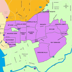
Skyline, San Diego

Last updated

Skyline, San Diego
Skyline
Nickname(s): 
"Skyline Hills", "Skyline Park"
SanDiegoSoutheastMap.gif
Skyline is located in the southeastern area of the city of San Diego
Location map Southern San Diego.png
Red pog.svg
Skyline, San Diego
Location within Southeast San Diego
Coordinates: 32°42′31″N117°02′28″W / 32.7087°N 117.0412°W / 32.7087; -117.0412
Country Flag of the United States.svg  United States of America
State Flag of California.svg  California
County Flag of San Diego County, California.png San Diego
City Flag of San Diego, California.svg San Diego

Skyline, also known as Skyline Hills or Skyline Park, [1] is a hilly urban neighborhood in Southeastern San Diego. It is bordered by Encanto to the west, Jamacha-Lomita to the North East, and Bay Terraces to the South. [2] The neighborhood is split into two sections, Skyline West and Skyline East. The neighborhood is part of the Skyline-Paradise Hills Community Planning Area. [3]

Contents

History

Prior to "white flight" in the 1960s and early 1970s, many neighborhoods in Southeast San Diego were subject to discriminatory restrictive covenants, a problem faced by African-Americans like former Councilman and Deputy Mayor George Stevens, who was denied the opportunity to purchase a house in the Skyline Hills from a white realtor. [4] Presently, much of the Skyline Hills, as well as other Encanto neighborhoods such as Emerald Hills, Lincoln Park, Mountain View, O'Farrell, South Encanto, and Valencia Park, have a substantial African-American population.

With the great influx of Filipino immigrants joining the United States Navy, [5] especially from the Vietnam War era on to the 1990s, many Filipinos inhabited the Southeast San Diego neighborhoods of Alta Vista, Bay Terraces, Paradise Hills, Shelltown, Skyline Hills, and Valencia Park, both for the relatively affordable housing prices and its close proximity to Naval Base San Diego. [6]

Geography

The Skyline-Paradise Hills Community as a whole make up approximately 4,500 acres. Much like the surrounding neighborhoods of Bay Terraces, Paradise Hills, and Jamacha-Lomita, Skyline is comprised predominantly of low-density single-family homes spread across the hilly area. A major geographic feature is Paradise Valley, which runs on an east-west axis through the middle of the community and gives rise to the Paradise Creek, which flows into San Diego Bay. Skyline, along with North Bay Terrace, Jamacha, and Lomita are north of Paradise Valley Rd. [7]

Demographics

Skyline is a very diverse neighborhood and home to one of the largest concentrations of African-Americans in the City. Current demographics for the neighborhood are as follows: people of Hispanic heritage make up 36.4%, followed by African-Americans at 31.6%, Asian at 19.9%, non-Hispanic Whites 7.0%, Mixed Race at 4.4% and others 0.6% [8] It ranked 112 out of 125 San Diego neighborhoods in terms of lowest percentage of non-Hispanic whites, and 13 out of 125 San Diego neighborhoods in terms of total population that is non-White (roughly 93.0%). [9]

Image

Much like other neighborhoods in Southeast San Diego, Skyline consists of postwar tract homes built in the 1950s and 1960's that have been outfitted with iron bars over the ground-floor windows and doors, as well as cast-iron gates and chain-link fences guarding driveways, a reflection of the perceived need for security in these historically high-crime urban neighborhoods. [10]

Skyline has endured decades of narcotic problems and gang violence, and was the target of several law enforcement operations and sweeps, targeting the Skyline East Side Piru gang in particular, an offshoot gang started by members of the Eastside Hanging Gang (EHG) and a relocated Piru gang member from Compton, and believed to be one of the largest Blood gangs in San Diego. [11] Hundreds of members of the gang have been arrested as a result of these periodic sweeps since 1990. [12] The East Side Pirus are referenced along other Piru affiliated groups as "the Skylines" in the 1993 single, "Piru Love" by Los Angeles-based rap group, Bloods & Crips. [13] They have held a long-bitter rivalry with the Lincoln Park Bloods, which has been attributed to much of the violent crime and homicides across Southeast San Diego. [14]

Lecrae in 2018 Lecrae sitting in a recording studio.jpg
Lecrae in 2018

Notable Hip Hop artist, Lecrae, who spent significant portions of his life living with his grandmother in Skyline, experienced much of the violence occurring in the community, and has paid tribute to the neighborhood in his songs including his 2013 single, "I'm Turnt," ("It's Southeast Daygo in the building, shout out to Peter Pan, Skyline, Imperial"), [15] and the 2019 single, "California Dreamin'" with 116, ("What up Southeast? (Daygo), raised me to be a lil' beast, caught a couple fades in the streets, played on the beach ...I'm rollin' down Imperial, old school in my stereo, from Skyline, you don't hear me, though (Skyline))." [16] The music video for the latter was filmed entirely in the Skyline neighborhood that he grew up in. [17]

Government

Skyline is within the 4th City Council District. [18] The district has long been represented by Myrtle Cole since she won a special election in 2013 through 2018. [19] It is currently represented by Monica Montgomery Steppe, who assumed office in 2018. [20] Federally, the neighborhood is within the California's 53rd congressional district. [21]

Education

Samuel F. B. Morse High School in the Skyline-Bay Terraces area Samuel F.B. Morse High School, San Diego, CA.jpg
Samuel F. B. Morse High School in the Skyline-Bay Terraces area

Skyline is served primarily by the San Diego Unified School District along with some charter and private schools. Schools that serve Skyline students include Morse High School, the largest school in the area, Keiller Leadership Academy, a college-preparatory charter school partnered with the University of San Diego, and The O'Farrell Charter Schools, an educational complex chartered as multiple schools in one, located at just the in-between area of Skyline and South Encanto.

Much like the rest of Southeast San Diego, many students in Skyline have taken advantage of San Diego Unified School District's Voluntary Enrollment Exchange Program (VEEP), and have opted to be bused to high schools in San Diego's more affluent northern suburban neighborhoods,. [22] Depending on their VEEP Allied School Pattern, a high school student may be voluntarily bused to Mira Mesa High School, Mission Bay High School, Scripps Ranch High School, Serra High School, and University City High School. [23]

Related Research Articles

<span class="mw-page-title-main">Paradise Hills, San Diego</span> Community of San Diego in California

<span class="mw-page-title-main">Encanto, San Diego</span> Community of San Diego in California

Encanto is a hilly urban neighborhood located in the southeastern region of San Diego, California. The neighborhood is bordered by California State Route 94 and the communities of Oak Park and Broadway Heights to the north, O'Farrell to the south, Emerald Hills and Valencia Park to the west and the City of Lemon Grove to the east.

<span class="mw-page-title-main">Morse High School (California)</span> School in San Diego, California, United States

Samuel F. B. Morse High School is an urban public high school located in southeastern San Diego in the neighborhood of Skyline Hills serving grades 9–12 in the American K-12 education system. Morse, which serves a predominantly socioeconomically-disadvantaged student population, has produced several notable athletes among its alumni

<span class="mw-page-title-main">Southeast San Diego</span> Community of San Diego in California

<span class="mw-page-title-main">Alta Vista, San Diego</span> Community of San Diego in California

Alta Vista is a small neighborhood in southeastern San Diego, California, United States. It is bordered by National City to the west, Bay Terraces to the east, Encanto and Valencia Park to the north.

<span class="mw-page-title-main">Tony Young (politician)</span>

Tony Young is an American politician. He was the president of the city council of San Diego, California and served as a member of the council from 2005 to 2013, representing District 4. He is a Democrat, although the position is officially nonpartisan per California state law.

<span class="mw-page-title-main">Shelltown, San Diego</span> Community of San Diego in California

Shelltown is a neighborhood located within Southeast San Diego, approximately 5 minutes from downtown San Diego by car and 25 minutes by bicycle. It is bordered by National City on the south, Interstate 5 and Barrio Logan on the west, 43rd Avenue on the east, and Gamma Court and the neighborhood of Southcrest on the north. Prior to the 1980s the northern border of Shelltown was National Ave and many residents still consider that the northern border.

<span class="mw-page-title-main">Lincoln Park, San Diego</span> Community of San Diego in California

Lincoln Park is an urban community in the southeastern section of San Diego, California. It is bordered by Chollas View and the San Diego Trolley on the north, Mountain View and Interstate 805 on the west, Valencia Park and Euclid Avenue on the east, and National City, California on the south. Major thoroughfares include Imperial Avenue, Ocean View Boulevard, and Logan Avenue.

<span class="mw-page-title-main">Valencia Park, San Diego</span> Community of San Diego in California

Valencia Park is an urban community in the southeastern section of the city of San Diego. It is bordered by Emerald Hills and Market Street on the north, Lincoln Park and Euclid Avenue on the west, Encanto on the east, and Alta Vista and National City, California on the south. Major thoroughfares include Imperial Avenue, Churchward Street, and Valencia Parkway.

<span class="mw-page-title-main">2010 San Diego elections</span>

Municipal elections were held in San Diego in 2010 for city council and propositions. The primary election was held on June 8, 2010, and the general election was held on November 2, 2010. Four of the eight seats of the San Diego City Council were contested. This was the last election to use eight council districts. Two incumbents ran for reelection in their council district.

<span class="mw-page-title-main">2006 San Diego City Council election</span>

The 2006 San Diego City Council election occurred on November 7, 2006. The primary election was held on June 6, 2006. Four of the eight seats of the San Diego City Council were contested. All four incumbent council members stood for reelection.

<span class="mw-page-title-main">2002 San Diego City Council election</span>

The 2002 San Diego City Council election occurred on November 5, 2002. The primary election was held on March 5, 2002. Four of the eight seats of the San Diego City Council were contested. Two incumbent council members stood for reelection after having previously been elected to partial terms.

<span class="mw-page-title-main">Bay Terraces, San Diego</span> Community of San Diego in California

Bay Terraces is a hilly urban neighborhood in the southeastern part of San Diego, California, United States. A composite of North Bay Terrace and South Bay Terrace, it is bordered by Skyline to the north, Paradise Hills to the southwest, Alta Vista, South Encanto and National City to the west. The southern end of the neighborhood is bordered by State Route 54 and Bonita. The neighborhood generally includes the ZIP Codes 92114 and 92139 and as such, parts of the area have often been incorrectly referred to as either "Paradise Hills" or "Skyline Hills" due to its proximity and overlapping ZIP Codes. Nevertheless, Bay Terraces is the largest neighborhood in the Skyline-Paradise Hills Community Planning Area.

<span class="mw-page-title-main">Myrtle Cole</span>

Myrtle Cole is an American politician in San Diego, California. She was a member of the San Diego City Council representing City Council District 4 from 2013 until 2018. Cole served as president of the City Council from 2017 until 2018. In 2018 Cole lost a bid for reelection, becoming one of the first incumbent council members to lose a reelection campaign since 1992. She was the first African American woman elected to the city council. She is a Democrat, although city council positions are officially nonpartisan per California state law.

<span class="mw-page-title-main">2014 San Diego elections</span>

Municipal elections were held in San Diego in 2014 for city council and propositions. The primary election was held on June 3, 2014, and the general election was held on November 4, 2014. Four of the nine seats of the San Diego City Council were contested. Two city council incumbents ran for re-election in their same district and one ran for election in a new district due to redistricting.

<span class="mw-page-title-main">Lomita, San Diego</span> Community of San Diego in California

<span class="mw-page-title-main">Jamacha, San Diego</span> Community of San Diego in California

<span class="mw-page-title-main">2018 San Diego City Council election</span>

The 2018 San Diego City Council election occurred on November 6, 2018. The primary election was held June 5, 2018. Four of the nine seats of the San Diego City Council were contested.

<span class="mw-page-title-main">Monica Montgomery Steppe</span> American politician

Monica Montgomery Steppe is an American politician in San Diego, California. She currently serves as a member of the San Diego City Council representing City Council District 4. She is a Democrat, although city council positions are officially nonpartisan per California state law. She serves on the board of the California Reparations Task Force.

<span class="mw-page-title-main">O'Farrell, San Diego</span> Community of San Diego in California

O'Farrell is the name of the urban region in Southeast San Diego that includes portions of Skyline, Encanto and Valencia Park. The area borders North Bay Terraces to the east and Alta Vista to the south.

References

  1. "Greater Skyline Hills | Councilmember Monica Montgomery Steppe (District 4) | City of San Diego Official Website". Sandiego.gov. Retrieved March 4, 2021.
  2. "Profile" (PDF). www.sandiego.gov. Retrieved March 4, 2021.
  3. "Community Profiles: Skyline-Paradise Hills". City of San Diego. Retrieved November 18, 2020.
  4. "George Stevens 1932–2006 11 years a councilman, always a fighter" . Retrieved November 17, 2007.
  5. "Journal of San Diego History" . Retrieved November 17, 2007.
  6. "San Diego Reader - Their Own Paradise" . Retrieved November 17, 2020.
  7. "Skyline-Paradise Hills Community Plan". Scoutred. Retrieved November 25, 2020.
  8. "Race-and-Ethnicity". Statistical Atlas. Retrieved November 18, 2020.
  9. "Race and Ethnicity in Skyline, San Diego, California". Statistical Atlas. Retrieved November 18, 2020.
  10. "On the street. Fighting crime in some of San Diego's toughest neighborhoods" . Retrieved November 22, 2007.
  11. "Released from Pelican Bay to San Diego with $200". San Diego Reader. November 7, 2012. Retrieved November 18, 2020.
  12. "96 Crips, Bloods Arrested During 'Red Rag' Sweep : Gangs: Police round up gang members on drug charges in sequel to "Operation Blue Rag."". Los Angeles Times. November 30, 1990. Retrieved November 18, 2020.
  13. "Piru Love". Genius. Retrieved November 21, 2020.
  14. "PEOPLE V. THOMAS". Casemine. Retrieved November 21, 2020.
  15. "I'm Turnt Lyrics". Genius. Retrieved November 18, 2020.
  16. ""116 & Lecrae Share Nostalgic "California Dreamin' Single & Visual"". Hot New Hip-Hop. October 1, 2019. Retrieved November 18, 2020.
  17. ""116 & Lecrae Share Nostalgic "California Dreamin'" Single & Visual"". Hot New Hip-Hop. October 1, 2019. Retrieved November 18, 2020.
  18. San Diego (Calif.) (2000). San Diego Annual Budget. City Manager. p. 895.
  19. Bowen, Andrew (July 29, 2016). "Councilwoman's Comments On Racial Profiling Spark Outcry". KPBS. San Diego. Retrieved October 4, 2017.
  20. Garrick, David (November 7, 2018). "Cole, Zapf lose re-election bids in two rare instances of San Diego council incumbents being rejected". San Diego Union-Tribune. Retrieved November 17, 2020.
  21. "A Community of Contrasts" (PDF). Union of Pan Asian Communities. Asian Americans Advancing Justice, Los Angeles. 2015. Retrieved October 4, 2017.
  22. "VEEP Information". Archived from the original on December 10, 2007. Retrieved November 17, 2007.
  23. "2007–2008 VEEP Allied Patterns" (PDF). Archived from the original (PDF) on May 2, 2008. Retrieved November 17, 2007.

32°42′31″N117°02′28″W / 32.7087°N 117.0412°W / 32.7087; -117.0412