Burlingame, San Diego

Last updated
Burlingame Historic District sign San Diego Burlingame Historic District sign.JPG
Burlingame Historic District sign

Burlingame is a neighborhood in San Diego, California, United States, bordered by North Park to the north and east, and by South Park to the south, and is located within the boundaries of the Greater North Park Community Planning Area. [1]

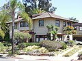
Burlingame is a historic district recognized by the City of San Diego for its Craftsman Bungalow, Tudor Revival, Mission Revival, Spanish Colonial Revival, Prairie School, Art Deco and California Ranch architectural styles as well as properties that are hybrids of several styles. [1]

Related Research Articles

<span class="mw-page-title-main">Mission Beach, San Diego</span> Community of San Diego in California

Mission Beach is a community built on a sandbar between the Pacific Ocean and Mission Bay. It is part of the city of San Diego, California.

<span class="mw-page-title-main">Panama–California Exposition</span> Exposition in California, United States

The Panama–California Exposition was a world exposition held in San Diego, California, between January 1, 1915, and January 1, 1917. The exposition celebrated the opening of the Panama Canal, and was meant to tout San Diego as the first United States port of call for ships traveling north after passing westward through the canal. The fair was held in San Diego's large urban Balboa Park. The park however also had a second Panama-California exposition again in 1935.

<span class="mw-page-title-main">North Park, San Diego</span> Neighborhood in California, US

<span class="mw-page-title-main">Golden Hill, San Diego</span> Neighborhood in San Diego, California

Golden Hill is a neighborhood of San Diego, California. It is located south of Balboa Park, north of Sherman Heights, Grant Hill and Stockton /Highway 94, and east of Downtown.

<span class="mw-page-title-main">South Park, San Diego</span>

South Park is a neighborhood in San Diego, California adjacent to the southeast corner of Balboa Park. It stands out in San Diego for its tree-lined streets and walkable business district.

<span class="mw-page-title-main">Mission Hills, San Diego</span> Community in San Diego, California

The North Park Dryden Historic District is a historic district in North Park, San Diego, 92104 along both 28th and Pershing Streets, bordered to the north by Landis Street and to the south by Upas Street. The community is a neighbourhood of early twentieth century American Craftsman Bungalows as well as Spanish Colonial Revival homes and California Bungalows built in the 1920s and 1930s. It features a high concentration of homes designed and built by the renowned Arts and Crafts era architect/builder David Owen Dryden.

<span class="mw-page-title-main">Kensington, San Diego</span> Community of San Diego in California

Kensington is a neighborhood of San Diego, California. Its borders are defined by Interstate 15 to the west, Interstate 8 to the north, Fairmount Avenue to the east, and El Cajon Boulevard to the south. Its neighboring communities are Normal Heights to the west, and City Heights to the south. Kensington is part of San Diego City Council District 9. In the United States House of Representatives, Kensington is in California's 53rd congressional district, represented by Democrat Sara Jacobs. Due to redistricting, it will become part of the 51st district after the 2022 congressional election.

<span class="mw-page-title-main">Talmadge, San Diego</span>

Talmadge is a neighborhood of the mid-city region of San Diego, California. Its borders are defined differently by various planning agencies, but typically include Fairmount Avenue to the west, Montezuma Road to the north, Collwood Boulevard or 51st Street to the east, and Monroe Avenue or El Cajon Boulevard to the South.

<span class="mw-page-title-main">Marina, San Diego</span> Neighborhood of San Diego in San Diego, California

The Marina district is a neighborhood in the southwest section of Downtown San Diego, California along the San Diego Bay.

<span class="mw-page-title-main">La Jolla Shores</span> Beach in La Jolla, San Diego, California

La Jolla Shores, with its northern part Scripps Beach, is a beach and vacation/residential community of the same name in La Jolla, San Diego, California. The La Jolla Shores business district is a mixed-use village encircling Laureate Park on Avenida de la Playa in the village of La Jolla Shores.

<span class="mw-page-title-main">San Diego Zoo Wildlife Alliance</span> Non-profit organisation in the U.S.

San Diego Zoo Wildlife Alliance is a not-for-profit organization headquartered in San Diego that operates the San Diego Zoo and the San Diego Zoo Safari Park. Founded in 1916 as the Zoological Society of San Diego under the leadership of Harry M. Wegeforth, the organization claims the largest zoological society membership in the world, with more than 250,000 member households and 130,000 child memberships, representing more than half a million people. The organization's mission is to save species worldwide by uniting their expertise in animal care and conservation science with their dedication to inspiring passion for nature. The San Diego Zoo and San Diego Zoo Safari Park feature a combined 15,000 animals of 750 species, not all of which are displayed publicly.

<span class="mw-page-title-main">Harry M. Wegeforth</span> American physician

Harry Milton Wegeforth was an American physician who founded the Zoological Society of San Diego and the San Diego Zoo. As a doctor he operated a thriving practice in San Diego, served briefly as president of the City Board of Health and as a surgeon for the San Diego and Arizona Railway, and established a hospital and clinic in the city's downtown district. He is best known, however, for founding the Zoological Society, which grew out of his involvement with the Panama–California Exposition in 1916, and for being the driving force behind the creation and early growth of the Zoo.

<span class="mw-page-title-main">Heritage Park (San Diego)</span>

Heritage County Park is a county park of San Diego County, California, located near Old Town San Diego State Historic Park and measuring almost eight acres. It was developed to preserve examples of San Diego's historic Victorian architecture including Italianate, Stick-Eastlake, Queen Anne and classic revival styles. The properties were all relocated from their original locations with the help of San Diego County and Save Our Heritage Organisation.

<span class="mw-page-title-main">Switzer Canyon</span> Canyon in California

Switzer Canyon is a canyon in San Diego, California. It is situated to the east of Balboa Park and serves as the boundary between the neighborhoods of North Park and South Park in Central San Diego. Switzer Canyon remains an oasis of natural vegetation between some of the city's most urban neighborhoods and is a prime example of San Diego county's unique canyon-laced topography.

<span class="mw-page-title-main">Mountain View, San Diego</span> Community of San Diego in California

Mountain View is an urban community in the southeastern section of the city of San Diego. It is bordered by Mount Hope and Greenwood Memorial Park on the north, Interstate 15 and the neighborhoods of Stockton and Logan Heights on the west, Interstate 805 and Lincoln Park on the east, and Southcrest and National City on the south. Major thoroughfares include Imperial Avenue and Ocean View Boulevard.

San Diego-Scripps Coastal Marine Conservation Area (SMCA) and Matlahuayl State Marine Reserve (SMR) are adjoining marine protected areas that extend offshore from La Jolla in San Diego County on California’s south coast. The two marine protected areas cover 2.51 square miles. San Diego-Scripps Coastal SMCA prohibits the take of all living marine resources except that coastal pelagic species, not including market squid, may be taken recreationally by hook and line. Matlahuayl SMR prohibits the take of all living marine resources.

Shirley Ann Place is a one-block-long street in the University Heights neighborhood of San Diego, California. The block, between Madison Ave. and Monroe Ave. and west of Texas Street, was designated the Shirley Ann Place Historic District by the City of San Diego for its 1920s Spanish Colonial Revival bungalows.

Rolando Park is a neighborhood on the eastern edge of San Diego, California. It is bordered by College Avenue to the west, California State Route 94 to the south, the city of La Mesa to the east and University Avenue to the north. Rolando Park borders the San Diego neighborhoods of Rolando, Redwood Village, and Oak Park.

<span class="mw-page-title-main">Plaza de Panama</span> Plaza in San Diego, California, U.S.

Plaza de Panama is a plaza in Balboa Park's El Prado Complex, in San Diego, California.

References

32°43′54″N117°7′36″W / 32.73167°N 117.12667°W / 32.73167; -117.12667