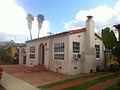
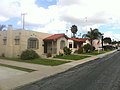
Shirley Ann Place is a one-block-long street in the University Heights neighborhood of San Diego, California. The block, between Madison Ave. and Monroe Ave. and west of Texas Street, was designated the Shirley Ann Place Historic District by the City of San Diego for its 1920s Spanish Colonial Revival bungalows. [1] [2]
The district also includes three properties similar in style and that were part of the original development:


North Park is a neighborhood in San Diego, California, United States, as well as a larger "community" as defined by the City of San Diego for planning purposes. The neighborhood is bounded:
City Heights is a dense urban community in central San Diego, California, known for its ethnic diversity. The area was previously known as East San Diego. City Heights is located south of Mission Valley and northeast of Balboa Park.

Normal Heights is a neighborhood in the mid-city region of San Diego, California.

Logan Heights is an urban neighborhood in central San Diego, California. It is bordered by Interstate 5 on the south and west, Interstate 15 on the east, and Imperial Avenue on the north. It is part of the Southeastern Planning Area.
California's 51st congressional district is a congressional district in the U.S. state of California. The district is currently represented by Democrat Sara Jacobs. The district currently includes central and eastern portions of San Diego, as well as eastern suburbs such as El Cajon, La Mesa, Spring Valley, and Lemon Grove.
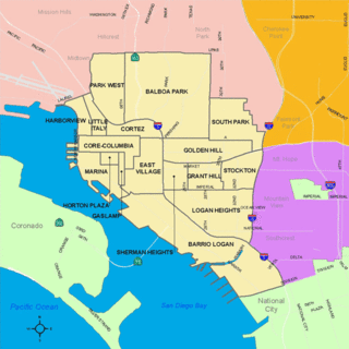
Golden Hill is a neighborhood in San Diego, California. It is located south of Balboa Park, north of Sherman Heights, Grant Hill and Stockton, and east of downtown.

University Heights is a neighborhood in San Diego, California, centered on Park Boulevard and Adams Avenue. University Heights is bounded on the west and north by the edge of the mesa, the southern boundary is Lincoln Avenue, and the eastern boundary is Texas Street. The area is filled with a number of restaurants, coffee shops, boutiques, and artist studios primarily on Park Boulevard and Adams Avenue. Live entertainment can be found most nights. Adjacent to Hillcrest, Normal Heights and North Park, additional restaurants, bars, coffee shops, and night clubs are within easy reach.

Bankers Hill is a long-established uptown neighborhood near Balboa Park in San Diego, California. The area acquired the name "Bankers Hill" because of its reputation as a home for the affluent. Many homes date from the late 19th century, some of which have been restored as offices or bed-and-breakfasts. Architects Irving Gill, William Hebbard, Richard Requa and Frank Mead designed homes in the area.
California's 52nd congressional district is a congressional district in the U.S. state of California. The district is currently represented by Democrat Juan Vargas.
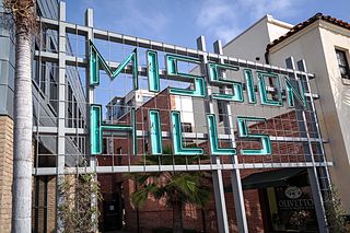
Mission Hills is a neighborhood in San Diego, California, United States. It is located on hills just south of the San Diego River valley and north of downtown San Diego and San Diego International Airport, overlooking downtown, Old Town, and San Diego Bay.
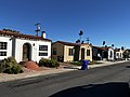
The North Park Dryden Historic District is a historic district in North Park, San Diego, along both 28th and Pershing Streets, bordered to the north by Landis Street and to the south by Upas Street. The community is a neighborhood of early twentieth century American Craftsman bungalows as well as Spanish Colonial Revival homes and California bungalows built in the 1920s and 1930s. It features a high concentration of homes designed and built by the renowned Arts and Crafts era architect/builder David Owen Dryden.

Kensington is a neighborhood in San Diego, California. Its borders are defined by Interstate 15 to the west, Interstate 8 to the north, Fairmount Avenue to the east, and El Cajon Boulevard to the south. Its neighboring communities are Normal Heights to the west, and City Heights to the south. Kensington is part of San Diego City Council District 9. In the United States House of Representatives, Kensington is in California's 53rd congressional district, represented by Democrat Sara Jacobs. Due to redistricting, it will become part of the 51st district after the 2022 congressional election.
Talmadge is a neighborhood of the mid-city region of San Diego, California. Its borders are defined differently by various planning agencies, but typically include Fairmount Avenue to the west, Montezuma Road to the north, Collwood Boulevard or 51st Street to the east, and Monroe Avenue or El Cajon Boulevard to the South.

El Cerrito is a neighborhood of the Mid-City region of San Diego, California. El Cerrito is a residential neighborhood, consisting mostly of suburban homes, with some commercial activity along the streets that define its borders.

Cortez Hill is a neighborhood in the northeast part of downtown San Diego, California.
Sherman Heights is an urban neighborhood in central San Diego, California, bordered by Golden Hill to the north, Grant Hill to the east, East Village to the west, and Logan Heights to the south. It is part of the Southeastern Planning Area.

Broadway Heights is a small community in the southeastern section of the city of San Diego, California, United States. It is bordered on the north, east, and west by Lemon Grove, and on the south by Encanto and Mallard Street. The predominantly African-American community has 629 residents within its seven blocks. Weston Street was renamed to Martin Luther King Jr. Way due to a youth campaign, marking the first time a street in San Diego was named after him.

The Asian Pacific Thematic Historic District (APTHD) is a historic Chinatown in San Diego, California. It is an eight-block district adjacent to and in part overlapping with the Gaslamp Quarter. The district is bounded by Market Street to the north, 2nd Ave. to the west, 6th Ave. to the east and J St. to the south. 22 structures are considered historically contributing.
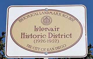
Islenair is a neighborhood and city-designated historic district in San Diego, California, often considered part of the larger City Heights neighborhood. The historic district is located along Euclid Ave., Belle Isle Dr., Isla Vista Dr., and Thorn St.

Point Loma Heights is a neighborhood in Point Loma, a community of San Diego, California. It is bounded by Froude Street on the west, Point Loma Avenue and Chatsworth Boulevard on the south, Nimitz Boulevard on the east and Midway Drive and the San Diego River on the north. Neighboring communities are Ocean Beach to the west, Sunset Cliffs and Roseville-Fleetridge to the south, Loma Portal to the east, and Midway and Mission Bay Park to the north.