
A glacier is a persistent body of dense ice that is constantly moving downhill under its own weight. A glacier forms where the accumulation of snow exceeds its ablation over many years, often centuries. It acquires distinguishing features, such as crevasses and seracs, as it slowly flows and deforms under stresses induced by its weight. As it moves, it abrades rock and debris from its substrate to create landforms such as cirques, moraines, or fjords. Although a glacier may flow into a body of water, it forms only on land and is distinct from the much thinner sea ice and lake ice that form on the surface of bodies of water.

The Jungfrau, at 4,158 meters (13,642 ft) is one of the main summits of the Bernese Alps, located between the northern canton of Bern and the southern canton of Valais, halfway between Interlaken and Fiesch. Together with the Eiger and Mönch, the Jungfrau forms a massive wall of mountains overlooking the Bernese Oberland and the Swiss Plateau, one of the most distinctive sights of the Swiss Alps.

South London is the southern part of London, England, south of the River Thames. The region consists of the boroughs, in whole or in part, of Bexley, Bromley, Croydon, Greenwich, Kingston, Lambeth, Lewisham, Merton, Richmond, Southwark, Sutton and Wandsworth.
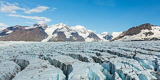
A crevasse is a deep crack that forms in a glacier or ice sheet. Crevasses form as a result of the movement and resulting stress associated with the shear stress generated when two semi-rigid pieces above a plastic substrate have different rates of movement. The resulting intensity of the shear stress causes a breakage along the faces.
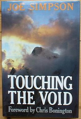
Touching the Void is a 1988 book by Joe Simpson, recounting his and Simon Yates's near fatal descent after climbing the 6,344-metre (20,814 ft) peak Siula Grande in the Peruvian Andes. Approximately 15% of the book is written by Yates. It has sold over a million copies and has been translated into over 20 languages.

Crevasse rescue is a set of techniques in mountaineering where climbers use their equipment to pull a climber, who has just fallen into a crevasse, to safety. Crevasse rescue is considered a core skill set in alpine climbing, but difficult to do efficiently. It is typically encountered by rope teams on glaciers.

A cirque is an amphitheatre-like valley formed by glacial erosion. Alternative names for this landform are corrie and cwm. A cirque may also be a similarly shaped landform arising from fluvial erosion.

A dirt cone is a type of depositional glacial feature. Dirt cones are not actually made entirely of dirt. They have a core of ice, snow, or firn that gets covered with material and insulated. The material, if it is thick enough, will protect the underlying core from ablation. The thickness of material needed to insulate the core is called the “critical thickness.” If the material is less thick than the critical thickness, it will actually speed up erosion of the core through ablation. This is called “indirect ablation.” The cone would then begin melting and shrinking away.

Vertical Limit is a 2000 American survival thriller film directed by Martin Campbell, written by Robert King, and starring Chris O'Donnell, Bill Paxton, Robin Tunney, and Scott Glenn. The film was released on December 8, 2000, in the United States by Columbia Pictures, receiving mixed reviews and grossed $215 million at the box office.

The Khumbu Icefall is located at the head of the Khumbu Glacier and the foot of the Western Cwm. It lies at an elevation of 5,486 meters on the Nepali slopes of Mount Everest, not far above Base Camp and southwest of the summit. The icefall is regarded as one of the most dangerous sections of the South Col route to Everest's summit.

A serac is a block or column of glacial ice, often formed by intersecting crevasses on a glacier. Commonly house-sized or larger, they are dangerous to mountaineers, since they may topple with little warning. Even when stabilized by persistent cold weather, they can be an impediment to glacier travel.

Beartown State Park is a 110-acre (45 ha) state park located on the eastern summit of Droop Mountain, 7 miles (11 km) southwest of Hillsboro, West Virginia, in northern Greenbrier County, West Virginia. The land was purchased in 1970 with funds from the Nature Conservancy and a donation from Mrs. Edwin G. Polan, in memory of her son, Ronald Keith Neal, a local soldier who was killed in the Vietnam War. Development of the park has been minimal in order to preserve the natural attractions of the area. Recreation in the park consists of hiking along improved trails and boardwalks. Markers explain the natural processes at work in the area. The name "Beartown State Park" was chosen because local residents claimed that many cave-like openings in the rocks made ideal winter dens for the native black bears, the state animal of West Virginia. Also because the many deep, narrow crevasses were formed in a regular criss-cross pattern which appear from above like the streets of a small town. Beartown is noted for its unusual rock formations, which consist of Droop, or Pottsville, Sandstone formed during the Pennsylvanian age. Massive boulders, overhanging cliffs and deep crevasses make up the beauty of the park. On the face of the cliffs are hundreds of eroded pits. These pits range from the size of a marble to others large enough to hold two grown men. It is not unusual to see ice and snow remaining in the deeper crevasses until midsummer.

The Athabasca Glacier is one of the six principal 'toes' of the Columbia Icefield, located in the Canadian Rockies. The glacier currently loses depth at a rate of about 5 metres (16 ft) per year and has receded more than 1.5 km (0.93 mi) and lost over half of its volume in the past 125 years. Easily accessible, it is the most visited glacier in North America. The leading edge of the glacier is within easy walking distance; however, travel onto the glacier is not recommended unless properly equipped. Hidden crevasses have led to the deaths of unprepared tourists.

A crevasse splay is a sedimentary fluvial deposit which forms when a stream breaks its natural or artificial levees and deposits sediment on a floodplain. A breach that forms a crevasse splay deposits sediments in similar pattern to an alluvial fan deposit. Once the levee has been breached the water flows out of its channel. As the water spreads onto the flood plain sediments will start to fall out of suspension as the water loses energy. The resulting deposition can create graded deposits similar to those found in Bouma sequences. In some cases crevasse splays can cause a river to abandon its old river channel, a process known as avulsion. Breaches that form a crevasse splay deposits occur most commonly on the outside banks of meanders where the water has the highest energy. Crevasse splay deposits can range in size. Larger deposits can be 6 m (20 ft) thick at the levee and spread 2 km (1.2 mi) wide, while smaller deposits may only be 1 cm (0.39 in) thick.

The Erebus Glacier Tongue is a mountain outlet glacier and the seaward extension of Erebus Glacier from Ross Island. It projects 11 kilometres (6.8 mi) into McMurdo Sound from the Ross Island coastline near Cape Evans, Antarctica. The glacier tongue varies in thickness from 50 metres (160 ft) at the snout to 300 metres (980 ft) at the point where it is grounded on the shoreline. Explorers from Robert F. Scott's Discovery Expedition (1901–1904) named and charted the glacier tongue.

Touching the Void is a 2003 survival documentary film directed by Kevin Macdonald and starring Brendan Mackey, Nicholas Aaron, and Ollie Ryall. The plot concerns Joe Simpson and Simon Yates' near-fatal descent after making the first successful ascent of the West Face of Siula Grande in the Cordillera Huayhuash in the Peruvian Andes, in 1985. It is based on Simpson's 1988 book of the same name.

A supraglacial lake is any pond of liquid water on the top of a glacier. Although these pools are ephemeral, they may reach kilometers in diameter and be several meters deep. They may last for months or even decades at a time, but can empty in the course of hours.

A randkluft or rimaye is the headwall gap between a glacier or snowfield and the adjacent rock face at the back of the cirque or, more loosely, between the rock face and the side of the glacier.

A glacier head is the top of a glacier. Although glaciers seem motionless to the observer they are in constant motion and the terminus is always either advancing or retreating.

A fissure is a long, narrow crack opening along the surface of Earth. The term is derived from the Latin word fissura, which means 'cleft' or 'crack'. Fissures emerge in Earth's crust, on ice sheets and glaciers, and on volcanoes.

