Hondo Group

Last updated
Hondo Group
Stratigraphic range:
Ortega Formation.jpg
Hondo Group (Ortega Formation) in the Tusas Mountains, New Mexico
Type Group
Sub-units Ortega Formation, Rinconada Formation
Underlies Pilar Formation
Overlies Vadito Group
Thickness2,200 m (7,200 ft)
Lithology
Primary Metasedimentary rock
Location
Coordinates 36°14′46″N105°44′42″W / 36.246°N 105.745°W / 36.246; -105.745
Region Picuris Mountains, New Mexico
Country United States
Type section
Named forHondo Canyon
Named byBauer and Williams
Year defined1989
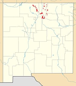
Hondo Group outcrop map.jpg
Red pog.svg
Hondo Group (New Mexico)

Map of Hondo Group outcrops

The Hondo Group is a group of geologic formations that crops out in most of the Precambrian-cored uplifts of northern New Mexico. Detrital zircon geochronology gives a maximum age for the lower Hondo Group of 1765 to 1704 million years (Mya), corresponding to the Statherian period.

Contents

Geology

The Hondo Group consists of a lower very clean quartzite (the Ortega Formation) and upper schists, quartzites, and slates. The total thickness is about 2,200 meters (7,200 feet). [1] The upper section is absent in the Tusas Mountains, where the Hondo Group is essentially synonymous with the Ortega Formation. The upper section is assigned to the Rinconada Formation in the Picuris Mountains. The most complete section is in the northern Picuris Mountains, where the Hondo Group fills an overturned syncline. [2] Detrital zircon geochronology establishes an age for the lower Hondo Group of 1765 to 1704 Mya. [3]

The Pilar and Piedra Lumbre Formations were originally included in the Hondo Group. However, a metamorphosed tuff bed in the Pilar Formation yields an age of 1488 ± 6 Mya, considerably younger than the Ortega Quartzite. The Piedra Lumbre Formation likewise contains zircons dated to 1425 Mya. This suggests that the Pilar Formation and Piedra Lumbre Formation should be removed from the Hondo Group, and provides evidence supporting the Picuris orogeny. [4]

The Hondo Group lies structurally below the Vadito Group in the Picuris Mountains. However, both groups have been severely deformed and metamorphosed, and the Vadito Group is thought to actually be the older of the two groups. Cross-bedding indicates that the Vadito Group has been overturned. [5] The contact between the two groups is fairly easy to trace using a regional manganese-rich marker bed in the uppermost Vadito Group, [2] which may have formed by syngenetic deposition from hydrothermal fluids, or a more general manganese enrichment of basin waters at the close of Vadito volcanism. Another possibility is that it is a weathering horizon. Either possibility would make it an important regional time marker. [6]

The group is interpreted as fluvial to shallow marine deposition on a southward-dipping siliciclastic shelf. Together, the Vadito Group and lower Hondo Group likely represent deposition in a back-arc basin associated with the Yavapai orogeny, named the Pilar basin. [3]

Economic geology

Gold, silver, and oxidized copper minerals were discovered on Copper Hill around 1900 and prospected over the next five years. The ore minerals were concentrated along the contact between the Ortega and Rinconada Formations. Mining began along the Champion vein on the west side of the hill, with two shaft connected by an adit 100 meters (330 feet) long. However, the mine was unsuccessful. Renewed exploratory drilling in 1982 determined that the deposits are presently uneconomical to mine. [7]

History of investigation

The unit was originally designated as the Ortega Group by Long in 1976, but this caused confusion with the Ortega Formation. The name, Hondo Group, was proposed by Bauer and Williams in 1989 as part of their sweeping revision of the Precambrian stratigraphy of northern New Mexico. [2]

Footnotes

  1. Montgomery 1953
  2. 1 2 3 Bauer and Williams 1989, p.50
  3. 1 2 Jones et al. 2011
  4. Daniel et al. 2013
  5. Bauer 2004
  6. Williams 1987
  7. Williams and Bauer 1995

Related Research Articles

<span class="mw-page-title-main">Manzano Group</span> Group of geologic formations in New Mexico, US

The Manzano Group is a group of geologic formations in central New Mexico. These have radiometric ages of 1601 to 1662 million years (Ma), corresponding to the late Statherian period of the Paleoproterozoic.

<span class="mw-page-title-main">Geology of New Mexico</span> Overview of the geology of the U.S. state of New Mexico

The geology of New Mexico includes bedrock exposures of four physiographic provinces, with ages ranging from almost 1800 million years (Ma) to nearly the present day. Here the Great Plains, southern Rocky Mountains, Colorado Plateau, and Basin and Range Provinces meet, giving the state great geologic diversity.

<span class="mw-page-title-main">Mazatzal orogeny</span> Mountain-building event in North America

The Mazatzal orogeny was an orogenic event in what is now the Southwestern United States from 1650 to 1600 Mya in the Statherian Period of the Paleoproterozoic. Preserved in the rocks of New Mexico and Arizona, it is interpreted as the collision of the 1700-1600 Mya age Mazatzal island arc terrane with the proto-North American continent. This was the second in a series of orogenies within a long-lived convergent boundary along southern Laurentia that ended with the ca. 1200–1000 Mya Grenville orogeny during the final assembly of the supercontinent Rodinia, which ended an 800-million-year episode of convergent boundary tectonism.

<span class="mw-page-title-main">Yavapai orogeny</span> Mountain building event 1.7 billion years ago in the southwestern United States

The Yavapai orogeny was an orogenic (mountain-building) event in what is now the Southwestern United States that occurred between 1710 and 1680 million years ago (Mya), in the Statherian Period of the Paleoproterozoic. Recorded in the rocks of New Mexico and Arizona, it is interpreted as the collision of the 1800-1700 Mya age Yavapai island arc terrane with the proto-North American continent. This was the first in a series of orogenies within a long-lived convergent boundary along southern Laurentia that ended with the ca. 1200–1000 Mya Grenville orogeny during the final assembly of the supercontinent Rodinia, which ended an 800-million-year episode of convergent boundary tectonism.

<span class="mw-page-title-main">Picuris orogeny</span> Mountain-building event in what is now the Southwestern US

The Picuris orogeny was an orogenic event in what is now the Southwestern United States from 1.43 to 1.3 billion years ago in the Calymmian Period of the Mesoproterozoic. The event is named for the Picuris Mountains in northern New Mexico and interpreted either as the suturing of the Granite-Rhyolite crustal province to the southern margin of the proto-North American continent Laurentia or as the final suturing of the Mazatzal crustal province onto Laurentia. According to the former hypothesis, this was the second in a series of orogenies within a long-lived convergent boundary along southern Laurentia that ended with the ca. 1200–1000 Mya Grenville orogeny during the final assembly of the supercontinent Rodinia, which ended an 800-million-year episode of convergent boundary tectonism.

<span class="mw-page-title-main">Vadito Group</span> Group of geologic formations in New Mexico, US

The Vadito Group is a group of geologic formations that crops out in most of the Precambrian-cored uplifts of northern New Mexico. Detrital zircon geochronology and radiometric dating give a consistent age of 1700 Mya for the group, corresponding to the Statherian period.

<span class="mw-page-title-main">Big Rock Formation</span>

The Big Rock Formation is a formation that crops out in the Tusas Mountains of northern New Mexico. Detrital zircon geochronology gives a maximum age for the formation of 1665 Mya, corresponding to the Statherian period.

<span class="mw-page-title-main">Burned Mountain Formation</span>

The Burned Mountain Formation is a geologic formation that crops out in the Tusas Mountains of northern New Mexico. It has a U-Pb radiometric age of 1700 Mya, corresponding to the Statherian period.

<span class="mw-page-title-main">Picuris Mountains</span> Mountain range in New Mexico

The Picuris Mountains are a mountain range in northern New Mexico. They are considered a subrange of the Sangre de Cristo Mountains.

<span class="mw-page-title-main">Glenwoody Formation</span>

The Glenwoody Formation is a geological formation that is exposed in the cliffs southeast of the Rio Grande Gorge near the town of Pilar and in a few other locations in the Picuris Mountains. Its minimum age from detrital zircon geochronology is 1.693 Mya, corresponding to the Statherian period.

<span class="mw-page-title-main">Ortega Formation</span> Geologic formation in New Mexico, US

The Ortega Formation is a geologic formation that crops out in most of the mountain ranges of northern New Mexico. Detrital zircon geochronology establishes a maximum age for the formation of 1690-1670 million years (Mya), in the Statherian period of the Precambrian.

<span class="mw-page-title-main">Rinconada Formation</span> Geologic formation in New Mexico, US

The Rinconada Formation is a geologic formation that crops out in the Picuris Mountains of northern New Mexico. Detrital zircon geochronology establishes a maximum age for the Rinconada Formation of about 1723 Mya, placing it in the Statherian period of the Precambrian.

<span class="mw-page-title-main">Pilar Formation</span> A geologic formation in New Mexico

The Pilar Formation is a geologic formation that crops out in the Picuris Mountains of northern New Mexico. It has a radiometric age of 1488 ± 6 million years, corresponding to the Calymmian period.

<span class="mw-page-title-main">Piedra Lumbre Formation</span> Geologic formation in New Mexico, US

The Piedra Lumbre Formation is a geologic formation that crops out in the Picuris Mountains of northern New Mexico. Detrital zircon geochronology yields a maximum age of 1475 million years, corresponding to the Calymmian period.

<span class="mw-page-title-main">Marquenas Formation</span> Geologic formation in New Mexico, US

The Marquenas Formation is a geological formation that crops out in the Picuris Mountains of northern New Mexico. Detrital zircon geochronology gives it a maximum age of 1435 million years, corresponding to the Calymmian period.

<span class="mw-page-title-main">Uncompahgre Formation</span>

The Uncompahgre Formation is a geologic formation in Colorado. Its radiometric age is between 1707 and 1704 Ma, corresponding to the Statherian period.

<span class="mw-page-title-main">Trampas Group</span> Group of geologic formations in New Mexico, US

The Trampas Group is a group of geologic formations that crops out in the Picuris Mountains of northern New Mexico. Detrital zircon geochronology yields a maximum age of 1475 million years, corresponding to the Calymmian period.

<span class="mw-page-title-main">Abajo Formation</span> Geologic formation in New Mexico, US

The Abajo Formation is a geologic formation in the Los Pinos Mountains of central New Mexico. It was deposited about 1660 million years (Ma) ago, corresponding to the Statherian period.

<span class="mw-page-title-main">Mazatzal Group</span> Geologic formation in Arizona, US

The Mazatzal Group is a group of geologic formations that crops out in portions of central Arizona, US. Detrital zircon geochronology establishes a maximum age for the formation of 1660 to 1630 million years (Mya), in the Statherian period of the Precambrian. The group gives its name to the Mazatzal orogeny, a mountain-building event that took place between 1695 and 1630 Mya.

The White Ledges Formation is a geologic formation that crops out in central Arizona, US. Detrital zircon geochronology establishes a maximum age for the formation of 1726 million years (Mya), in the Statherian period of the Precambrian. The formation is typical of quartzites deposited around 1650 million years ago in the southwestern part of Laurentia, the ancient core of the North American continent.

References