Meteorological history of Hurricane Gustav

Last updated

Related Research Articles

<span class="mw-page-title-main">2002 Atlantic hurricane season</span> Hurricane season in the Atlantic Ocean

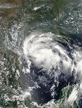
The 2002 Atlantic hurricane season was a near-average Atlantic hurricane season. It officially started on June 1, 2002, and ended on November 30, dates which conventionally limit the period of each year when most tropical cyclones develop in the Atlantic Ocean. The season produced fourteen tropical cyclones, of which twelve developed into named storms; four became hurricanes, and two attained major hurricane status. While the season's first cyclone did not develop until July 14, activity quickly picked up: eight storms developed in the month of September. It ended early however, with no tropical storms forming after October 6—a rare occurrence caused partly by El Niño conditions. The most intense hurricane of the season was Hurricane Isidore with a minimum central pressure of 934 mbar, although Hurricane Lili attained higher winds and peaked at Category 4 whereas Isidore only reached Category 3. However, Lili had a minimum central pressure of 938 mbar.

<span class="mw-page-title-main">2007 Atlantic hurricane season</span> Hurricane season in the Atlantic Ocean

The 2007 Atlantic hurricane season was the first season since 2003 to feature tropical activity both before and after the official bounds of the season. There were an above-average number of named storms during the season – 15, however many storms were weak and short-lived. Despite the predominance of weak systems, this was the first season on record to feature more than one Category 5 landfalling hurricane. This would not happen again until 2017. It produced 17 tropical cyclones, 15 tropical storms, six hurricanes, and two major hurricanes. It officially started on June 1 and ended on November 30, dates which conventionally delimit the period during which most tropical cyclones form in the Atlantic Ocean, although as shown by Subtropical Storm Andrea and Tropical Storm Olga in early May and early December, respectively, the formation of tropical cyclones is possible at any time of the year. The first system, Subtropical Storm Andrea, developed on May 9, while the last storm, Tropical Storm Olga, dissipated on December 13. The most intense hurricane, Dean, was, at the time, the third most intense landfalling Atlantic storm on record. It was the second on record in which an Atlantic hurricane, Felix, and an eastern Pacific hurricane, Henriette, made landfall on the same day. September had a then record-tying eight storms, until it was surpassed in 2020. However, the strengths and durations of most of the storms were low.

<span class="mw-page-title-main">Timeline of the 2005 Atlantic hurricane season</span>

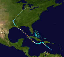
The 2005 Atlantic hurricane season was an event in the annual tropical cyclone season in the north Atlantic Ocean. It was the second most active Atlantic hurricane season in recorded history, and the most extreme in the satellite era. Officially, the season began on June 1, 2005 and ended on November 30, 2005. These dates, adopted by convention, historically delimit the period in each year when most tropical systems form. The season's first storm, Tropical Storm Arlene, developed on June 8. The final storm, Tropical Storm Zeta, formed in late December and persisted until January 6, 2006. Zeta is only the second December Atlantic storm in recorded history to survive into January, joining Hurricane Alice in 1955.

<span class="mw-page-title-main">Hurricane Lane (2006)</span> Category 3 Pacific hurricane in 2006

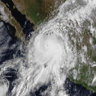
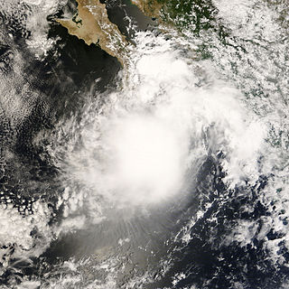
Hurricane Lane was the strongest Pacific hurricane to make landfall in Mexico since Hurricane Kenna of 2002. The thirteenth named storm, ninth hurricane, and sixth major hurricane of the 2006 Pacific hurricane season, Lane developed on September 13 from a tropical wave to the south of Mexico. It moved northwestward, parallel to the coast of Mexico, and steadily intensified in an area conducive to further strengthening. After turning to the northeast, Lane attained peak winds of 125 mph (201 km/h), and made landfall in the state of Sinaloa at peak strength. It rapidly weakened and dissipated on September 17, and later brought precipitation to southern part of the U.S. state of Texas.

<span class="mw-page-title-main">Meteorological history of Hurricane Dean</span>

The meteorological history of Hurricane Dean began in the second week of August 2007 when a vigorous tropical wave moved off the west coast of Africa into the North Atlantic ocean. Although the wave initially experienced strong easterly wind shear, it quickly moved into an environment better suited for tropical development and gained organization. On the morning of August 13, the National Hurricane Center recognized the system's organization and designated it Tropical Depression Four while it was still more than 1,500 mi (2,400 km) east of the Lesser Antilles.

<span class="mw-page-title-main">Hurricane Felix</span> Category 5 Atlantic hurricane in 2007

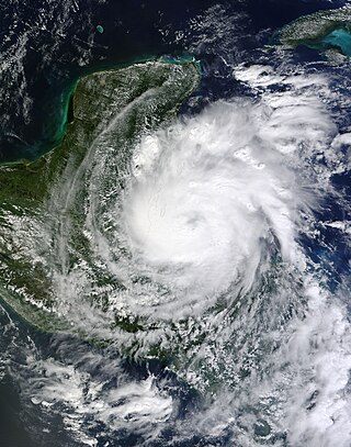
Hurricane Felix was an extremely powerful Category 5 Atlantic hurricane which was the southernmost-landfalling Category 5 storm on record, surpassing Hurricane Edith of 1971. It was the sixth named storm, second hurricane, and second Category 5 hurricane of the 2007 Atlantic hurricane season. Felix formed from a tropical wave on August 31, passing through the southern Windward Islands on September 1 before strengthening to attain hurricane status. On the next day, Felix rapidly strengthened into a major hurricane, and early on September 3 it was upgraded to Category 5 status; at 2100 UTC on the same day, the hurricane was downgraded to Category 4 status, but strengthened into a Category 5 hurricane for the second and final time by the morning of September 4.

<span class="mw-page-title-main">Tropical Storm Gabrielle (2007)</span> Atlantic tropical cyclone

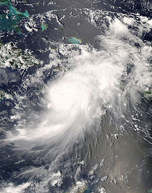
Tropical Storm Gabrielle was a short-lived tropical cyclone that passed over North Carolina before tracking out to sea. The seventh named storm of the 2007 Atlantic hurricane season, Gabrielle developed as a subtropical cyclone on September 8 about 385 miles (620 km) southeast of Cape Lookout, North Carolina. Unfavorable wind shear impacted the storm for much of its duration, although a temporary decrease in the shear allowed the cyclone to become a tropical storm. On September 9, Gabrielle made landfall at Cape Lookout National Seashore in the Outer Banks of North Carolina with winds of 60 mph (97 km/h). Turning to the northeast, the storm quickly weakened and dissipated on September 11.

<span class="mw-page-title-main">Tropical Storm Erin (2007)</span> Atlantic tropical storm

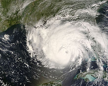
Tropical Storm Erin was a minimal tropical storm that made landfall in Texas in August 2007. The storm's remnants also unexpectedly restrengthened over Oklahoma, causing damage there as well. The second tropical cyclone to make landfall in the United States in the 2007 Atlantic hurricane season and the fifth named storm of the year, Erin formed in the Gulf of Mexico on August 14 from a persistent area of convection. It attained tropical storm status the next day, and on August 16, 2007, Erin made landfall near Lamar, Texas, and persisted over land across Texas before moving northward into Oklahoma. Due to the brown ocean effect, Erin intensified after landfall. The storm resulted in sixteen fatalities and worsened an already-severe flooding issue in Texas.

The Chicago Mercantile Exchange Hurricane Index (CMEHI) is an index which describes the potential for damage from an Atlantic hurricane in the United States. The CMEHI is used as the basis for trading hurricane futures and options on the Chicago Mercantile Exchange (CME). It is very similar to the Hurricane Severity Index, which also factors both size and intensity of a hurricane.

<span class="mw-page-title-main">Tropical Storm Kiko (2007)</span> Pacific tropical cyclone

Tropical Storm Kiko was a strong tropical storm that capsized a boat off the western coast of Mexico, killing at least 15 people. The 15th and final tropical cyclone of the 2007 Pacific hurricane season, Kiko developed out of a tropical wave that formed off the coast of Africa on September 26 and traversed the Atlantic. The wave crossed over Central America and entered the Pacific Ocean on October 8, where it spawned Tropical Depression 15-E on October 15. The depression drifted to the south over the next day before briefly being declared Tropical Storm Kiko. It subsequently weakened into a tropical depression, but later reattained tropical storm intensity. By October 18, Kiko was forecast to make landfall along the western Mexican coastline as a moderate tropical storm. However, the cyclone turned to the west and reached its peak intensity of 70 mph (110 km/h) on October 20. The tropical storm slowly weakened to a remnant low-pressure area by October 24 and completely dissipated on October 27 without making landfall.

<span class="mw-page-title-main">Tropical Storm Julio (2008)</span> Pacific tropical storm in 2008

Tropical Storm Julio was a tropical storm that made landfall on the southern tip of Baja California Sur in August 2008. The tenth named storm of the 2008 Pacific hurricane season, it developed from a tropical wave on August 23 off the coast of Mexico. It moved parallel to the coast, reaching peak winds of 50 mph (85 km/h) before moving ashore and weakening. On August 26 it dissipated in the Gulf of California. Julio was the third tropical cyclone to make landfall in the Pacific Ocean basin during the season, after Tropical Storm Alma, which struck Nicaragua in May, and Tropical Depression Five-E, which moved ashore along southwestern Mexico in July. The storm brought locally heavy rainfall to southern Baja California, killing one person and leaving several towns isolated. Moisture from Julio reached Arizona, producing thunderstorms, including one which damaged ten small planes in Chandler.

<span class="mw-page-title-main">Hurricane Gustav</span> Category 4 Atlantic hurricane in 2008

Hurricane Gustav was the second most destructive hurricane of the 2008 Atlantic hurricane season. The seventh tropical cyclone, third hurricane, and second major hurricane of the season, Gustav caused serious damage and casualties in Haiti, the Dominican Republic, Jamaica, the Cayman Islands, Cuba and the United States. Gustav caused at least $8.31 billion (2008 USD) in damages.

<span class="mw-page-title-main">2006 Pacific hurricane season</span> Hurricane season in the Pacific Ocean

The 2006 Pacific hurricane season was the first above-average season since 1997 which produced twenty-five tropical cyclones, with nineteen named storms, though most were rather weak and short-lived. Only eleven hurricanes formed and six major hurricanes. Following the inactivity of the previous seasons, forecasters predicted that season would be only slightly above active. It was also the first time since 2003 in which at least one cyclone of tropical storm intensity made landfall. The season officially began on May 15 in the East Pacific Ocean, and on June 1 in the Central Pacific; they ended on November 30. These dates conventionally delimit the period of each year when most tropical cyclones form in the Pacific basin. However, the formation of tropical cyclones is possible at any time of the year.

<span class="mw-page-title-main">Meteorological history of Hurricane Georges</span>

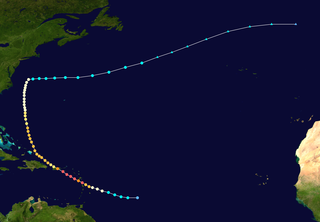
The meteorological history of Hurricane Georges spanned seventeen days from September 15 to October 1, 1998. Hurricane Georges began as a tropical wave that moved off the coast of Africa during mid-September 1998. Tracking westward, the wave spawned an area of low pressure two days later, which quickly strengthened into a tropical depression. On September 16, the depression was upgraded to Tropical Storm Georges, and to Hurricane Georges the next day. Over the next few days, an eye developed and deep Atmospheric convection persisted around it. Strong outflow and warm sea surface temperatures allowed the storm to intensify as it tracked towards the west-northwest. The storm reached its peak intensity on September 20 with winds of 155 mph (250 km/h), just below Category 5 status on the Saffir–Simpson hurricane scale, and a barometric pressure of 937 mbar.

<span class="mw-page-title-main">2017 Pacific hurricane season</span> Hurricane season in the Pacific Ocean

The 2017 Pacific hurricane season was an above average Pacific hurricane season in terms of named storms, though less active than the previous three, featuring eighteen named storms, nine hurricanes, and four major hurricanes. Despite the considerable amount of activity, most of the storms were weak and short-lived. The season officially started on May 15 in the eastern Pacific Ocean, and on June 1 in the central Pacific; they both ended on November 30. These dates conventionally delimit the period of each year when most tropical cyclones form in the respective regions. However, the formation of tropical cyclones is possible at any time of the year, as illustrated in 2017 by the formation of the season's first named storm, Tropical Storm Adrian, on May 9. At the time, this was the earliest formation of a tropical storm on record in the eastern Pacific basin proper. The season saw near-average activity in terms of accumulated cyclone energy (ACE), in stark contrast to the extremely active seasons in 2014, 2015, and 2016; and for the first time since 2012, no tropical cyclones formed in the Central Pacific basin. However, for the third year in a row, the season featured above-average activity in July, with the ACE value being the fifth highest for the month. Damage across the basin reached $375.28 million (2017 USD), while 45 people were killed by the various storms.

<span class="mw-page-title-main">Hurricane Richard</span> Category 2 Atlantic hurricane in 2010

Hurricane Richard was a damaging tropical cyclone that affected areas of Central America in October 2010. It developed on October 20 from an area of low pressure that had stalled in the Caribbean Sea. The system moved to the southeast before turning to the west. The storm slowly organized, and the system intensified into a tropical storm. Initially, Richard only intensified slowly in an area of weak steering currents. However, by October 23, wind shear diminished, and the storm intensified faster as it headed toward Belize. The next day, Richard intensified into hurricane status, and further into its peak intensity as a Category 2 hurricane, reaching maximum winds of 100 mph (160 km/h). The hurricane made its only landfall on Belize at peak intensity. Over land, Richard quickly weakened, and later degenerated into a remnant low on October 25.

<span class="mw-page-title-main">Meteorological history of Hurricane Dennis</span>

The meteorological history of Hurricane Dennis spanned twenty-two days, beginning with its inception as a tropical wave over Africa on June 26, 2005, and terminating with its dissipation on July 18 over the Great Lakes of North America. The incipient wave that became Dennis emerged over the Atlantic Ocean on June 29 and moved briskly to the west. Dry air initially inhibited development, though once this abated the wave was able to consolidate into a tropical depression on July 4. The depression soon crossed Grenada before entering the Caribbean whereupon increasingly favorable environmental factors, such as low wind shear and high sea surface temperatures, fueled intensification. Turning west-northwest, the system achieved tropical storm status on July 5 and hurricane status the following day.

<span class="mw-page-title-main">Meteorological history of Hurricane Maria</span>

Hurricane Maria was the tenth-most intense Atlantic hurricane on record and caused catastrophic damage in Puerto Rico in late September 2017. Originating from a tropical wave, it developed into a tropical depression on September 16 while situated to the east of the Lesser Antilles. Gradual intensification occurred over the next day or two and it strengthened into a tropical storm, which was named Maria. By late on September 17, Maria had intensified into a hurricane. As it approached the island arc, it underwent explosive intensification on September 18, with the hurricane reaching Category 5 intensity as it made landfall on the island of Dominica early on September 19. Land interaction weakened the storm somewhat, although it was able to quickly recover and later peaked that night with sustained winds of 175 mph (280 km/h) and a pressure of 908 mbar (26.8 inHg). Early the next morning it weakened to a high-end Category 4 hurricane before making landfall in Puerto Rico. Maria weakened significantly due to crossing the island, but was able to strengthen somewhat as it passed close to Hispaniola and The Bahamas on September 21–23. Structural changes in the hurricane as it moved further north and close to the Outer Banks in the United States ultimately caused Maria to weaken quickly. Turning away from the United States as a weakened tropical storm, it became extratropical on September 30, dissipating 3 days later.

References

  1. 1 2 3 4 5 6 7 8 9 10 11 12 13 Beven II, John L; Kimberlain, Todd B; National Hurricane Center (January 22, 2009). Hurricane Gustav (PDF) (Tropical Cyclone Report). United States National Oceanic and Atmospheric Administration's National Weather Service. p. 4. Archived (PDF) from the original on June 9, 2012. Retrieved June 1, 2012.
  2. Beven (August 18, 2008). "Tropical Weather Outlook". National Hurricane Center . Retrieved September 4, 2008.[ permanent dead link ]
  3. Rhome (August 18, 2008). "Tropical Weather Outlook". National Hurricane Center . Retrieved September 4, 2008.[ permanent dead link ]
  4. Rhome (August 19, 2008). "Tropical Weather Outlook". National Hurricane Center . Retrieved September 4, 2008.[ permanent dead link ]
  5. Blake (August 22, 2008). "Tropical Weather Outlook". National Hurricane Center . Retrieved September 4, 2008.[ permanent dead link ]
  6. Blake (August 23, 2008). "Tropical Weather Outlook". National Hurricane Center . Retrieved September 4, 2008.[ permanent dead link ]
  7. Blake/Avila (August 23, 2008). "Tropical Weather Outlook". National Hurricane Center . Retrieved September 4, 2008.[ permanent dead link ]
  8. Knabb (August 23, 2008). "Tropical Weather Outlook". National Hurricane Center . Retrieved September 4, 2008.[ permanent dead link ]
  9. Beven (August 24, 2008). "Tropical Weather Outlook". National Hurricane Center . Retrieved September 4, 2008.[ permanent dead link ]
  10. Brown/Pasch (August 25, 2008). "Tropical Weather Outlook". National Hurricane Center . Retrieved September 4, 2008.[ permanent dead link ]
  11. Beven (August 25, 2008). "Tropical Weather Outlook". National Hurricane Center . Retrieved September 4, 2008.[ permanent dead link ]
  12. Staff (August 25, 2008). "Tropical Cyclone Formation Alert". Naval Atlantic Meteorology and Oceanography Center. Archived from the original on August 30, 2008. Retrieved September 4, 2008.
  13. Beven (August 25, 2008). "Special Tropical Disturbance Statement". National Hurricane Center. Archived from the original on October 5, 2008. Retrieved September 4, 2008.{{cite web}}: CS1 maint: unfit URL (link)
  14. Pasch (August 25, 2008). "Tropical Storm Gustav Discussion Number 3". National Hurricane Center . Retrieved September 4, 2008.
  15. Franklin (August 25, 2008). "Tropical Storm Gustav Discussion Number 4". National Hurricane Center . Retrieved September 4, 2008.
  16. Franklin (August 25, 2008). "Tropical Storm Gustav Advisory Number 4". National Hurricane Center . Retrieved September 4, 2008.
  17. Blake/Avila (August 26, 2008). "Tropical Storm Gustav intermediate Advisory Number 4a". National Hurricane Center . Retrieved September 4, 2008.
  18. Blake/Avila (August 26, 2008). "Hurricane Gustav Discussion Number 5". National Hurricane Center . Retrieved September 4, 2008.
  19. Brown/Pasch (August 26, 2008). "Tropical Storm Gustav intermediate Advisory Number 5a". National Hurricane Center . Retrieved September 4, 2008.
  20. Brown/Pasch (August 26, 2008). "Hurricane Gustav Discussion Number 6". National Hurricane Center . Retrieved September 4, 2008.
  21. Pasch/Brown (August 26, 2008). "Tropical Storm Gustav intermediate Advisory Number 6a". National Hurricane Center . Retrieved September 4, 2008.
  22. Pasch (August 26, 2008). "Hurricane Gustav Forecast/Advisory Number 7". National Hurricane Center . Retrieved September 4, 2008.
  23. 1 2 Pasch (August 26, 2008). "Hurricane Gustav Advisory Number 7". National Hurricane Center . Retrieved September 4, 2008.
  24. 1 2 3 Stewart/Franklin (August 26, 2008). "Hurricane Gustav Intermediate Advisory Number 7a". National Hurricane Center . Retrieved September 4, 2008.
  25. 1 2 Stewart/Franklin (August 26, 2008). "Tropical Storm Gustav Discussion Number 8". National Hurricane Center . Retrieved September 4, 2008.
  26. Stewart/Franklin (August 26, 2008). "Tropical Storm Gustav Advisory Number 8". National Hurricane Center . Retrieved September 5, 2008.
  27. 1 2 Blake/Avila (August 27, 2008). "Tropical Storm Gustav Intermediate Advisory Number 8a". National Hurricane Center . Retrieved September 9, 2008.
  28. Blake/Avila (August 27, 2008). "Tropical Storm Gustav Discussion Number 9". National Hurricane Center . Retrieved September 9, 2008.
  29. Blake/Avila (August 27, 2008). "Tropical Storm Gustav Advisory Number 9". National Hurricane Center . Retrieved September 9, 2008.
  30. Pasch/Rhome (August 27, 2008). "Tropical Storm Gustav Intermediate Advisory Number 9a". National Hurricane Center . Retrieved September 9, 2008.
  31. Pasch/Rhome (August 27, 2008). "Tropical Storm Gustav Discussion Number 10". National Hurricane Center . Retrieved September 9, 2008.
  32. Rhome/Pasch (August 27, 2008). "Tropical Storm Gustav Discussion Number 11". National Hurricane Center . Retrieved September 9, 2008.
  33. Rhome/Pasch (August 27, 2008). "Tropical Storm Gustav Advisory Number 11". National Hurricane Center . Retrieved September 9, 2008.
  34. 1 2 Franklin (August 27, 2008). "Tropical Storm Gustav Intermediate Advisory Number 11a". National Hurricane Center . Retrieved September 9, 2008.
  35. Rhome/Pasch (August 27, 2008). "Tropical Storm Gustav Advisory Number 10a". National Hurricane Center . Retrieved September 9, 2008.
  36. Franklin (August 27, 2008). "Tropical Storm Gustav Discussion Number 12". National Hurricane Center . Retrieved September 9, 2008.
  37. Franklin (August 27, 2008). "Tropical Storm Gustav Advisory Number 12". National Hurricane Center . Retrieved September 9, 2008.
  38. Blake/Avila (August 28, 2008). "Tropical Storm Gustav Intermediate Advisory Number 12a". National Hurricane Center . Retrieved September 9, 2008.
  39. 1 2 Blake/Avila (August 28, 2008). "Tropical Storm Gustav Discussion Number 13". National Hurricane Center . Retrieved September 9, 2008.
  40. Blake/Avila (August 28, 2008). "Tropical Storm Gustav Advisory Number 13". National Hurricane Center . Retrieved September 9, 2008.
  41. Blake/Avila (August 28, 2008). "Tropical Storm Gustav Special Discussion Number 14". National Hurricane Center . Retrieved September 9, 2008.
  42. Blake/Avila (August 28, 2008). "Tropical Storm Gustav Special Advisory Number 14". National Hurricane Center . Retrieved September 9, 2008.
  43. Knabb (August 28, 2008). "Tropical Storm Gustav Discussion Number 15". National Hurricane Center . Retrieved September 9, 2008.
  44. Knabb (August 28, 2008). "Tropical Storm Gustav Advisory Number 15". National Hurricane Center . Retrieved September 9, 2008.
  45. Knabb (August 28, 2008). "Tropical Storm Gustav Intermediate Advisory Number 15a". National Hurricane Center . Retrieved September 9, 2008.
  46. Knabb (August 28, 2008). "Tropical Storm Gustav Discussion Number 16". National Hurricane Center . Retrieved September 9, 2008.
  47. Knabb (August 28, 2008). "Tropical Storm Gustav Advisory Number 16". National Hurricane Center . Retrieved September 9, 2008.
  48. Beven (August 28, 2008). "Tropical Storm Gustav Intermediate Advisory Number 16a". National Hurricane Center . Retrieved September 9, 2008.
  49. Beven (August 28, 2008). "Tropical Storm Gustav Advisory Number 17". National Hurricane Center . Retrieved September 9, 2008.
  50. Beven (August 28, 2008). "Tropical Storm Gustav Discussion Number 17". National Hurricane Center . Retrieved September 9, 2008.
  51. Encyclopedia of the Nations (2007). "Jamaica — Topography". Advameg Inc. Retrieved September 4, 2008.
  52. Blake/Avila (August 29, 2008). "Tropical Storm Gustav Advisory Number 18". National Hurricane Center . Retrieved September 9, 2008.
  53. Knabb (August 29, 2008). "Tropical Storm Gustav Intermediate Advisory Number 18a". National Hurricane Center . Retrieved September 9, 2008.
  54. Blake/Avila (August 29, 2008). "Tropical Storm Gustav Discussion Number 18". National Hurricane Center . Retrieved September 9, 2008.
  55. Knabb (August 29, 2008). "Tropical Storm Gustav Discussion Number 19". National Hurricane Center . Retrieved September 9, 2008.
  56. Knabb (August 29, 2008). "Tropical Storm Gustav Intermediate Advisory Number 19a". National Hurricane Center . Retrieved September 9, 2008.
  57. Knabb (August 29, 2008). "Hurricane Gustav Tropical Cyclone Update". National Hurricane Center . Retrieved September 9, 2008.
  58. Knabb (August 29, 2008). "Hurricane Gustav Advisory Number 20". National Hurricane Center . Retrieved September 11, 2008.
  59. 1 2 3 Knabb (August 29, 2008). "Hurricane Gustav Discussion Number 20". National Hurricane Center . Retrieved September 11, 2008.
  60. Beven (August 29, 2008). "Hurricane Gustav Intermediate Advisory Number 20a". National Hurricane Center . Retrieved September 11, 2008.
  61. Encyclopedia of the Nations (2007). "United Kingdom American Dependencies — Cayman islands". Advameg Inc. Retrieved July 13, 2009.
  62. Beven (August 29, 2008). "Hurricane Gustav Advisory Number 21". National Hurricane Center . Retrieved September 11, 2008.
  63. Beven (August 29, 2008). "Hurricane Gustav Discussion Number 21". National Hurricane Center . Retrieved September 11, 2008.
  64. Blake/Avila (August 30, 2008). "Hurricane Gustav Intermediate Advisory Number 21a". National Hurricane Center . Retrieved September 11, 2008.
  65. Blake/Avila (August 30, 2008). "Hurricane Gustav Tropical Cyclone Update". National Hurricane Center . Retrieved September 11, 2008.
  66. Blake/Avila (August 30, 2008). "Hurricane Gustav Advisory Number 22". National Hurricane Center . Retrieved September 11, 2008.
  67. Blake/Avila (August 30, 2008). "Hurricane Gustav Discussion Number 22". National Hurricane Center . Retrieved September 11, 2008.
  68. Blake/Avila (August 30, 2008). "Hurricane Gustav Tropical Cyclone Update". National Hurricane Center . Retrieved September 11, 2008.
  69. Knabb (August 30, 2008). "Hurricane Gustav Intermediate Advisory Number 22a". National Hurricane Center . Retrieved September 23, 2008.
  70. Knabb (August 30, 2008). "Hurricane Gustav Advisory Number 23". National Hurricane Center . Retrieved September 23, 2008.
  71. Knabb (August 30, 2008). "Hurricane Gustav Discussion Number 23". National Hurricane Center . Retrieved September 23, 2008.
  72. Knabb (August 30, 2008). "Hurricane Gustav Tropical Cyclone Update". National Hurricane Center . Retrieved September 23, 2008.
  73. Knabb (August 30, 2008). "Hurricane Gustav Special Discussion Number 24". National Hurricane Center . Retrieved September 23, 2008.
  74. Knabb (August 30, 2008). "Hurricane Gustav Special Forecast/Advisory Number 24". National Hurricane Center . Retrieved September 23, 2008.
  75. Knabb (August 30, 2008). "Hurricane Gustav Special Advisory Number 24". National Hurricane Center . Retrieved September 23, 2008.
  76. Knabb (August 30, 2008). "Hurricane Gustav Advisory Number 25". National Hurricane Center . Retrieved September 23, 2008.
  77. Knabb (August 30, 2008). "Hurricane Gustav Wind Speed Probabilities Number 25". National Hurricane Center . Retrieved September 23, 2008.
  78. Knabb (August 30, 2008). "Hurricane Gustav Discussion Number 25". National Hurricane Center . Retrieved September 23, 2008.
  79. 1 2 Beven (August 30, 2008). "Hurricane Gustav Intermediate Advisory Number 25a". National Hurricane Center . Retrieved September 23, 2008.
  80. Carlos J. Finlay (April 7, 2009). "Gustav's Winds Set World Record". Periodic 26. Retrieved July 15, 2009.[ dead link ]
  81. Encyclopedia of the Nations (2007). "Cuba — Topography". Advameg Inc. Retrieved July 13, 2009.
  82. 1 2 Beven (August 30, 2008). "Hurricane Gustav Discussion Number 26". National Hurricane Center . Retrieved July 13, 2009.
  83. Beven (August 31, 2008). "Hurricane Gustav Wind Speed Probabilities Number 26". National Hurricane Center . Retrieved July 13, 2009.
  84. Beven (August 30, 2008). "Hurricane Gustav Advisory Number 26, Corrected". National Hurricane Center . Retrieved July 13, 2009.
  85. Blake/Pasch (August 31, 2008). "Hurricane Gustav Intermediate Advisory Number 26a". National Hurricane Center . Retrieved July 13, 2009.
  86. Blake/Pasch (August 31, 2008). "Hurricane Gustav Advisory Number 27". National Hurricane Center . Retrieved July 13, 2009.
  87. Blake (August 31, 2008). "Hurricane Gustav Wind Speed Probabilities Number 27". National Hurricane Center . Retrieved July 13, 2009.
  88. 1 2 3 Blake/Pasch (August 31, 2008). "Hurricane Gustav Discussion Number 27". National Hurricane Center . Retrieved July 13, 2009.
  89. Beven (August 31, 2008). "Hurricane Gustav Intermediate Advisory Number 27a". National Hurricane Center . Retrieved July 13, 2009.
  90. 1 2 3 Beven (August 31, 2008). "Hurricane Gustav Discussion Number 28". National Hurricane Center . Retrieved July 13, 2009.
  91. Beven (August 31, 2008). "Hurricane Gustav Advisory Number 28". National Hurricane Center . Retrieved July 13, 2009.
  92. Beven (August 31, 2008). "Hurricane Gustav Wind Speed Probabilities Number 28". National Hurricane Center . Retrieved July 13, 2009.
  93. Beven (August 31, 2008). "Hurricane Gustav Intermediate Advisory Number 28a". National Hurricane Center . Retrieved July 13, 2009.
  94. Beven (August 31, 2008). "Hurricane Gustav Discussion Number 29". National Hurricane Center . Retrieved July 13, 2009.
  95. Franklin (August 31, 2008). "Hurricane Gustav Intermediate Advisory Number 29a". National Hurricane Center . Retrieved July 13, 2009.
  96. 1 2 Franklin (August 31, 2008). "Hurricane Gustav Discussion Number 30". National Hurricane Center . Retrieved July 13, 2009.
  97. Pasch/Berg (September 1, 2008). "Hurricane Gustav Intermediate Advisory Number 30a". National Hurricane Center . Retrieved July 13, 2009.
  98. Pasch (September 1, 2008). "Hurricane Gustav Discussion Number 31". National Hurricane Center . Retrieved July 13, 2009.
  99. Pasch/Berg (September 1, 2008). "Hurricane Gustav Advisory Number 31". National Hurricane Center . Retrieved July 13, 2009.
  100. Pasch/Berg (September 1, 2008). "Hurricane Gustav Intermediate Advisory Number 31a". National Hurricane Center . Retrieved July 13, 2009.
  101. Beven (September 1, 2008). "Hurricane Gustav Intermediate Advisory Number 31b". National Hurricane Center . Retrieved July 13, 2009.
  102. 1 2 Beven (September 1, 2008). "Hurricane Gustav Discussion Number 32". National Hurricane Center . Retrieved July 13, 2009.
  103. Beven (September 1, 2008). "Hurricane Gustav Wind Speed Probabilities Number 32". National Hurricane Center . Retrieved July 13, 2009.
  104. Beven (September 1, 2008). "Hurricane Gustav Advisory Number 32". National Hurricane Center . Retrieved July 13, 2009.
  105. Beven (September 1, 2008). "Hurricane Gustav Tropical Cyclone Position Estimate". National Hurricane Center . Retrieved July 13, 2009.
  106. Beven (September 1, 2008). "Hurricane Gustav Intermediate Advisory Number 32a". National Hurricane Center . Retrieved July 13, 2009.
  107. Beven (September 1, 2008). "Hurricane Gustav Tropical Cyclone Position Estimate". National Hurricane Center . Retrieved July 13, 2009.
  108. Beven (September 1, 2008). "Hurricane Gustav Tropical Cyclone Position Estimate". National Hurricane Center . Retrieved July 13, 2009.
  109. Beven (September 1, 2008). "Hurricane Gustav Intermediate Advisory Number 32b". National Hurricane Center . Retrieved July 13, 2009.
  110. Pasch (September 2, 2008). "Tropical Storm Gustav Intermediate Advisory Number 34a". National Hurricane Center . Retrieved July 13, 2009.
  111. Beven (September 1, 2008). "Hurricane Gustav Discussion Number 33". National Hurricane Center . Retrieved July 13, 2009.
  112. Brown/Franklin (September 1, 2008). "Tropical Storm Gustav Discussion Number 34". National Hurricane Center . Retrieved July 13, 2009.
  113. Brown (September 2, 2008). "Tropical Storm Gustav Wind Speed Probabilities Number 34". National Hurricane Center . Retrieved July 13, 2009.
  114. Pasch (September 2, 2008). "Tropical Depression Gustav Wind Speed Probabilities Number 35". National Hurricane Center . Retrieved July 13, 2009.
  115. Pasch (September 2, 2008). "Tropical Depression Gustav Discussion Number 35". National Hurricane Center . Retrieved July 13, 2009.
  116. Pasch (September 2, 2008). "Tropical Depression Gustav Advisory Number 35". National Hurricane Center . Retrieved July 13, 2009.
  117. Petersen (September 2, 2008). "Public Advisory Number 36 for Tropical Depression Gustav". Hydrometeorological Prediction Center . Retrieved July 13, 2009.
  118. Petersen (September 2, 2008). "Public Advisory Number 37 for Tropical Depression Gustav". Hydrometeorological Prediction Center . Retrieved July 13, 2009.
  119. Musher (September 2, 2008). "Public Advisory Number 38 for Tropical Depression Gustav". Hydrometeorological Prediction Center . Retrieved July 13, 2009.
  120. Musher (September 3, 2008). "Public Advisory Number 39 for Tropical Depression Gustav". Hydrometeorological Prediction Center . Retrieved July 13, 2009.
  121. Brennan (September 3, 2008). "Public Advisory Number 40 for Tropical Depression Gustav". Hydrometeorological Prediction Center . Retrieved July 13, 2009.
  122. Brennan (September 3, 2008). "Public Advisory Number 41 for Tropical Depression Gustav". Hydrometeorological Prediction Center . Retrieved July 13, 2009.
  123. Musher (September 3, 2008). "Public Advisory Number 42 for Tropical Depression Gustav". Hydrometeorological Prediction Center . Retrieved July 13, 2009.
  124. Musher (September 4, 2008). "Public Advisory Number 43 for Tropical Depression Gustav". Hydrometeorological Prediction Center . Retrieved July 13, 2009.
  125. Petersen (September 4, 2008). "Public Advisory Number 44 for Tropical Depression Gustav". Hydrometeorological Prediction Center . Retrieved July 13, 2009.
  126. Petersen (September 4, 2008). "Public Advisory Number 45 for Tropical Depression Gustav". Hydrometeorological Prediction Center . Retrieved July 13, 2009.
  127. Chicago, IL Weather Forecast Office (September 5, 2008). "Storm Total Rainfall Amount". National Weather Service . Retrieved July 13, 2009.
  128. GRR Webmaster (September 5, 2008). "Gustav Brings Heavy Rain to Parts of Southwest Michigan". National Weather Service Weather Forecast Office, Grand Rapids, MI. Retrieved September 5, 2008.
  129. ARX Webmaster (September 5, 2008). "Remains of Gustav Bring Rare Rainfall to the Region". National Weather Service Weather Forecast Office, La Crosse, WI. Retrieved September 5, 2008.
Hurricane Gustav
Gustav 2008 track.png
Track of Hurricane Gustav