
Bridge City is a city in Orange County,Texas,United States. It is 100 miles east of Houston,near the Gulf of Mexico. The population was 9,546 at the 2020 census. The town borders the Neches River and Cow Bayou. It is part of the Beaumont–Port Arthur Metropolitan Statistical Area. The area is mostly known for its association with the petroleum products (oil) industry.

Hurricane Floyd was a very powerful Cape Verde hurricane which struck the Bahamas and the East Coast of the United States. It was the sixth named storm,fourth hurricane,and third major hurricane in the 1999 Atlantic hurricane season. Floyd triggered the fourth largest evacuation in US history when 2.6 million coastal residents of five states were ordered from their homes as it approached. The hurricane formed off the coast of Africa and lasted from September 7 to 19,becoming extratropical after September 17,and peaked in strength as a very strong Category 4 hurricane. It was among the largest Atlantic hurricanes of its strength ever recorded,in terms of gale-force diameter.

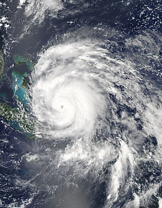
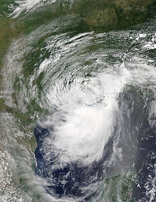
Hurricane Isabel was the strongest Atlantic hurricane since Mitch,and the deadliest,costliest,and most intense hurricane in the 2003 Atlantic hurricane season. Hurricane Isabel was also the strongest hurricane in the open waters of the Atlantic,both by wind speed and central pressure,before being surpassed by hurricanes Irma and Dorian in 2017 and 2019,respectively. The ninth named storm,fifth hurricane,and second major hurricane of the season,Isabel formed near the Cape Verde Islands from a tropical wave on September 6,in the tropical Atlantic Ocean. It moved northwestward,and within an environment of light wind shear and warm waters,it steadily strengthened to reach peak winds of 165 mph (266 km/h) on September 11. After fluctuating in intensity for four days,during which it displayed annular characteristics,Isabel gradually weakened and made landfall on the Outer Banks of North Carolina,with winds of 105 mph (169 km/h) on September 18. Isabel quickly weakened over land and became extratropical over western Pennsylvania on the next day. On September 20,the extratropical remnants of Isabel were absorbed into another system over Eastern Canada.

Hurricane Gloria was a powerful hurricane that caused significant damage along the east coast of the United States and in Atlantic Canada during the 1985 Atlantic hurricane season. It was the first significant tropical cyclone to strike the northeastern United States since Hurricane Agnes in 1972 and the first major storm to affect New York City and Long Island directly since Hurricane Donna in 1960. Gloria was a Cape Verde hurricane originating from a tropical wave on September 16 in the eastern Atlantic Ocean. After remaining a weak tropical cyclone for several days,Gloria intensified into a hurricane on September 22 north of the Lesser Antilles. During that time,the storm had moved generally westward,although it turned to the northwest due to a weakening of the ridge. Gloria quickly intensified on September 24,and the next day reached peak winds of 145 mph (233 km/h). The hurricane weakened before striking the Outer Banks of North Carolina on September 27. Later that day,Gloria made two subsequent landfalls on Long Island and across the coastline of western Connecticut,before becoming extratropical on September 28 over New England. The remnants moved through Atlantic Canada and went on to impact Western Europe,eventually dissipating on October 4.

Hurricane Bertha was an intense and early-forming major hurricane that affected areas from the Leeward Islands to the United States in July of the 1996 Atlantic hurricane season. The second named storm,first hurricane,and first major hurricane during the season,Bertha originated from a tropical wave that moved off the coast of Africa in early July. Steadily organizing while moving generally towards the west,the disturbance was designated as a tropical depression at 0000 UTC on July 5,and was further upgraded to a tropical storm by 1200 UTC later that day. Over the next few days,continued intensification occurred,and Bertha became a Category 1 hurricane on the Saffir-Simpson hurricane scale,the first hurricane of the season,prior to moving through the northern Leeward Islands. Late on July 8,a period of rapid intensification began,and at 0600 UTC on July 9,Bertha reached its peak intensity with maximum sustained winds of 115 mph (185 km/h) with a minimum barometric pressure of 960 mbar (28 inHg). Moving around the western periphery of the subtropical ridge,Bertha passed north of the Bahamas as a weakening hurricane before turning towards the north-northeast and undergoing another period of rapid intensification. Late on July 12,Bertha made landfall between Wrightsville Beach and Topsail Beach,North Carolina with winds of 105 mph (169 km/h). Gradual weakening ensued the following day as Bertha moved up the Mid-Atlantic and into New England before becoming an extratropical cyclone on July 14. The storm's remnants persisted for another several days,before dissipating on July 18.

The 2008 Atlantic hurricane season was the most destructive Atlantic hurricane season since 2005,causing over 1,000 deaths and nearly $50 billion in damage. The season ranked as the third costliest ever at the time,but has since fallen to ninth costliest. It was an above-average season,featuring sixteen named storms,eight of which became hurricanes,and five which further became major hurricanes. It officially started on June 1 and ended on November 30. These dates conventionally delimit the period of each year when most tropical cyclones form in the Atlantic basin. However,the formation of Tropical Storm Arthur caused the season to start one day early. It was the only year on record in which a major hurricane existed in every month from July through November in the North Atlantic. Bertha became the longest-lived July tropical cyclone on record for the basin,the first of several long-lived systems during 2008.
The Hanukkah Eve windstorm of 2006 was a powerful Pacific Northwest windstorm in the Pacific Northwest region of the United States and southern British Columbia,Canada between December 14,2006 and December 15,2006. The storm produced hurricane-force wind gusts and heavy rainfall,causing hundreds of millions of dollars in damage and leaving over 1.8 million residences and businesses without power. Eighteen people were killed,most of whom died of carbon monoxide poisoning in the days following the storm because of improper use of barbecue cookers and generators indoors. The name of the storm was chosen in a contest run by the National Weather Service office in Seattle from about 8,000 entries.

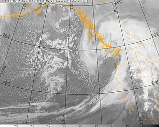
The effects of Hurricane Isabel in Pennsylvania were primarily related to tropical storm force winds across much of the state. Hurricane Isabel formed from a tropical wave on September 6,2003,in the tropical Atlantic Ocean. It moved northwestward,and within an environment of light wind shear and warm waters it steadily strengthened to reach peak winds of 165 mph (266 km/h) on September 11. After fluctuating in intensity for four days,Isabel gradually weakened and made landfall on the Outer Banks of North Carolina with winds of 105 mph (169 km/h) on September 18. It quickly weakened over land and became extratropical over western Pennsylvania the next day.
The Climate of Beaumont,Texas covers the averages and extremes in past weather seen within the city of Beaumont,Texas. The city is within the humid subtropical climate regime,and is within the Piney Woods region of eastern Texas. The area around Beaumont receives the most rainfall in the state:more than 65 inches (1,700 mm) annually. Summers in the area are usually hot and humid,due to the moisture that flows inland off of the Gulf of Mexico. Winters are usually kept mild by the warm gulf waters. Hurricanes also pose a threat to the area. Hurricane Harvey in 2017,Hurricane Rita in 2005,and Hurricane Ike in 2008 were the most recent significant storms to strike.

Hurricane Ike was a powerful tropical cyclone that swept through portions of the Greater Antilles and Northern America in September 2008,wreaking havoc on infrastructure and agriculture,particularly in Cuba and Texas. Ike took a similar track to the 1900 Galveston hurricane. The ninth tropical storm,fifth hurricane,and third major hurricane of the 2008 Atlantic hurricane season,Ike developed from a tropical wave west of Cape Verde on September 1 and strengthened to a peak intensity as a Category 4 hurricane over the open waters of the central Atlantic on September 4 as it tracked westward. Several fluctuations in strength occurred before Ike made landfall on eastern Cuba on September 8. The hurricane weakened prior to continuing into the Gulf of Mexico,but increased its intensity by the time of its final landfall in Galveston,Texas,on September 13 before becoming an extratropical storm on September 14. The remnants of Ike continued to track across the United States and into Canada,causing considerable damage inland,before dissipating on the next day.

Hurricane Ike caused major destruction in Texas with crippling and long-lasting effects,including death,widespread damage,and impacts to the price and availability of oil and gas. Hurricane Ike also had a long-term impact on the U.S. economy. Making landfall over Galveston as a Category 2 hurricane,at 2:10 a.m. CDT on September 13,2008,Hurricane Ike caused extensive damage in Texas,with sustained winds of 110 mph (180 km/h),a 22 ft (6.7 m) storm surge,and widespread coastal flooding.
The March 2010 nor'easter or St. Patrick's Day nor'easter was a powerful nor'easter that impacted the Northeastern United States and Eastern Canada from March 12–16,2010,resulting in at least nine deaths. The slow-moving storm produced over 10 inches (25 cm) of rain in New England,causing widespread flooding of urban and low-lying areas. Winds of up to 70 miles per hour (110 km/h) snapped trees and power lines,resulting in over one million homes and businesses left without electricity. The storm also caused extensive coastal flooding and beach erosion. The nor'easter was the fifth major winter storm to impact the Mid-Atlantic and New England in the 2009–10 North American winter storm season.
Hurricane Irene was a large and destructive tropical cyclone which affected much of the Caribbean and East Coast of the United States during late August 2011. The ninth named storm,first hurricane,and first major hurricane of the 2011 Atlantic hurricane season,Irene originated from a well-defined Atlantic tropical wave that began showing signs of organization east of the Lesser Antilles. Due to development of atmospheric convection and a closed center of circulation,the system was designated as Tropical Storm Irene on August 20,2011. After intensifying,Irene made landfall in St. Croix as a strong tropical storm later that day. Early on August 21,the storm made a second landfall in Puerto Rico. While crossing the island,Irene strengthened into a Category 1 hurricane. The storm paralleled offshore of Hispaniola,continuing to slowly intensify in the process. Shortly before making four landfalls in the Bahamas,Irene peaked as a 120 mph (190 km/h) Category 3 hurricane.
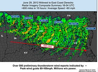
The June 2012 Mid-Atlantic and Midwest derecho was one of the deadliest and most destructive fast-moving severe thunderstorm complexes in North American history. The progressive derecho tracked across a large section of the Midwestern United States and across the central Appalachians into the mid-Atlantic states on the afternoon and evening of June 29,2012,and into the early morning of June 30,2012. It resulted in a total of 22 deaths,millions of power outages across the entire affected region,and a damage total of US$2.9 billion which exceeded that of all other derecho events aside from the August 2020 Midwest derecho. The storm prompted the issuance of four separate severe thunderstorm watches by the Storm Prediction Center. A second storm in the late afternoon caused another watch to be issued across Iowa and Illinois.
Hurricane Sandy was an extremely large and destructive Category 3 Atlantic hurricane which ravaged the Caribbean and the coastal Mid-Atlantic region of the United States in late October 2012. It was the largest Atlantic hurricane on record as measured by diameter,with tropical-storm-force winds spanning 1,150 miles (1,850 km). The storm inflicted nearly $70 billion in damage,and killed 233 people in eight countries,from the Caribbean to Canada. The eighteenth named storm,tenth hurricane,and second major hurricane of the 2012 Atlantic hurricane season,Sandy was a Category 3 storm at its peak intensity when it made landfall in Cuba,though most of the damage it caused was after it became a Category 1-equivalent extratropical cyclone off the coast of the Northeastern United States.

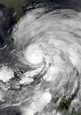
Hurricane Irma was the costliest tropical cyclone in the history of the U.S. state of Florida,before being surpassed by Hurricane Ian in 2022. Irma developed from a tropical wave near the Cape Verde Islands on August 30,2017. The storm quickly became a hurricane on August 31 and then a major hurricane shortly thereafter,but would oscillate in intensity over the next few days. By September 4,Irma resumed strengthening,and became a powerful Category 5 hurricane on the following day. The cyclone then struck Saint Maarten and the British Virgin Islands on September 6 and later crossed Little Inagua in the Bahamas on September 8. Irma briefly weakened to a Category 4 hurricane,but re-intensified into a Category 5 hurricane before making landfall in the Sabana-Camagüey Archipelago of Cuba. After falling to Category 3 status due to land interaction,the storm re-strengthened into a Category 4 hurricane in the Straits of Florida. Irma struck Florida twice on September 10 –the first as a Category 4 at Cudjoe Key and the second on Marco Island as a Category 3. The hurricane weakened significantly over Florida,and was reduced to a tropical storm,before exiting the state into Georgia on September 11.

The March 1–3,2018 nor'easter caused major impacts as well as significant coastal flooding in the Northeastern,Mid-Atlantic and Southeastern United States. It originated as the northernmost low of a stationary front over the Midwest on March 1,which moved eastward into the Northeast later that night. A new low pressure system rapidly formed off the coast on March 2 as it slowly meandered near the coastline. It peaked later that day and brought hurricane-force winds to coastal New England before gradually moving out to sea by March 3. Producing over 2 feet (24 in) of snow in some areas,it was one of the most significant March snowstorms in many areas,particularly in Upstate New York. In other areas,it challenged storm surge records set by other significant storms,such as Hurricane Sandy. It was unofficially named Winter Storm Riley by The Weather Channel.
Hurricane Barry was an asymmetrical Category 1 hurricane that was the wettest tropical cyclone on record in Arkansas and the fourth-wettest in Louisiana. The second tropical or subtropical storm and first hurricane of the 2019 Atlantic hurricane season,Barry originated as a mesoscale convective vortex over southwestern Kansas on July 2. The system eventually emerged into the Gulf of Mexico from the Florida Panhandle on July 10,whereupon the National Hurricane Center (NHC) designated it as a potential tropical cyclone. Early on July 11,the system developed into a tropical depression,and strengthened into a tropical storm later that day. Dry air and wind shear caused most of the convection,or thunderstorms,to be displaced south of the center. Nevertheless,Barry gradually intensified. On July 13,Barry attained its peak intensity as Category 1 hurricane with 1-minute sustained winds of 75 mph (120 km/h) and a minimum central pressure of 993 millibars (29.3 inHg). At 15:00 UTC,Barry made its first landfall at Marsh Island,and another landfall in Intracoastal City,Louisiana,both times as a Category 1 hurricane. Barry quickly weakened after landfall,falling to tropical depression status on July 15. The storm finally degenerated into a remnant low over northern Arkansas on the same day,subsequently opening up into a trough on July 16. The storm's remnants persisted for another few days,while continuing its eastward motion,before being absorbed into another frontal storm to the south of Nova Scotia on July 19.

Hurricane Sally was a destructive and slow-moving Atlantic hurricane that was the first hurricane to make landfall in the U.S. state of Alabama since Ivan in 2004,coincidentally on the same date in the same place. The eighteenth named storm and seventh hurricane of the extremely active 2020 Atlantic hurricane season,Sally developed from an area of disturbed weather which was first monitored over the Bahamas on September 10. The system grew a broad area of low-pressure on September 11,and was designated as a tropical depression late that day. Early the next day,the depression made landfall at Key Biscayne and subsequently strengthened into Tropical Storm Sally that afternoon. Moderate northwesterly shear prevented significant intensification for the first two days,but convection continued to grow towards the center and Sally slowly intensified. On September 14,a center reformation into the center of the convection occurred,and data from a hurricane hunter reconnaissance aircraft showed that Sally had rapidly intensified into a strong Category 1 hurricane. However,an increase in wind shear and upwelling of colder waters halted the intensification and Sally weakened slightly on September 15 before turning slowly northeastward. Despite this increase in wind shear,it unexpectedly re-intensified,reaching Category 2 status early on September 16 before making landfall at peak intensity at 09:45 UTC on September 16,near Gulf Shores,Alabama,with maximum sustained winds of 110 mph (180 km/h) and a minimum central pressure of 965 millibars (28.5 inHg). The storm rapidly weakened after landfall before transitioning into an extratropical low at 12:00 UTC the next day. Sally's remnants lasted for another day as they moved off the coast of the Southeastern United States before being absorbed into another extratropical storm on September 18.


