Crystal City, Missouri

Last updated

Crystal City, Missouri
Mississippi Avenue - Crystal City, MO.jpg
Nickname: 
Crystal Clear town
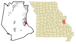
Jefferson County Missouri Incorporated and Unincorporated areas Crystal City Highlighted.svg
Location of Crystal City, Missouri
Coordinates: 38°13′22″N90°22′53″W / 38.22278°N 90.38139°W / 38.22278; -90.38139
Country United States
State Missouri
County Jefferson
Incorporated 1911
Government
   Mayor Mike Osher[ citation needed ]
Area
[1]
  Total4.52 sq mi (11.71 km2)
  Land4.51 sq mi (11.69 km2)
  Water0.01 sq mi (0.02 km2)
Elevation
[2]
440 ft (130 m)
Population
 (2020)
  Total4,740
  Density1,049.83/sq mi (405.31/km2)
Time zone UTC-6 (Central (CST))
  Summer (DST) UTC-5 (CDT)
ZIP code
63019
Area code 636
FIPS code 29-17632 [3]
GNIS feature ID2393684 [2]
Website http://www.crystalcitymo.org
[4]

Crystal City is a city in eastern Jefferson County, Missouri, United States and is a suburb of St. Louis. The population was 4,855 at the 2010 census. [5] It was 4,740 at the 2020 census.

Contents

Crystal City and its neighbor Festus are often collectively known as the "Twin Cities".

History

Crystal City was originally called New Detroit. [6] A post office called Crystal City has been in operation since 1872. [7] In the 1880s, Pittsburgh Plate Glass Company opened a glass manufacturing plant, which is the origin of the city's name. Currently, the PPG plant property remains empty and undeveloped. It was purchased by Wings Enterprises in the mid-2000s with the intentions of constructing an iron ore smelter on the property. In the early 2000s, the state of Missouri forced Doe Run Company to purchase 160 homes in Herculaneum after it was found over 56% of children within a quarter-mile (0.4 km) of the plant had high levels of lead in their blood. [8] This prompted greater concern when Crystal City engaged in discussions over building a $1 billion dollar iron-ore smelter on the lands of the abandoned factory.

Geography

Crystal City is located adjacent to the Mississippi River floodplain to the east and the city of Festus to the west. [9]

According to the United States Census Bureau, the city has a total area of 4.57 square miles (11.84 km2), of which 4.56 square miles (11.81 km2) is land and 0.01 square miles (0.03 km2) is water. [10]

Demographics

Historical population
CensusPop.Note
1880 460
1890 1,104140.0%
1920 2,243
1930 3,05736.3%
1940 3,41711.8%
1950 3,4992.4%
1960 3,6785.1%
1970 3,8986.0%
1980 3,618−7.2%
1990 4,08813.0%
2000 4,2473.9%
2010 4,85514.3%
2020 4,740−2.4%
U.S. Decennial Census [11]

2010 census

As of the census [12] of 2010, there were 4,855 people, 1,894 households, and 1,228 families living in the city. The population density was 1,064.7 inhabitants per square mile (411.1/km2). There were 2,078 housing units at an average density of 455.7 per square mile (175.9/km2). The racial makeup of the city was 93.2% White, 3.7% African American, 0.4% Native American, 0.6% Asian, 0.3% from other races, and 1.9% from two or more races. Hispanic or Latino of any race were 1.0% of the population.

There were 1,894 households, of which 36.0% had children under the age of 18 living with them, 45.9% were married couples living together, 13.7% had a female householder with no husband present, 5.2% had a male householder with no wife present, and 35.2% were non-families. 29.4% of all households were made up of individuals, and 12.3% had someone living alone who was 65 years of age or older. The average household size was 2.47 and the average family size was 3.06.

The median age in the city was 37.1 years. 25.7% of residents were under the age of 18; 7.8% were between the ages of 18 and 24; 25.9% were from 25 to 44; 24.2% were from 45 to 64; and 16.5% were 65 years of age or older. The gender makeup of the city was 47.6% male and 52.4% female.

2000 census

As of the census [3] of 2000, there were 4,247 people, 1,622 households, and 1,111 families living in the city. The population density was 1,136.7 inhabitants per square mile (438.9/km2). There were 1,769 housing units at an average density of 473.5 per square mile (182.8/km2). The racial makeup of the city was 92.11% White, 5.34% African American, 0.26% Native American, 0.52% Asian, 0.07% from other races, and 1.70% from two or more races. Hispanic or Latino of any race were 0.49% of the population.

There were 1,622 households, out of which 32.2% had children under the age of 18 living with them, 51.2% were married couples living together, 13.8% had a female householder with no husband present, and 31.5% were non-families. 28.2% of all households were made up of individuals, and 13.6% had someone living alone who was 65 years of age or older. The average household size was 2.44 and the average family size was 2.97.

In the city, the population was spread out, with 24.0% under the age of 18, 8.5% from 18 to 24, 25.7% from 25 to 44, 21.5% from 45 to 64, and 20.3% who were 65 years of age or older. The median age was 40 years. For every 100 females, there were 87.6 males. For every 100 females age 18 and over, there were 81.1 males.

The median income for a household in the city was $36,117, and the median income for a family was $45,288. Males had a median income of $41,111 versus $23,750 for females. The per capita income for the city was $17,816. About 12.6% of families and 15.2% of the population were below the poverty line, including 21.6% of those under age 18 and 6.3% of those age 65 or over.

Education

Crystal City 47 Public Schools operates one elementary school and Crystal City High School. [13]

The town has a lending library, the Crystal City Public Library. [14]

Notable people

Related Research Articles

<span class="mw-page-title-main">Belton, Missouri</span> City in Missouri, United States

Belton is a city in northwestern Cass County, Missouri, United States. The population was 23,116 at the 2010 census.

<span class="mw-page-title-main">Bunceton, Missouri</span> City in Missouri, United States

Bunceton is a city in Cooper County, Missouri, United States. The population was 354 at the 2010 census.

<span class="mw-page-title-main">Weaubleau, Missouri</span> City in Missouri, United States

Weaubleau is a city in Hickory County, Missouri, United States, founded in 1867. The population was 378 at the 2020 census.

<span class="mw-page-title-main">Levasy, Missouri</span> City in Missouri, United States

Levasy is a city in Jackson County, Missouri, United States. The population was 83 at the 2010 census. It is part of the Kansas City metropolitan area.

<span class="mw-page-title-main">Waco, Missouri</span> City in Missouri, United States

Waco is a city in Jasper County, Missouri, United States. The population was 72 at the 2020 census. It is part of the Joplin, Missouri Metropolitan Statistical Area.

<span class="mw-page-title-main">Kingsville, Missouri</span> City in Missouri, United States

Kingsville is a city in west central Johnson County, Missouri, United States. The population was 245 at the 2020 census.

<span class="mw-page-title-main">Jonesburg, Missouri</span> City in Missouri, United States

Jonesburg is a city in Montgomery County, Missouri, United States. The population was 726 at the 2020 census.

<span class="mw-page-title-main">Lilbourn, Missouri</span> City in Missouri, United States

Lilbourn is a city in New Madrid County, Missouri, United States. The population was 994 at the 2020 census.

<span class="mw-page-title-main">Crystal Lakes, Missouri</span> City in Missouri, United States

Crystal Lakes is a city in western Ray County, Missouri, and part of the Kansas City metropolitan area within the United States. The population was 390 at the 2020 census.

<span class="mw-page-title-main">Wood Heights, Missouri</span> City in Missouri, United States

Wood Heights is a city in western Ray County, Missouri, and part of the Kansas City metropolitan area within the United States. The population was 757 at the 2020 census.

<span class="mw-page-title-main">Naylor, Missouri</span> City in Missouri, United States

Naylor is a city in southeastern Ripley County, Missouri, United States. The population was 440 at the 2020 census.

<span class="mw-page-title-main">Gilliam, Missouri</span> City in Missouri, United States

Gilliam is a city in Saline County, Missouri, United States. The population was 197 at the 2010 census.

<span class="mw-page-title-main">Crystal Lake Park, Missouri</span> City in Missouri, United States

Crystal Lake Park is a Missouri Class 4 city in St. Louis County, Missouri, United States. The population was 508 at the 2020 census.

<span class="mw-page-title-main">Dellwood, Missouri</span> City in Missouri, United States

Dellwood is a city in the north St. Louis County, Missouri, United States. The population was 5,025 at the 2010 census. The center of Dellwood or the city of Dellwood was located at the intersections of West Florissant Ave. and Chambers Road.

<span class="mw-page-title-main">Glen Echo Park, Missouri</span> Village in Missouri, United States

Glen Echo Park is a village in St. Louis County, Missouri, United States. The population was 160 at the 2010 census. The community took its name from the Glen Echo Country Club. Glen Echo Park is set to consolidate with the neighboring city of Normandy on February 8, 2024.

<span class="mw-page-title-main">Oakland, Missouri</span> City in Missouri, United States

Oakland is a city in St. Louis County, Missouri, United States. The population was 1,381 at the 2010 census.

<span class="mw-page-title-main">Twin Oaks, Missouri</span> City in Missouri, United States

Twin Oaks is a 4th class city in St. Louis County, Missouri, United States. The former Village of Twin Oaks changed its status to that of a city by public election in November 2016. The population was 392 at the 2010 census.

<span class="mw-page-title-main">Moscow Mills, Missouri</span> City in Missouri, United States

Moscow Mills is a city in Lincoln County, Missouri, United States. The population was 2,509 at the 2010 census.

<span class="mw-page-title-main">Montgomery City, Missouri</span> City in Missouri, United States

Montgomery City is a city in and the county seat of Montgomery County, Missouri, United States. The population was 2,811 at the 2020 census.

<span class="mw-page-title-main">Crystal, North Dakota</span> City in North Dakota, United States

Crystal is a city in Pembina County, North Dakota, United States. The population was 116 at the 2020 census. Crystal was founded in 1879.

References

  1. "ArcGIS REST Services Directory". United States Census Bureau. Retrieved August 28, 2022.
  2. 1 2 U.S. Geological Survey Geographic Names Information System: Crystal City, Missouri
  3. 1 2 "U.S. Census website". United States Census Bureau . Retrieved January 31, 2008.
  4. Crystal City, Missouri (City-Data.com)
  5. U.S. Census Bureau - Crystal City, U.S. Census Bureau
  6. "Jefferson County Place Names, 1928–1945 (archived)". The State Historical Society of Missouri. Archived from the original on June 24, 2016. Retrieved October 19, 2016.{{cite web}}: CS1 maint: bot: original URL status unknown (link)
  7. "Post Offices". Jim Forte Postal History. Archived from the original on October 19, 2016. Retrieved October 19, 2016.
  8. Garrison, Chad (January 16, 2008). "Smelterville". Riverfront times. Riverfront Times. Retrieved September 9, 2018.
  9. Missouri Atlas & Gazetteer, DeLorme, 1st ed. 1998, p.49 ISBN   0899332242
  10. "US Gazetteer files 2010". United States Census Bureau. Archived from the original on January 25, 2012. Retrieved July 8, 2012.
  11. "Census of Population and Housing". Census.gov. Retrieved June 4, 2015.
  12. "U.S. Census website". United States Census Bureau . Retrieved July 8, 2012.
  13. "Crystal City 47 School District". Greatschools. Retrieved March 25, 2018.
  14. "Missouri Public Libraries". PublicLibraries.com. Archived from the original on June 10, 2017. Retrieved March 25, 2018.