Goldman is an unincorporated community in Jefferson County, Missouri, United States, approximately 25 miles south of St. Louis, and five miles north of the county courthouse at Hillsboro. Goldman is located on Old Lemay Ferry Road, an old trade route connecting Hillsboro and St. Louis.
Fletcher is an unincorporated community in western Jefferson County, Missouri, United States.

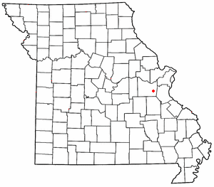
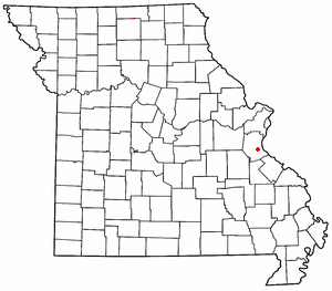
Hematite is an unincorporated community in eastern Jefferson County, Missouri, United States. It is located on Missouri Route P approximately seven miles northeast of De Soto.

Morse Mill is an unincorporated community in western Jefferson County, Missouri, United States. It is located approximately five miles northwest of Hillsboro along Missouri Route B. The community and mill were located along Big River.

Valles Mines is an unincorporated community in southern Jefferson County, Missouri, United States. It is located approximately seven miles south of De Soto. It is located on Missouri Route V less than one mile west of U.S. Route 67. Joachim Creek flows past the north side of the community. The ZIP Code for Valles Mines is 63087.
Lonedell is an unincorporated community in southeastern Franklin County, Missouri, United States. It is at the intersection of Route 30 and routes N and FF and approximately eight miles east of St. Clair. The Little Meramac River flows just south of the community.

Luebbering is an unincorporated community in eastern Franklin County, Missouri, United States. It is located on Missouri Route FF, approximately ten miles southeast of St. Clair and about 2.5 miles south of Lonedell.
Boles is an unincorporated community in northern Franklin County, in the U.S. state of Missouri.
Calvey Creek is a stream in Franklin and Jefferson counties in the U.S. state of Missouri. It is a tributary to the Meramec River.
Mount Hope (also spelled is an unincorporated community in southeastern Franklin County, in the U.S. state of Missouri.
Winch Creek is a stream in eastern Franklin County in the U.S. state of Missouri. Winch Creek is a tributary to the Meramec River.
Danby is an unincorporated community in southeast Jefferson County, in the U.S. state of Missouri.
Flucom is an unincorporated community in southern Jefferson County, in the U.S. state of Missouri. The community is located on Plattin Creek approximately eight miles south of Festus. US Route 67 passes about two miles to the west.
Isle du Bois Creek is a stream in Jefferson and Ste. Genevieve counties of the U.S. state of Missouri. It is a tributary of the Mississippi River.
Jarvis is an unincorporated community in Jefferson County, in the U.S. state of Missouri. Jarvis is located approximately 1.5 miles northwest of Mapaville and 2.5 miles southeast of Goldman.
Jones Creek is a stream in western Jefferson County, Missouri. It is a tributary of Big River.
Melzo is an unincorporated community in southern Jefferson County, in the U.S. state of Missouri. The community is located on Missouri Route E just north of the Jefferson-St. Francois county line. DeSoto is eight miles to the north and Bone Terre is approximately six miles to the south.
Oermann is an unincorporated community in western Jefferson County, in the U.S. state of Missouri. The community is located on Missouri Route 30 approximately two miles northeast of Grubville and two miles southwest of Dittmer.
Plattin is an unincorporated community in southeast Jefferson County, in the U.S. state of Missouri.
Selma is an unincorporated community in southeastern Jefferson County, in the U.S. state of Missouri. The community is located on the west side of US Route 61 approximately six miles southeast of Festus. The Mississippi River floodplain lies two miles to the east.

