Murphy, Missouri

Last updated

Murphy, Missouri
Jefferson County Missouri Incorporated and Unincorporated areas Murphy Highlighted.svg
Location of Murphy, Missouri
Coordinates: 38°29′31″N90°29′09″W / 38.49194°N 90.48583°W / 38.49194; -90.48583
Country United States
State Missouri
County Jefferson
Area
[1]
  Total3.90 sq mi (10.10 km2)
  Land3.86 sq mi (10.01 km2)
  Water0.04 sq mi (0.10 km2)
Elevation
[2]
538 ft (164 m)
Population
 (2020)
  Total8,425
  Density2,180.95/sq mi (841.99/km2)
Time zone UTC-6 (Central (CST))
  Summer (DST) UTC-5 (CDT)
ZIP Code
63026
FIPS code 29-50834 [3]
GNIS feature ID2393142 [2]

Murphy is a census-designated place (CDP) in Jefferson County, Missouri, United States. The population was 8,690 at the 2010 census, [4] down from 9,048 in 2000.

Contents

History

A post office called Murphy was established in 1894, and remained in operation until 1906. [5] The community has the name of the local Murphy family. [6]

Geography

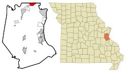
Murphy is located in northern Jefferson County with its northern border following the St. Louis County line. Missouri Route 30 passes through the community, leading northeast 19 miles (31 km) to downtown St. Louis and southwest 35 miles (56 km) to St. Clair.

According to the United States Census Bureau, the CDP has a total area of 4.0 square miles (10.3 km2), of which 0.04 square miles (0.1 km2), or 0.95%, are water. [4]

Demographics

Historical population
CensusPop.Note
2020 8,425
U.S. Decennial Census [7]

As of the census [3] of 2000, there were 9,048 people, 3,463 households, and 2,489 families residing in the CDP. The population density was 2,281.9 inhabitants per square mile (881.0/km2). There were 3,613 housing units at an average density of 911.2 per square mile (351.8/km2). The racial makeup of the CDP was 97.75% White, 0.22% African American, 0.20% Native American, 0.43% Asian, 0.33% from other races, and 1.07% from two or more races. Hispanic or Latino of any race were 1.07% of the population.

There were 3,463 households, out of which 35.4% had children under the age of 18 living with them, 55.1% were married couples living together, 11.9% had a female householder with no husband present, and 28.1% were non-families. 22.1% of all households were made up of individuals, and 7.0% had someone living alone who was 65 years of age or older. The average household size was 2.61 and the average family size was 3.05.

In the CDP, the population was spread out, with 26.5% under the age of 18, 8.8% from 18 to 24, 32.6% from 25 to 44, 22.3% from 45 to 64, and 9.7% who were 65 years of age or older. The median age was 35 years. For every 100 females, there were 96.1 males. For every 100 females age 18 and over, there were 93.6 males.

The median income for a household in the CDP was $42,430, and the median income for a family was $48,060. Males had a median income of $35,373 versus $25,630 for females. The per capita income for the CDP was $20,374. About 4.5% of families and 5.8% of the population were below the poverty line, including 8.2% of those under age 18 and 6.0% of those age 65 or over.

Related Research Articles

<span class="mw-page-title-main">Forestdale, Alabama</span> Unincorporated community in Alabama, United States

Forestdale is an unincorporated community and census-designated place (CDP) in Jefferson County, Alabama, United States. It is north of the Birmingham city neighborhood of Ensley. At the 2020 census, the population was 10,409.

<span class="mw-page-title-main">Blackhawk-Camino Tassajara, California</span> Former census-designated place in California, United States

Blackhawk-Camino Tassajara is a former census-designated place (CDP) in Contra Costa County, California, near the town of Danville. The unincorporated area consisted of the Blackhawk planned community and the surrounding Camino Tassajara area. At the 2000 census, the CDP's population was 10,048. The CDP was split between Blackhawk and Camino Tassajara before the 2010 census.

<span class="mw-page-title-main">Hidden Meadows, California</span> Census designated place in California, United States

Hidden Meadows is a census-designated place (CDP) near Escondido in San Diego County, California. The population was 3,485 at the 2010 census, up from 3,463 at the 2000 census.

<span class="mw-page-title-main">Lake Asbury, Florida</span> Census-designated place in Florida, United States

Lake Asbury is an unincorporated community and census-designated place (CDP) in Clay County, Florida, United States. The population was 8,700 at the 2010 census, which calls it Asbury Lake.

<span class="mw-page-title-main">Gray Summit, Missouri</span> Census-designated place in Missouri, United States

Gray Summit is an unincorporated community and census-designated place (CDP) in Franklin County, Missouri, United States. The population was 2,701 at the 2010 census. Also called "Gray's Summit", it was founded by Daniel Gray of New York, who built a hotel here in 1845. It is located on Missouri Route 100 just north of Interstate 44.

<span class="mw-page-title-main">Villa Ridge, Missouri</span> Census-designated place in Missouri, United States

Villa Ridge is an unincorporated community and census-designated place (CDP) in Franklin County, Missouri, United States. The population was 2,636 at the 2010 census, up from 2,417 at the 2000 census.

<span class="mw-page-title-main">Barnhart, Missouri</span> CDP in Missouri, United States

Barnhart is a census-designated place (CDP) in Jefferson County, Missouri, United States. Barnhart is also a suburb of St. Louis.

<span class="mw-page-title-main">Cedar Hill, Missouri</span> Census-designated place in Missouri, United States

Cedar Hill is an unincorporated community and census-designated place (CDP) in northwest Jefferson County, Missouri, United States. The population was 1,721 at the 2010 census.

<span class="mw-page-title-main">High Ridge, Missouri</span> Census-designated place in Missouri, United States

High Ridge is an unincorporated community and census-designated place (CDP) in Jefferson County, Missouri, United States. The population was 4,305 at the 2010 census. At 927 feet (283 m) above sea level, High Ridge is the second-highest point in Jefferson County, second only to Sun Ridge, north of Hillsboro, according to data from the House Springs/Hillsboro 7.5 minute topographic quadrangles. The Beaumont Scout Reservation, a property of the Greater St. Louis Area Council, Boy Scouts of America, is 4 miles (6 km) north of High Ridge.

<span class="mw-page-title-main">Horine, Missouri</span> Census-designated place in Missouri, United States

Horine is an unincorporated community and census-designated place (CDP) in Jefferson County, Missouri, United States. The population was 821 at the 2010 census, down from 923 in 2000.

<span class="mw-page-title-main">Imperial, Missouri</span> Census-designated place in Missouri, United States

Imperial is a census-designated place (CDP) in Jefferson County, Missouri, United States, and is a suburb of St. Louis. The population was 4,947 at the 2020 census. Imperial was originally known as West Kimmswick, the historic Catholic church of St. John’s in Imperial, became an independent parish in 1869.

<span class="mw-page-title-main">Oakville, Missouri</span> CDP in Missouri, United States

Oakville is a census-designated place (CDP) in south St. Louis County, Missouri, United States. The population was 36,301 at the 2020 census. Oakville is 18 miles south of the city of St. Louis and borders the Mississippi and Meramec rivers; the area is part of "South County".

<span class="mw-page-title-main">Springdale, New Jersey</span> Populated place in Camden County, New Jersey, US

Springdale is an unincorporated community and census-designated place (CDP) located within Cherry Hill Township, in Camden County, in the U.S. state of New Jersey. As of the 2010 United States Census, the section population was 14,518.

<span class="mw-page-title-main">Laurel Lake, New Jersey</span> Populated place in Cumberland County, New Jersey, US

Laurel Lake is an unincorporated community and census-designated place (CDP) located within Commercial Township, in Cumberland County, in the U.S. state of New Jersey. It is part of the Vineland-Millville-Bridgeton Primary Metropolitan Statistical Area for statistical purposes. As of the 2010 United States Census, the CDP's population was 2,989.

<span class="mw-page-title-main">Boles Acres, New Mexico</span> CDP in New Mexico, United States

Boles Acres is a census-designated place (CDP) in Otero County, New Mexico, United States. The population was 1,638 at the 2010 census.

Redwood is a hamlet and census-designated place (CDP) in Jefferson County, New York, United States. As of the 2010 census, the population was 605.

<span class="mw-page-title-main">Shelter Island Heights, New York</span> Hamlet and census-designated place in New York, United States

Shelter Island Heights is a hamlet and census-designated place (CDP) located in the Town of Shelter Island, Suffolk County, New York, United States. It is located on the north side of the island of Shelter Island, surrounding the village of Dering Harbor. The population was 1,048 at the 2010 census.

Locustdale is a census-designated place (CDP) that is located on the border of Columbia and Schuylkill counties, Pennsylvania, United States. It is part of Northeastern Pennsylvania.

<span class="mw-page-title-main">Loch Lomond, Virginia</span> Census-designated place in Virginia, United States

Loch Lomond is a census-designated place (CDP) in Prince William County, Virginia, United States. The population was 3,701 at the 2010 census. It is named after a loch in northern Scotland, Loch Lomond.

<span class="mw-page-title-main">Jefferson Valley, New York</span> Census-designated place in New York, United States

Jefferson Valley-Yorktown, commonly known as Jefferson Valley, is a census-designated place (CDP) located in the town of Yorktown in Westchester County, New York, United States. The population was 14,142 at the 2010 census. It is a hot spot for local shoppers, due to its Jefferson Valley Mall.

References

  1. "ArcGIS REST Services Directory". United States Census Bureau. Retrieved August 28, 2022.
  2. 1 2 U.S. Geological Survey Geographic Names Information System: Murphy, Missouri
  3. 1 2 "U.S. Census website". United States Census Bureau . Retrieved January 31, 2008.
  4. 1 2 "Geographic Identifiers: 2010 Census Summary File 1 (G001): Murphy CDP, Missouri". American Factfinder. U.S. Census Bureau. Archived from the original on February 13, 2020. Retrieved August 20, 2018.
  5. "Post Offices". Jim Forte Postal History. Retrieved October 19, 2016.
  6. "Jefferson County Place Names, 1928–1945 (archived)". The State Historical Society of Missouri. Archived from the original on June 24, 2016. Retrieved October 19, 2016.{{cite web}}: CS1 maint: bot: original URL status unknown (link)
  7. "Census of Population and Housing". Census.gov. Retrieved June 4, 2016.