Scotsdale, Missouri

Last updated

Scotsdale, Missouri
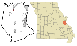
Jefferson County Missouri Incorporated and Unincorporated areas Scotsdale Highlighted.svg
Location of Scotsdale, Missouri
Coordinates: 38°23′10″N90°35′38″W / 38.38611°N 90.59389°W / 38.38611; -90.59389
Country United States
State Missouri
County Jefferson
Area
[1]
  Total0.58 sq mi (1.50 km2)
  Land0.58 sq mi (1.50 km2)
  Water0.00 sq mi (0.00 km2)
Elevation
[2]
581 ft (177 m)
Population
 (2020)
  Total194
  Density334.48/sq mi (129.15/km2)
Time zone UTC-6 (Central (CST))
  Summer (DST) UTC-5 (CDT)
FIPS code 29-66337 [3]
GNIS feature ID2396909 [2]

Scotsdale is a village in Jefferson County, Missouri, United States. The population was 222 at the 2010 census.

Contents

Geography

Scotsdale is located at 38°24′4″N90°35′18″W / 38.40111°N 90.58833°W / 38.40111; -90.58833 (38.401092, -90.588374). [4] According to the United States Census Bureau, the village has a total area of 0.74 square miles (1.92 km2), all land. [5]

Demographics

Historical population
CensusPop.Note
1980 183
1990 1935.5%
2000 2119.3%
2010 2225.2%
2020 194−12.6%
U.S. Decennial Census [6]

2010 census

As of the census [7] of 2010, there were 222 people, 81 households, and 63 families living in the village. The population density was 300.0 inhabitants per square mile (115.8/km2). There were 85 housing units at an average density of 114.9 per square mile (44.4/km2). The racial makeup of the village was 99.5% White and 0.5% from two or more races. Hispanic or Latino of any race were 0.5% of the population.

There were 81 households, of which 38.3% had children under the age of 18 living with them, 65.4% were married couples living together, 11.1% had a female householder with no husband present, 1.2% had a male householder with no wife present, and 22.2% were non-families. 17.3% of all households were made up of individuals, and 2.5% had someone living alone who was 65 years of age or older. The average household size was 2.74 and the average family size was 3.11.

The median age in the village was 42.5 years. 22.1% of residents were under the age of 18; 10.8% were between the ages of 18 and 24; 20.8% were from 25 to 44; 34.3% were from 45 to 64; and 12.2% were 65 years of age or older. The gender makeup of the village was 50.9% male and 49.1% female.

2000 census

As of the census [3] of 2000, there were 211 people, 66 households, and 59 families living in the town. The population density was 262.4 inhabitants per square mile (101.3/km2). There were 68 housing units at an average density of 84.6 per square mile (32.7/km2). The racial makeup of the town was 98.58% White, 0.47% African American, 0.47% Asian, and 0.47% from two or more races.

There were 66 households, out of which 47.0% had children under the age of 18 living with them, 71.2% were married couples living together, 13.6% had a female householder with no husband present, and 10.6% were non-families. 7.6% of all households were made up of individuals, and none had someone living alone who was 65 years of age or older. The average household size was 3.20 and the average family size was 3.29.

In the town the population was spread out, with 34.1% under the age of 18, 7.1% from 18 to 24, 27.0% from 25 to 44, 26.1% from 45 to 64, and 5.7% who were 65 years of age or older. The median age was 36 years. For every 100 females, there were 99.1 males. For every 100 females age 18 and over, there were 90.4 males.

The median income for a household in the town was $53,750, and the median income for a family was $51,250. Males had a median income of $40,625 versus $25,417 for females. The per capita income for the town was $16,304. About 7.1% of families and 14.0% of the population were below the poverty line, including 20.2% of those under the age of eighteen and none of those 65 or over.
Related Research Articles

<span class="mw-page-title-main">Wabasso Beach, Florida</span> CDP in Florida, United States

Wabasso Beach is a census-designated place (CDP) in Indian River County, Florida, United States. The population was 1,853 at the 2010 census, an increase of 72.4% since 2000. It is part of the Sebastian–Vero Beach Metropolitan Statistical Area.

<span class="mw-page-title-main">Cleveland, Illinois</span> Village in Illinois, United States

Cleveland is a village in Henry County, Illinois, United States. The population was 188 at the 2010 census, down from 253 in 2000.

Pistakee Highlands is a census-designated place (CDP) in McHenry County, Illinois, United States. It consists primarily of an unincorporated area of McHenry County adjoining Pistakee Bay, within the McHenry post office, and is located just northeast of Johnsburg. Per the 2020 census, the population was 3,237.

<span class="mw-page-title-main">Brandon Township, Michigan</span> Charter township in Michigan, United States

Brandon Charter Township is a charter township of Oakland County in the U.S. state of Michigan. The population was 15,175 at the 2010 census.

<span class="mw-page-title-main">Rives, Missouri</span> Village in Missouri, United States

Rives is a town in Dunklin County, Missouri, United States. The population was 63 at the 2010 census.

<span class="mw-page-title-main">Mackenzie, Missouri</span> Village in Missouri, United States

Mackenzie is an unincorporated community in St. Louis County, Missouri, United States. The population was 134 at the 2010 census.

<span class="mw-page-title-main">Velda Village Hills, Missouri</span> City in Missouri, United States

Velda Village Hills is a city in northeastern St. Louis County, Missouri, United States. The population was 1,055 at the 2010 census.

<span class="mw-page-title-main">Vinita Terrace, Missouri</span> Former Village in Missouri, United States

Vinita Terrace was a village in St. Louis County, Missouri, United States. The population was 277 at the 2010 census.

<span class="mw-page-title-main">Hanley Hills, Missouri</span> Village in Missouri, United States

Hanley Hills is a village in St. Louis County, Missouri, United States. The population was 2,101 at the 2010 census.

<span class="mw-page-title-main">Munnsville, New York</span> Village in New York, United States

Munnsville is a village located in the Town of Stockbridge in Madison County, New York, United States. The population was 474 at the 2010 census. The village is named for an early settler, Asa Munn, and located on New York State Route 46.

<span class="mw-page-title-main">Cuyahoga Heights, Ohio</span> Village in Ohio, United States

Cuyahoga Heights is a village in Cuyahoga County, Ohio, United States. The population was 573 at the 2020 census. A suburb of Cleveland, it is a part of the Cleveland metropolitan area.

<span class="mw-page-title-main">Waite Hill, Ohio</span> Village in Ohio, United States

Waite Hill is a village in Lake County, Ohio, United States and a rural suburb of Cleveland. The population was 543 at the 2020 census.

<span class="mw-page-title-main">Walbridge, Ohio</span> Village in Ohio, United States

Walbridge is a village in Wood County, Ohio, United States, within the Toledo metropolitan area. The population was 3,011 at the 2020 census.

<span class="mw-page-title-main">Bayview, Texas</span> Town in Texas, United States

Bayview is a town in Cameron County, Texas, United States. The population was 383 at the 2010 census. It is part of the Brownsville–Harlingen–Raymondville and the Matamoros–Brownsville metropolitan areas.

<span class="mw-page-title-main">Fairwater, Wisconsin</span> Village in Wisconsin, United States

Fairwater is a village in Fond du Lac County, Wisconsin, United States. The population was 371 at the 2010 census. The town of Metomen surrounds the village.

<span class="mw-page-title-main">Blue River, Wisconsin</span> Village in Wisconsin, United States

Blue River is a village in Grant County, Wisconsin, United States. The population was 434 at the 2010 census.

<span class="mw-page-title-main">Avoca, Wisconsin</span> Village in Wisconsin, United States

Avoca is a village in Iowa County, Wisconsin, United States. The population was 637 at the 2010 census. It is part of the Madison Metropolitan Statistical Area. It is named after Avoca in Ireland.

<span class="mw-page-title-main">Exeland, Wisconsin</span> Village in Wisconsin, United States

Exeland is a village in Sawyer County, Wisconsin, United States. The population was 229 at the 2020 census.

<span class="mw-page-title-main">La Farge, Wisconsin</span> Village in Wisconsin, United States

La Farge is a village along the Kickapoo River in Vernon County, Wisconsin, United States. Its population was 730 at the 2020 census.

<span class="mw-page-title-main">Readstown, Wisconsin</span> Village in Wisconsin, United States

Readstown is a village in Vernon County, Wisconsin, United States. The population was 376 at the 2020 census.

References

  1. "ArcGIS REST Services Directory". United States Census Bureau. Retrieved August 28, 2022.
  2. 1 2 U.S. Geological Survey Geographic Names Information System: Scotsdale, Missouri
  3. 1 2 "U.S. Census website". United States Census Bureau . Retrieved January 31, 2008.
  4. "US Gazetteer files: 2010, 2000, and 1990". United States Census Bureau. February 12, 2011. Retrieved April 23, 2011.
  5. "US Gazetteer files 2010". United States Census Bureau. Archived from the original on July 2, 2012. Retrieved July 8, 2012.
  6. "Census of Population and Housing". Census.gov. Retrieved June 4, 2015.
  7. "U.S. Census website". United States Census Bureau . Retrieved July 8, 2012.