Big River (Missouri)

Last updated
Big River
Cedar Hill Dam on Big River in Missouri.JPG
Dam at Cedar Hill, Missouri, on the Big River
USA Missouri relief location map.svg
Red pog.svg
Location of Big River Mouth
Usa edcp relief location map.png
Red pog.svg
Big River (Missouri) (the United States)
EtymologyFrench: Grande Rivière
Location
CountryUnited States
StateMissouri
Cities Caledonia, Irondale, Park Hills, Bonne Terre, Byrnes Mill
Physical characteristics
Source 
  location Iron County, Missouri, United States
  coordinates 37°41′18″N90°57′58″W / 37.6883801°N 90.9662409°W / 37.6883801; -90.9662409 [1]
  elevation1,318 ft (402 m) [2]
Mouth Meramec River
  location
United States
  coordinates
38°28′18″N90°37′05″W / 38.47172°N 90.61818°W / 38.47172; -90.61818 [1]
  elevation
410 ft (120 m)
Length145 mi (233 km)
Basin size955 sq mi (2,470 km2)
Discharge 
  location Byrnesville
  average862 cu/ft. per sec. [3]
Basin features
Tributaries 
  left Brock Creek, Clear Creek, Furnace Creek, Hopewell Creek, Blay Creek, Cabanne Course, Bear Creek, Three Hill Creek, Maddin Creek, Mineral Fork, Ditch Creek, Maupin Creek, Jones Creek, Skullbones Creek
  right Sam Branch, Smith Branch, Janes Creek, Dent Branch, Cedar Creek, Mill Creek, Dry Creek (Washington County), Hayden Creek, Eaton Branch, Flat River, Cedar Run, Pike Run, Coonville Creek, Bee Run, Perkins Creek, Dry Creek (Jefferson County), Belews Creek, Heads Creek

The Big River is a tributary of the Meramec River in east-central Missouri. The river rises in western Iron County near the summit of Johnson Mountain just north of Missouri Route 32 and approximately 3.5 miles southeast of the community of Enough. [2] It flows through Washington, Saint Francois, and Jefferson counties. It forms part of the boundary between Jefferson and Saint Francois counties and also part of the boundary between Jefferson and Washington counties. It empties into the Meramec River opposite Eureka where the Meramec forms the border between Jefferson and Saint Louis counties. The river flows through Washington State Park, St. Francois State Park, and the Lead Belt mining district. The elevation of the river at its source is approximately 1,300 feet (400 m) above sea level and at its mouth about 400 feet (120 m). The length of the river is approximately 145 miles (233 km), [4] while the airline distance between source and mouth is about 56 miles (90 km). Its watershed area is 955 square miles (2,470 km2).

Contents

The river flows through or near the communities of Belgrade, Irondale, Park Hills, Bonne Terre, Morse Mill, Cedar Hill, and Byrnes Mill.

Tributaries of the Big River include Flat River, Belews Creek, Turkey Creek, Mill Creek, Mineral Fork, Calico Creek, Heads Creek, Terre Bleue Creek, Ditch Creek, and Jones Creek.

Character of the river

Like many other Ozark streams, the Big River has entrenched meanders; its valley is typically about half a mile wide, sometimes much narrower, and the valley is usually from 150 to 400 feet (46 to 122 m) deep. This indicates that this river formed on a plain near sea level, which give the river its meandering nature, and then was subsequently uplifted, causing entrenchment.
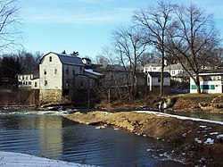
About 83 miles (134 km) are navigable; however, the remains of five small mill dams makes portage necessary, due to drops of several feet or high turbulence. Otherwise, the river is gentle for canoeing, with a Class I difficulty rating. Public parks are adjacent to most of these dams, and are popular fishing spots. Due to steady infeed of springwater, this river is navigable in all seasons.

Major pollution sources near Park Hills are due to historic mining activities, which including erosion from mine tailings piles and leaking mine dams.

Major gamefish commonly found in the river include largemouth bass, smallmouth bass, spotted bass, rock bass, longear sunfish, bluegill, channel catfish, flathead catfish, and redhorse suckers.

History

The name "Big River" is a translation of the French Grande Rivière. [5]

According to the National Weather Service, the maximum flood stage of the Big River at Byrnes Mill occurred on August 21, 1915, and was 30.20 feet (9.20 m), with a flow of roughly 80,000 cubic feet (2,300 m3) per second. Flood stage at Byrnes Mill is 16 feet (4.9 m). The lowest flow measured, 25 cubic feet (0.71 m3) per second, was recorded on August 30, 1936. The average annual discharge here is 862 cubic feet (24.4 m3) per second. August is the month with the lowest average flow, while April has the highest average flow.

See also

Related Research Articles

<span class="mw-page-title-main">White River (Arkansas–Missouri)</span> River in the US

The White River is a 722-mile (1,162 km) river that flows through the U.S. states of Arkansas and Missouri. Originating in the Boston Mountains of northwest Arkansas, it arcs northwards through southern Missouri before turning back into Arkansas, flowing southeast to its mouth at the Mississippi River.

<span class="mw-page-title-main">Meramec River</span> Stream in the American state of Missouri

The Meramec River, sometimes spelled Maramec River, is one of the longest free-flowing waterways in the U.S. state of Missouri, draining 3,980 square miles (10,300 km2) while wandering 218 miles (351 km) from headwaters southeast of Salem to where it empties into the Mississippi River near St. Louis at Arnold and Oakville. The Meramec watershed covers six Missouri Ozark Highland counties—Dent, Phelps, Crawford, Franklin, Jefferson, and St. Louis—and portions of eight others—Maries, Gasconade, Iron, Washington, Reynolds, St. Francois, Ste. Genevieve, and Texas. Between its source and its mouth, it falls 1,025 feet (312 m). Year-round navigability begins above Maramec Spring, just south of St. James. The Meramec's size increases at the confluence of the Dry Fork, and its navigability continues until the river enters the Mississippi at Arnold, Missouri.

<span class="mw-page-title-main">Tuolumne River</span> River from Yosemite to the San Joaquin Valley, California

The Tuolumne River flows for 149 miles (240 km) through Central California, from the high Sierra Nevada to join the San Joaquin River in the Central Valley. Originating at over 8,000 feet (2,400 m) above sea level in Yosemite National Park, the Tuolumne drains a rugged watershed of 1,958 square miles (5,070 km2), carving a series of canyons through the western slope of the Sierra. While the upper Tuolumne is a fast-flowing mountain stream, the lower river crosses a broad, fertile and extensively cultivated alluvial plain. Like most other central California rivers, the Tuolumne is dammed multiple times for irrigation and the generation of hydroelectricity.

<span class="mw-page-title-main">Dolores River</span> River in Colorado and Utah in the United States

The Dolores River is a tributary of the Colorado River, approximately 241 miles (388 km) long, in the U.S. states of Colorado and Utah. The river drains a rugged and arid region of the Colorado Plateau west of the San Juan Mountains. Its name derives from the Spanish El Rio de Nuestra Señora de Dolores, River of Our Lady of Sorrows. The river was explored and possibly named by Juan Maria Antonio Rivera during a 1765 expedition from Santa Fe.

<span class="mw-page-title-main">Salt River (Arizona)</span> River in Gila and Maricopa counties in Arizona, United States

The Salt River is a river in Gila and Maricopa counties in Arizona, United States, that is the largest tributary of the Gila River. The river is about 200 miles (320 km) long. Its drainage basin is about 13,700 square miles (35,000 km2) large. The longest of the Salt River's many tributaries is the 195-mile (314 km) Verde River. The Salt's headwaters tributaries, the Black River and East Fork, increase the river's total length to about 300 miles (480 km). The name Salt River comes from the fact that the river flows over large salt deposits shortly after the merging of the White and Black Rivers.

<span class="mw-page-title-main">Jefferson River</span> River in Montana, United States

The Jefferson River is a tributary of the Missouri River, approximately 83 miles (134 km) long, in the U.S. state of Montana. The Jefferson River and the Madison River form the official beginning of the Missouri at Missouri Headwaters State Park near Three Forks. It is joined 0.6 miles (1.0 km) downstream (northeast) by the Gallatin.

<span class="mw-page-title-main">Souris River</span> River in central North America

The Souris River or Mouse River is a river in central North America. Approximately 435 miles (700 km) in length, it drains about 23,600 square miles (61,100 km2) in Canada and the United States.

<span class="mw-page-title-main">Kentucky River</span> River in Kentucky, United States

The Kentucky River is a tributary of the Ohio River, 260 miles (418 km) long, in the U.S. Commonwealth of Kentucky. The river and its tributaries drain much of the central region of the state, with its upper course passing through the coal-mining regions of the Cumberland Mountains, and its lower course passing through the Bluegrass region in the north central part of the state. Its watershed encompasses about 7,000 square miles (18,000 km2). It supplies drinking water to about one-sixth of the population of the Commonwealth of Kentucky.

<span class="mw-page-title-main">Huron River</span> River in Michigan, United States

The Huron River is a 130-mile-long (210 km) river in southeastern Michigan, rising out of the Huron Swamp in Springfield Township in northern Oakland County and flowing into Lake Erie, as it forms the boundary between present-day Wayne and Monroe counties. Thirteen parks, game areas, and recreation areas are associated with the river, which passes through the cities of Dexter, Ann Arbor, Ypsilanti, Belleville, Flat Rock and Rockwood that were developed along its banks.

<span class="mw-page-title-main">Current River (Ozarks)</span> River in the U.S. state of Missouri

The Current River forms in the southeastern portion of the Ozarks of Missouri and becomes a 7th order stream as it flows southeasterly out of the Ozarks into northeastern Arkansas where it becomes a tributary of the Black River, which is a tributary of the White River, a tributary of the Mississippi River. The Current River is approximately 184 miles (296 km) long and drains about 2,641 square miles (6,840 km2) of land mostly in Missouri and a small portion of land in northeastern Arkansas. The headwaters of the Current River are nearly 900 feet (270 m) above sea level, while the mouth of the river lies around 280 feet (85 m) above sea level. The basin drains a rural area that is dominated by karst topography, underlain by dolomite and sandstone bedrock with a small area of igneous rock southeast of Eminence, Missouri. The annual daily mean discharge of the river near Doniphan, Missouri is 2,815 cubic feet (79.7 m3) per second. In 1964, over 134 mi (160 km) of the upper course of the river and its tributaries were federally protected as the Ozark National Scenic Riverways, the first national park in America to protect a river system.

<span class="mw-page-title-main">Noonday Creek</span>

Noonday Creek is a 20.2-mile-long (32.5 km) stream in Cobb and Cherokee counties in the U.S. state of Georgia. The stream begins near Kennesaw Mountain and ends at Lake Allatoona.

The Bourbeuse River is a river located in east-central Missouri, in the Ozarks region, and is one of two major tributaries of the Meramec River, the other being the Big River. The Bourbeuse flows to the northeast from its source near the locale of Dillon just northeast of Rolla in Phelps County, through Maries, Gasconade, Crawford, and Franklin counties, where it discharges into the Meramec River near Moselle. The elevation of the river at its source is approximately 1,140 feet (350 m) above sea level and at its mouth about 463 feet (141 m). The total length of the river is 154 miles (248 km), while the airline distance between source and mouth is 53 miles (85 km). The watershed area is 842.9 square miles (2,183 km2).

<span class="mw-page-title-main">Spring River (Missouri)</span> River in the United States

The Spring River is a 129-mile-long (208 km) waterway located in southwestern Missouri, southeastern Kansas, and northeastern Oklahoma.

<span class="mw-page-title-main">Kaweah River</span> River in the United States of America

The Kaweah River is a river draining the southern Sierra Nevada in Tulare County, California in the United States. Fed primarily by high elevation snowmelt along the Great Western Divide, the Kaweah begins as four forks in Sequoia National Park, where the watershed is noted for its alpine scenery and its dense concentrations of giant sequoias, the largest trees on Earth. It then flows in a southwest direction to Lake Kaweah – the only major reservoir on the river – and into the San Joaquin Valley, where it diverges into multiple channels across an alluvial plain around Visalia. With its Middle Fork headwaters starting at almost 13,000 feet (4,000 m) above sea level, the river has a vertical drop of nearly two and a half miles (4.0 km) on its short run to the San Joaquin Valley, making it one of the steepest river drainages in the United States. Although the main stem of the Kaweah is only 33.6 miles (54.1 km) long, its total length including headwaters and lower branches is nearly 100 miles (160 km).

<span class="mw-page-title-main">Big Wapwallopen Creek</span> Creek in Pennsylvania, United States

Big Wapwallopen Creek is a tributary of the Susquehanna River in Luzerne County, Pennsylvania, in the United States. It is approximately 23 miles (37 km) long and flows through Bear Creek Township, Fairview Township, Rice Township, Wright Township, Dorrance Township, Hollenback Township, Nescopeck Township, and Conyngham Township. The watershed of the creek has an area of 53.2 square miles (138 km2). The creek has three named tributaries: Balliet Run, Watering Run, and Bow Creek. The creek is designated as a Coldwater Fishery and a Migratory Fishery and is also Class A Wild Trout Waters for part of its length. However, a portion is considered to be impaired by organic enrichment and/or low levels of dissolved oxygen and its pH ranges from moderately acidic to slightly alkaline.

<span class="mw-page-title-main">Grand River (Missouri)</span> Stream in the American state of Missouri

The Grand River is a river that stretches from northernmost tributary origins between Creston and Winterset in Iowa approximately 226 miles (364 km) to its mouth on the Missouri River near Brunswick, Missouri.

<span class="mw-page-title-main">Course of the Rogue River (Oregon)</span> River in Oregon, United States

The Rogue River in the U.S. state of Oregon begins at Boundary Springs on the border between Klamath and Douglas counties near the northern edge of Crater Lake National Park. The Rogue River flows generally west for 215 miles (346 km) from the Cascade Range through the Rogue River – Siskiyou National Forest and the Klamath Mountains to the Pacific Ocean at Gold Beach. Communities along its course include Union Creek, Prospect, Trail, Shady Cove, Gold Hill, and Rogue River, all in Jackson County; Grants Pass, and Galice in Josephine County, and Agness, Wedderburn and Gold Beach in Curry County. Significant tributaries include the South Fork Rogue River, Elk Creek, Bear Creek, the Applegate River, and the Illinois River. Arising at 5,320 feet (1,622 m) above sea level, the river loses more than 1 mile (1.6 km) in elevation by the time it reaches the Pacific.

<span class="mw-page-title-main">South Fork Eel River</span> River in north-central California

The South Fork Eel River is the largest tributary of the Eel River in north-central California in the United States. The river flows 105 miles (169 km) north from Laytonville to Dyerville/Founders' Grove where it joins the Eel River. The South Fork drains a long and narrow portion of the Coast Range of California in parts of Mendocino and Humboldt counties. U.S. Route 101 follows the river for much of its length.

<span class="mw-page-title-main">Course of the Willamette River</span> River in Oregon, United States

The Willamette River is a 187-mile (301 km) tributary of the Columbia River in the U.S. state of Oregon. The upper tributaries of the Willamette originate in mountains south and southeast of the twin cities of Eugene and Springfield. Formed by the confluence of the Middle Fork Willamette River and Coast Fork Willamette River near Springfield, the main stem meanders generally north from source to mouth. The river's two most significant course deviations occur at Newberg, where the stream turns sharply east, and about 18 miles (29 km) downriver from Newberg, where it turns north again. Near its mouth, the river splits into two channels that flow around Sauvie Island. The main channel enters the Columbia about 101 miles (163 km) from the larger stream's mouth on the Pacific Ocean, and the smaller Multnomah Channel enters the Columbia about 14.5 miles (23.3 km) further downstream near St. Helens in Columbia County.

<span class="mw-page-title-main">Oaks Creek</span> River in New York State

Oaks Creek is a river that drains Canadarago Lake, which is situated in the north central region of Otsego County, New York. The creek begins by the Hamlet of Schuyler Lake and flows southeast approximately 9.32 miles (15.00 km), dropping only 105 feet (32 m) in elevation, before converging with the Susquehanna River south of the Village of Cooperstown, by the Hamlet of Index. From the source to Oaksville the creek flows along Panther Mountain. Fly Creek is a main tributary, that converges with Oaks Creek south of the Hamlet of Fly Creek.

References

  1. 1 2 U.S. Geological Survey Geographic Names Information System: Big River (Missouri)
  2. 1 2 Johnson Mountain, MO, 7.5 Minute Topographic Quadrangle, USGS, 1968 (1977 rev.)
  3. "USGS Surface Water data for Missouri: USGS Surface-Water Annual Statistics".
  4. U.S. Geological Survey. National Hydrography Dataset high-resolution flowline data. The National Map Archived 2012-03-29 at the Wayback Machine , accessed May 13, 2011
  5. "St. Francois County Place Names, 1928–1945". The State Historical Society of Missouri. Archived from the original on June 24, 2016. Retrieved November 27, 2016.
Map all coordinates using: OpenStreetMap